Heat, humidity, convective development and potential anticyclonic weather all possible in the longer range.
Issued at 1500BST on Thu 13th July based on Thu 13th July 00Z Model Runs
Key Points
Overview:
Latest and recent forecast model guidance is indicating some exciting developments as we progress through the second half of July. There is set to be a spell of more settled conditions early next week. However, confidence is slowly increasing for a possible thundery period of weather around the middle of next week. After that, longer term model guidance including data from the GFS ENS, EC EPS and the EC monthly forecast have been indicating a trend towards a more settled spell of weather.
Synoptic Discussion:
As we move into the beginning of next week, there is an interesting development with regards to the jet stream. The flow splits as it moves out of the NE USA and E Canada, with a twin flow developing across the N Atlantic. The primary flow then ends up to the N of the British Isles, as one would expect at this time of year. The other, the weaker one, heads down towards Iberia and it is within the region between these two jet stream flows that anticyclonic conditions develop.
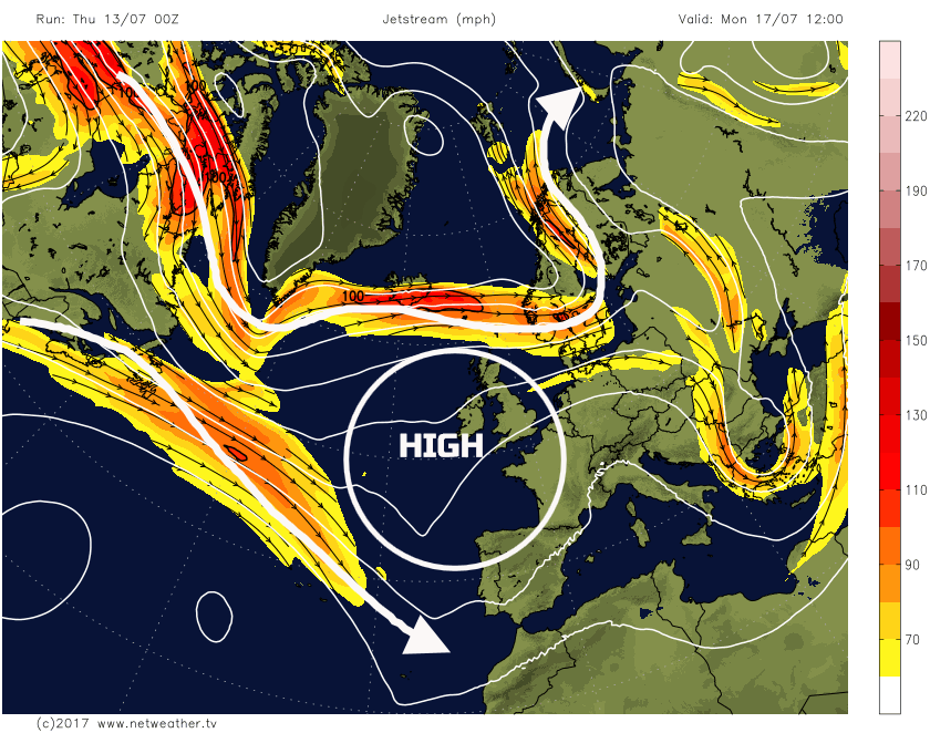
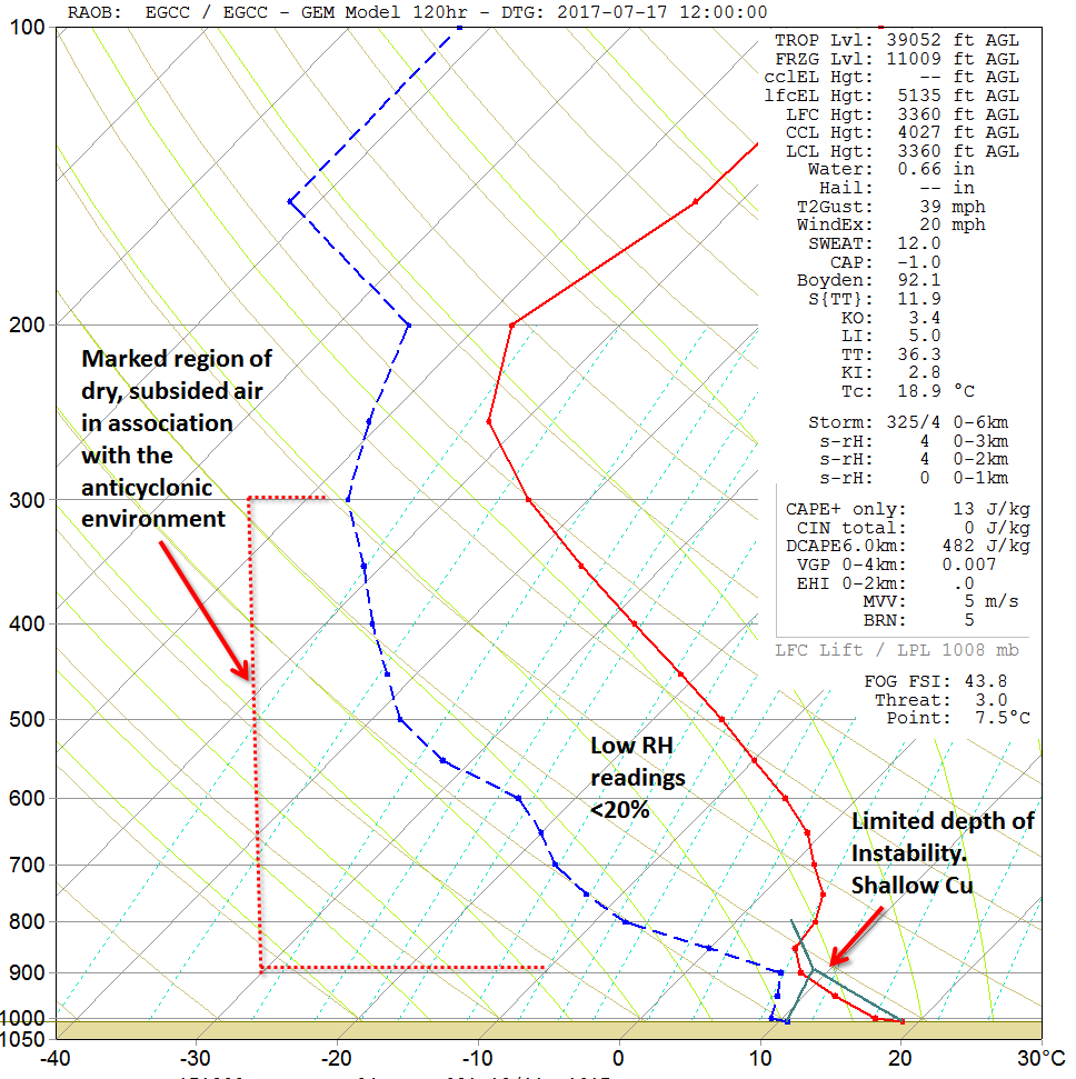
There is a good model agreement for this development and, as a result, the 00z GEM, GFS, UKMO and ECMWF by +120hr, so Mon and Tue of next week, have anticyclonic conditions dominating across the British Isles. Conditions are likely to be predominantly dry with some bright or sunny spells, and it will be warm, if not very warm. However, this will be dependent on how much of a continental flow can develop and the precise centre of gravity of the surface high. Forecast soundings suggest quite a homogeneous environment across many areas. The forecast sounding into Monday, for Manchester, highlights a dry atmospheric profile which would lead to just some fair weather Cu, otherwise plenty of sunshine.
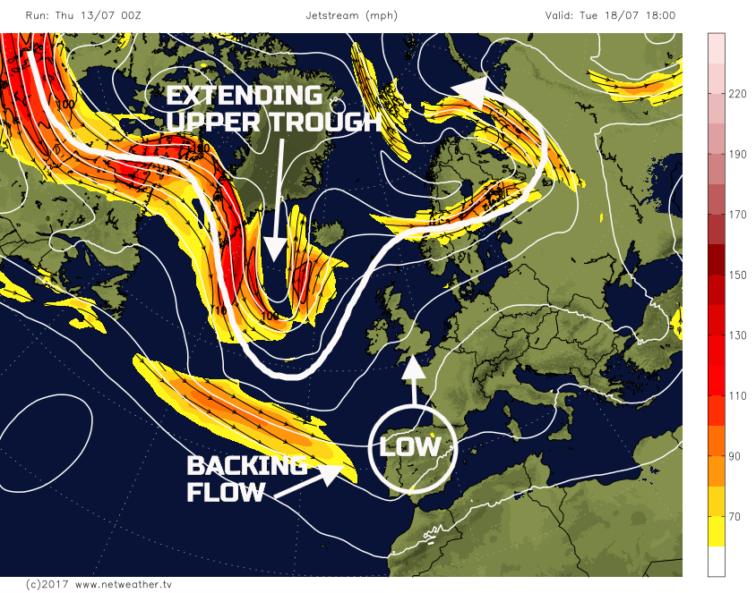
As we progress towards the middle of next week and the processes across the N Atlantic become particularly intricate. An upper trough extending down out of the Greenland area will aid in producing a more cyclonic region of weather to the W of the British Isles. However, of importance, is that this process of the trough extending allows the surface flow to back and then leads to the northward movement of an area of low pressure out of Iberia. The backing of the surface flow also leads to a marked rise in thicknesses, with, currently, 850mb WBPT’s set to increase to between +16C and +18C by Wednesday.
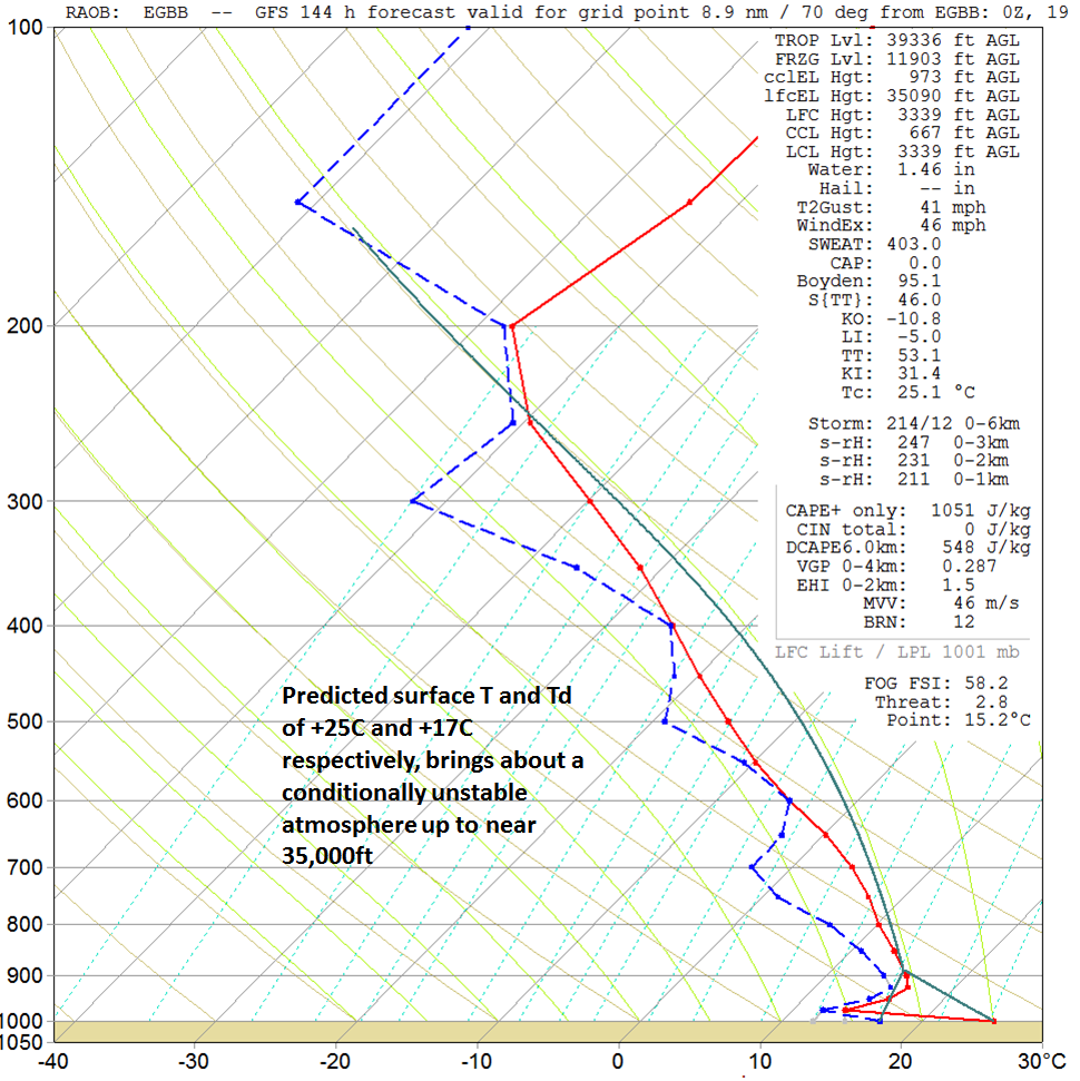
All the 00Z GM’s by the time we get to the 19th are in reasonable agreement now regarding this synoptic process. Confidence is increasing that after a warm and settled start to the week, it will become increasingly hot and humid. The details of this, at the moment, are uncertain. However, with the high WBPT plume heading northwards and with the flow distinctly cyclonic then, the current thinking is that there will be a significant risk of some convective activity towards the middle of next week. Latest forecast soundings for Birmingham, as an example, highlight a conditionally unstable atmosphere as the day progresses. Surface conditions (temp and Td) modified to near +25C and +17C do lead an unstable profile with well over 1000j/kg of CAPE, and there is some significant wind shear too. As a result, the convective threat for the middle of next week is on the increase.
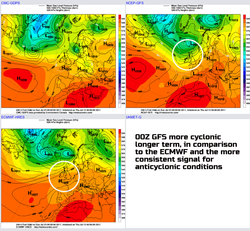
As we move beyond the end of next week and look towards the end of the month, there has been quite a consistent signal within the GFS and EC ENS for a more settled period of weather. The EC monthly, along with support from the GM’s, out to T+240hrs has shown a more anticyclonic end to July. However, the developments during the middle of next week will be crucial regarding the synoptic pattern further down the line. This development of a more cyclonic regime around the middle of next week may well lead to the renewed development of a more zonal flow. The 00Z GFS model, for example, has progressed in this direction. However, the ECMWF remains entirely consistent in allowing the Azores high to extend north-eastwards up towards NW Europe and allow for a more sustained period of settled and summery weather.
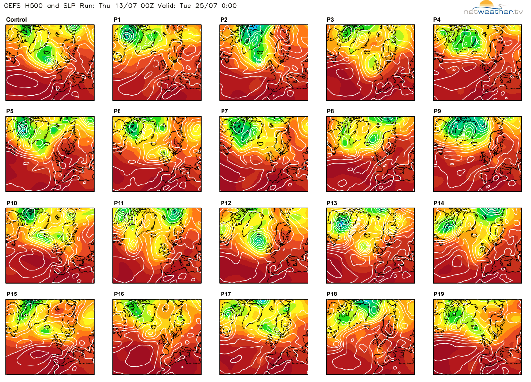
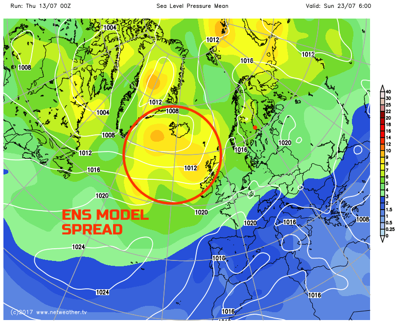
There have been some occasions where anticyclonic conditions have been signalled at longer time frames this summer, but of which have failed to materialise, on most occasions. Both the EC monthly, along with the GFS and EC ENS have, at times, produced blocked regimes with anticyclonic conditions dominant across the UK. Overall, this evolution has failed to arrive, despite some settled weather at times. The spread in the GFS ENS, especially to the NW of the UK by Sunday 23rd is pronounced, this highlighting plenty of difference within the GFS ENS as to whether lower pressure will be more influential here, as per the 00Z GFS Det, or whether it is more settled with higher GPH.
Taking a look at the individual 00Z GFS ENS postage stamps, by the time we get to the 25th of July highlights this spread. There are some anticyclonic solutions, including P1, P5, P8 and P9 for example, but with apparently some marked cyclonic evolutions in there as well. Examination of the 00Z EC Clusters highlights some spread, but with greater emphasis on the more anticyclonic evolution. There has been a trend, especially from within the GFS ENS for a trend away from the more settled outlook and, given the reliance of the likes of the EC monthly by week three, for example, along with this signal for more settled spells late on not to materialise, then caution is required. However, for now, the more anticyclonic outlook is tentatively followed for the end of July and perhaps into early August.