Rising temperatures and humidity bringing a brief taste of summer, but after that low pressure is set to dominate.
Issued at 1500BST on Tue 4th July based on Tue 4th July 00Z Model Runs
Key Points
Discussion:
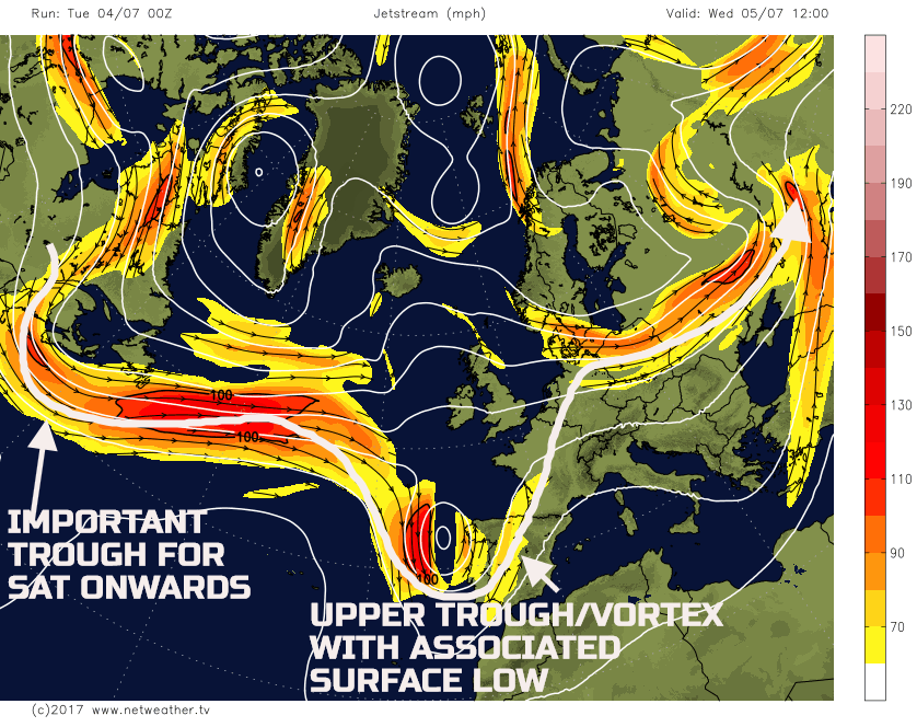
Wed 5th July: During Wednesday there is a good model agreement between the ECMWF, GFS, UKMO and GEM for an upper trough to be in evidence to the S of the UK, towards Iberia. The trough/vortex will be associated with low surface pressure, of which will be aiding to back the surface flow and allowing for an increasingly warm and humid air mass, characterised by >+16C 850mb WBPT’s, to move N. For much of Wednesday though the atmosphere is stable and a predominantly dry day with some bright or sunny spells will develop for many regions. There will be an exception, more on this shortly, but the overall upper-level 300mb pattern is exampled well by the 00z GFS.
Through the course of the day, there will be a zone of mostly cloudy and damp conditions lying across parts of Ireland, N England and S Scotland, of which will be in association with the remnant frontal zones from Tuesday’s wet weather. The frontal zone will undergo frontolysis through the day, but it’ll have enough cloud associated with it to bring some nuisance value patchy light rain and drizzle, to the regions mentioned. The other potential development is that the added surface moisture, when coupled with some possible solar input, could lead to the isolated surface based convective showers across parts of N England and the N Midlands.
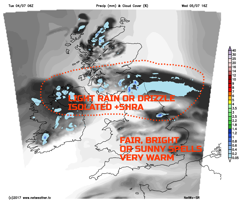
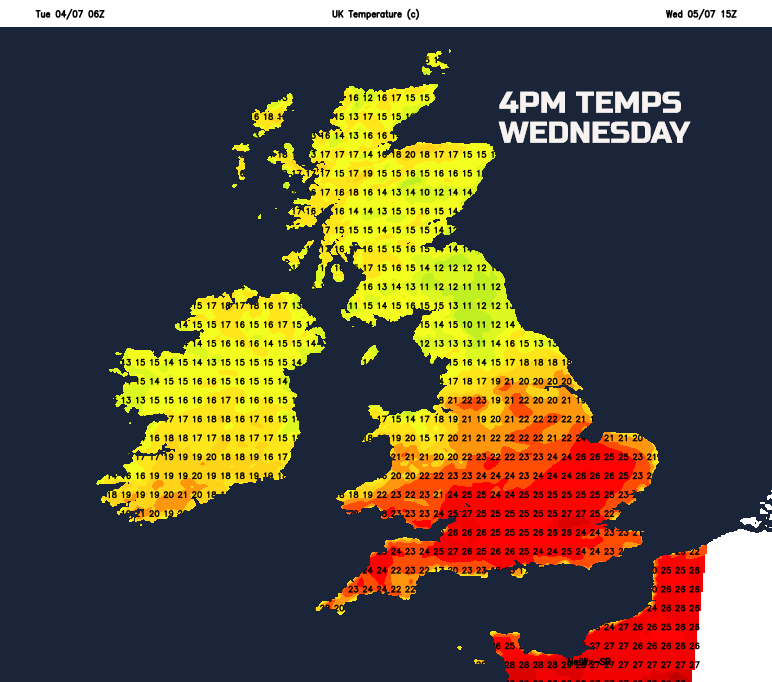
Temperatures on Wednesday will begin to respond to the increasing thicknesses from the S. However, there could well be quite a marked region of depressed temperatures, beneath the thicker cloud, across parts of N England and S Scotland. However, temperatures across many central and southern areas of England and Wales will widely reach 21C to 25C, but 26C to 29C, is certainly possible W of Greater London, for example. Our SR model may well be indicating too low maximum temperatures across some areas of N England and S Scotland, but it does highlight this potential divide in values through the day quite well.
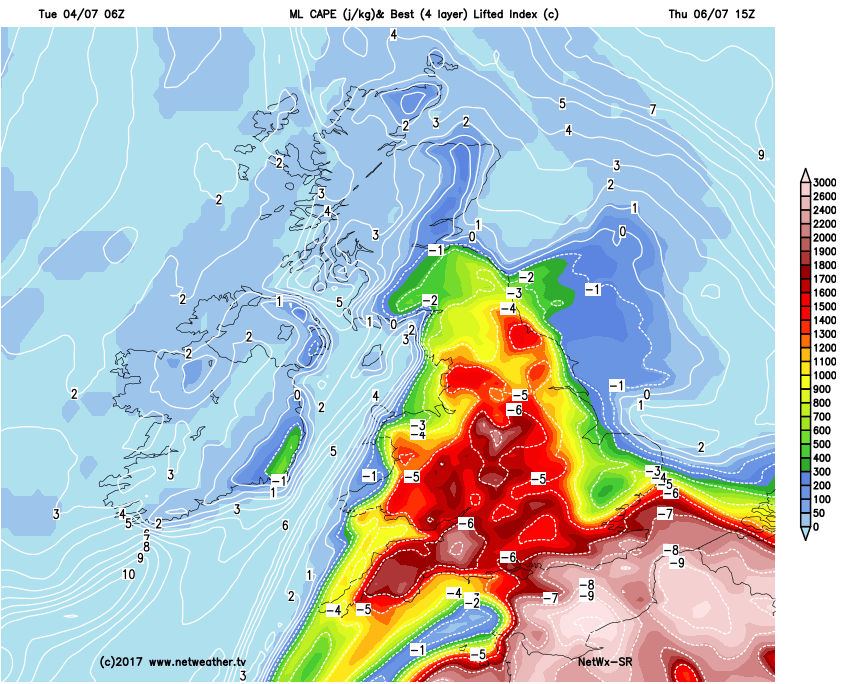
Thu 6th July: Into Thursday and the heat begins to build markedly across much of the British Isles, but especially so across England and Wales. 1000-850mb thickness values will be widely above 138dam, locally nearing 140dam across S and SE England. These values will be associated with well above average temperatures and with an increasingly humid feel as well. The main surface low pressure, drifting northwards out of France, will be a primary factor in aiding convective development through the day. With little inhibiting factors currently forecast, then it is more a case of where and when the convective activity develops on Thursday, rather than if.
Focussing on that first and there could well be some mid-level instability in evidence, first thing, across parts of Wales and SW England, this directly associated with a plume of WBPT and some approaching vorticity. So, some thundery downpours could be in evidence here early in the day. As temperatures rise further through the course of Thursday, in response to bright or sunny spells, then rapid convective towers will develop, with Tcu and CB activity likely quite widely. However, it is the finer details that remain uncertain as to which areas of England and Wales will see the greatest risk of thunderstorm development. Given that the atmospheric conditions are forecast to be quite uniform in England and Wales, then more local convergence zones, forcing details and higher elevations could well make all the difference as to which areas see storms or not.
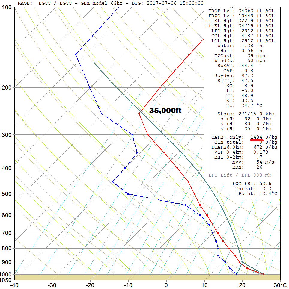
The forecast sounding, for the middle of the afternoon on Thursday, for Manchester highlights the general profile quite well. With surface temperatures nearing 23C to 25C, which should be readily achievable, along with elevated Td’s, then deep instability is forecast. Cloud tops up to near 35,000ft are possible and with potentially more than 1500j/kg of CAPE as well. While not visible on this particular sounding, there is likely to be reasonable speed and directional wind shear, so a good exhaust at the top of that troposphere, aiding development too.
Organised convective activity is certainly possible; perhaps some short-lived supercell activity, MCS and potential back-building too. All these result in a risk of some potentially severe convective weather on a local and regional scale, in places, across parts of England and Wales on Thursday afternoon and evening. Torrential rain, leading to flash flooding, large hail and strong, convective wind gusts are all potential hazards.
As a general guide, using our MR model, then the primary risk areas could well be across parts of S England, up towards Wales and the Midlands and potentially N England too, at least initially. Once again though, the finer details will determine the more localised risk, but at very short lead times.
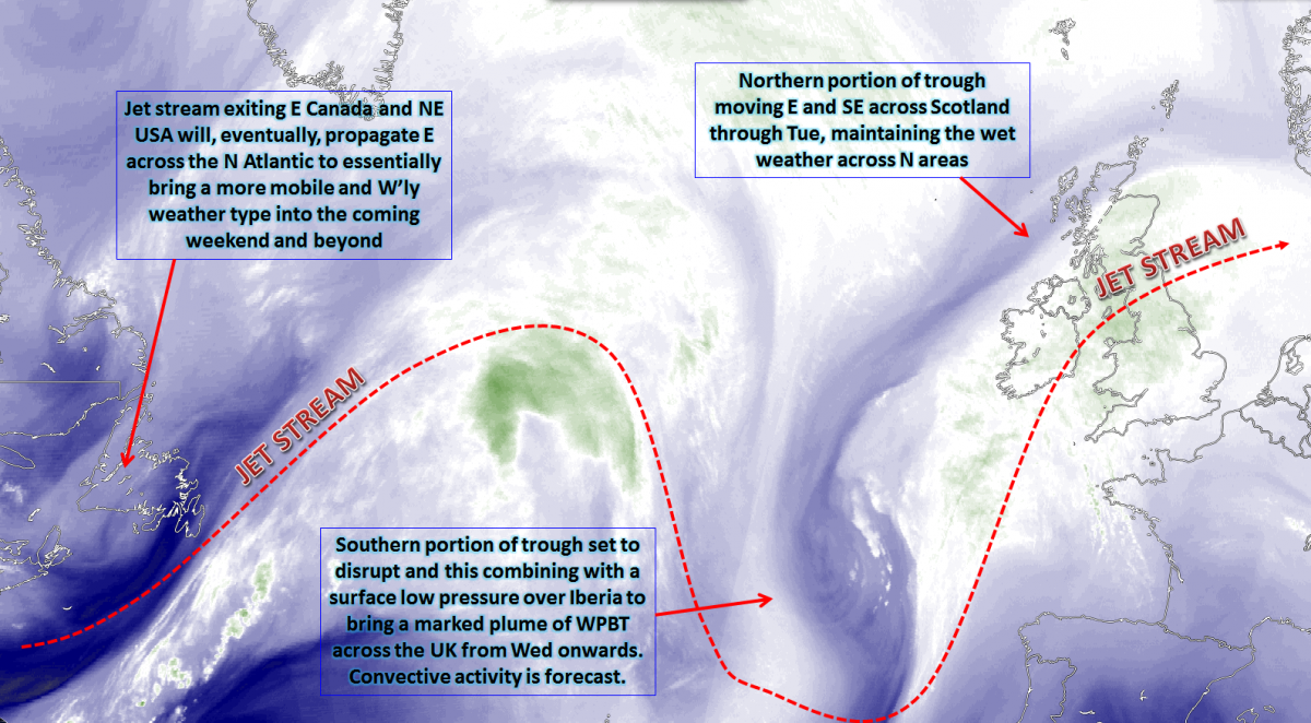
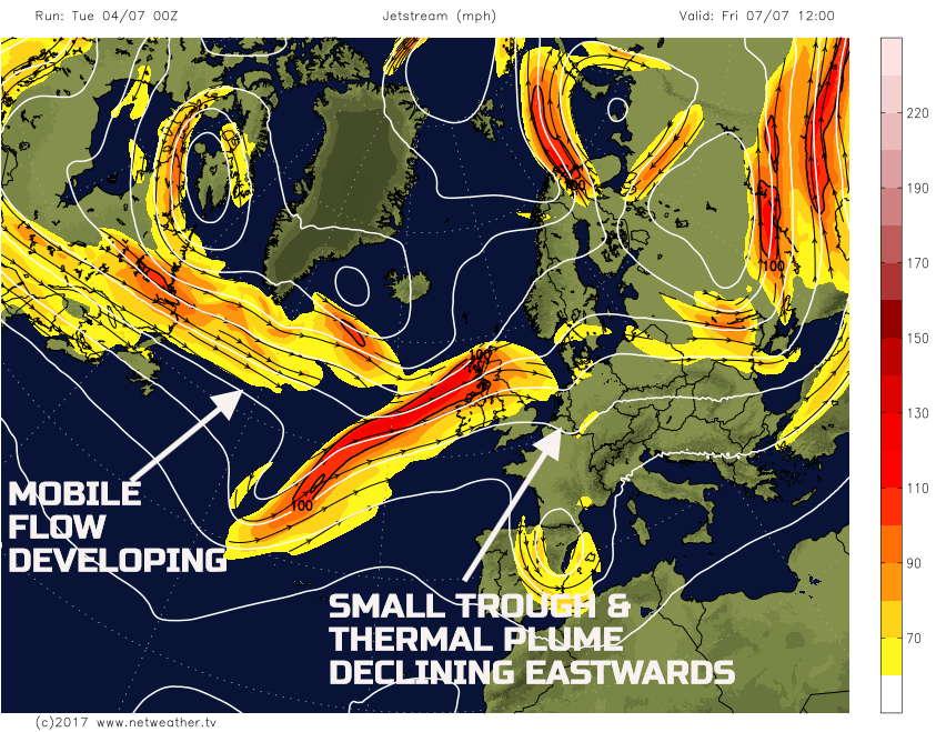
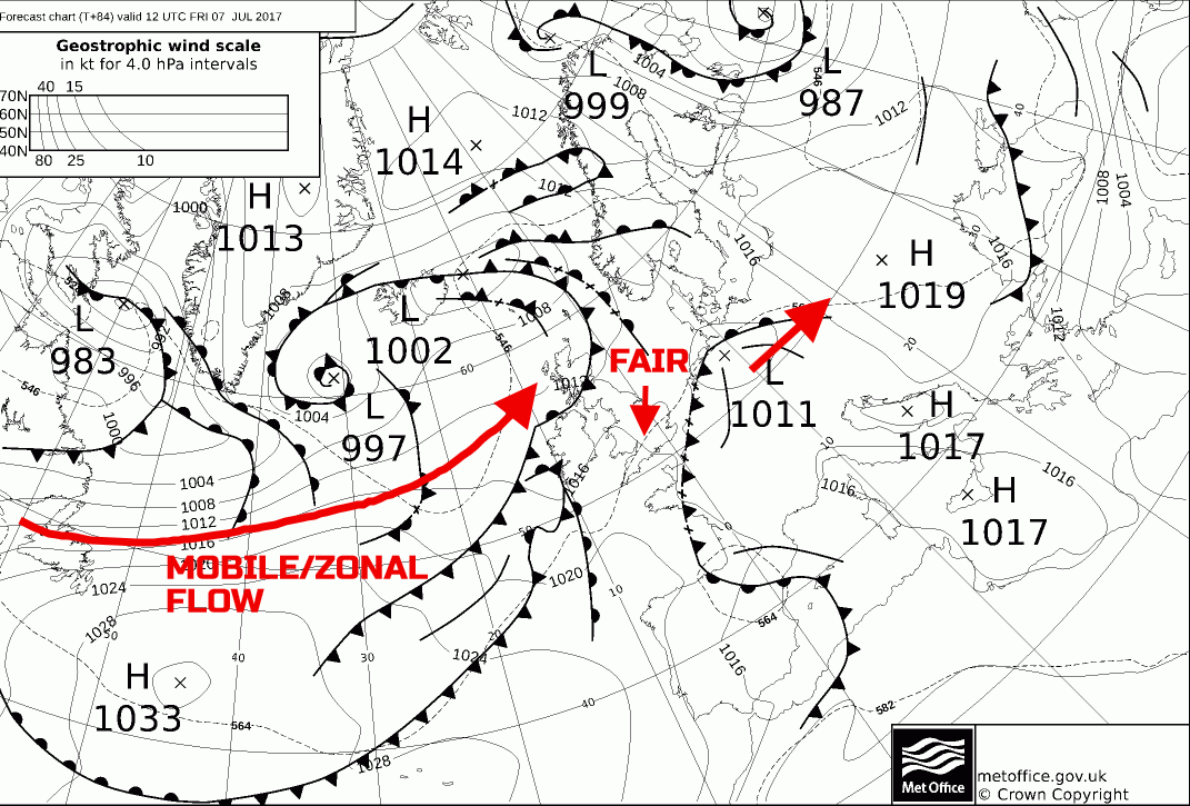
Fri 7th July: Overnight and into Friday, and there is the possibility that overnight convective activity still lingering across parts of E England and SE England. The details of this risk are uncertain, for now at least, but a risk is likely first thing. As Friday progresses and the main thermal plume of +16C to +18C WBPT will begin to clear away to the east. Slow progression towards a more zonal flow in evidence from the W will then develop. The 00Z ECMWF, GFS, GEM and UKMO are all in generally good agreement regarding this evolution; the 00Z GFS used as a guide.
Once any overnight convective activity clears away, timings uncertain of course, then, overall, much of Friday looks to be a mainly dry day for many areas, but especially across England and Wales. Some bright or sunny spells will develop, and some residual heat and humidity does mean another warm day, but perhaps not quite as hot as compared with Thursday. The approaching more zonal flow though will be associated with the surface low-pressure development and frontal zones. As a result, this will mean that as Friday progresses outbreaks of more dynamic, frontal precipitation, are currently forecast to move into Scotland and Ireland through the second half of the day, and it is then behind the fronts that a change to markedly cooler and fresher weather then arrives. The 00Z UKMO FAX for T+84h 12Z Fri highlights the declining convective region, associated with the 1011mb low to the SE, while more active, Atlantic frontal zones move into the N and W.
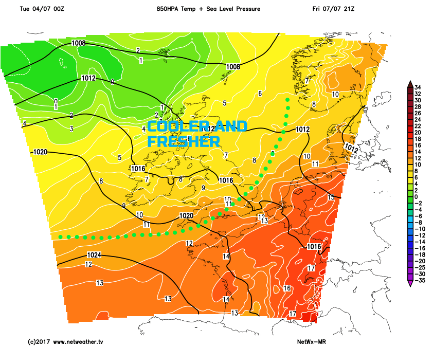
These outbreaks of rain will then steadily move SE overnight into Saturday, most likely weakening as they do so though, given that there is some model agreement for the primary forcing, to either run away to the NE or mostly lose contact with the surface frontal zones. Importantly though it will lead to much cooler and fresher air, this highlighted on the below 850mb chart late Friday.
Sat 8th and Sun 9th July: So, we move into next weekend, and the residual frontal zone is likely to be producing some showery outbreaks of rain across central, southern and south-eastern areas of England during the morning. However, the precipitation will ease or fizzle out, and many parts will then have mainly dry conditions through Saturday afternoon with some bright or sunny spells. A minor and transient ridge of high pressure is then likely to topple down into the UK from the W or NW, this well modelled, so a reasonable day for many on Saturday, but markedly cooler and fresher than compared with preceding couple of days.
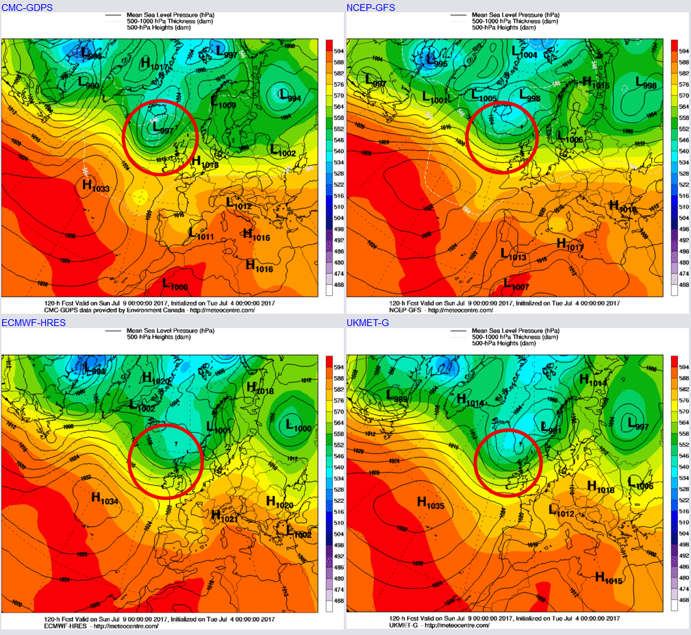
Into Sunday and, at the moment, another frontal system is likely to approach from the NW. The 00Z ECMWF, UKMO, GFS and GEM all have a low surface pressure, to some extent, in evidence to the NW as we move into Sunday the 9th. The associated frontal zones will then move across Scotland and Ireland, at first, before then moving SE through the second half of Sunday. The amount of precipitation associated with these fronts is uncertain and, equally, the timing of how quickly they move SE is uncertain too. However, it is likely that many central, southern and eastern areas of England will have a decent day on Sunday with some bright or sunny spells, ahead of cloudier and wet weather arriving late in the day.
Medium and Longer Term 10th July onwards:
Looking further ahead and, unfortunately, the outlook does look distinctly cyclonic. The predicted development of the more zonal and mobile pattern across the N Atlantic later this coming week and into the coming weekend, is set to continue towards mid-month. The latest EC Monthly supports this development, as does most of the GM’s out to 240hrs, along with the 00Z GFS and EC EPS too.
Despite uncertainties over the details, it does look as though much of the British Isles will see some frontal systems running into the UK from the W or NW through towards mid-month and perhaps beyond. It is likely that the poorest weather though will be across more N and W areas, while short and transient ridges, extensions of the Azores high, perhaps bring some settled weather in the south. Overall, though the outlook is far from summery and the latest GFS ENS mean, by the 12th, highlights this quite pronounced zonal flow, as a cyclonic W or NW’ly airflow dominates.