Yesterday was the hottest day of the year so far, with 30C in London, but we could get hotter still over the next few days. Cooler and fresher conditions in the north spreading south by mid-week, before turning hot again Thursday.

Saturday was the hottest day of the year so far, with a number of spots in London hitting 30C. We saw temperatures reach the high 20s across much of central, southern and eastern England along with east Wales though too in the long sunny spells which bathed many areas. It wasn’t sunny everywhere though, with a weather front bringing cloudy and damp weather to western Scotland.
Sunday will be a repeat performance of yesterday, with another sunny and very warm or hot day across much of the UK, however, the far northwest will again be plagued cloud and risk of rain. Little change on Monday, with temperatures reaching the mid-to-high twenties across England and Wales, while cooler and fresher conditions spread down across Scotland and N. Ireland. These more comfortable conditions behind a cold front spreading south across most areas on Tuesday, though still very warm and sticky across the far south. Cooler and fresher briefly for all on Wednesday as winds turn easterly for a time. But the heat and humidity looks to return on Thursday across central and eastern parts as winds turn southerly, with it a growing risk of thunderstorms too, heat lasting into the early part of the weekend across the south before most areas eventually cool off from the west.
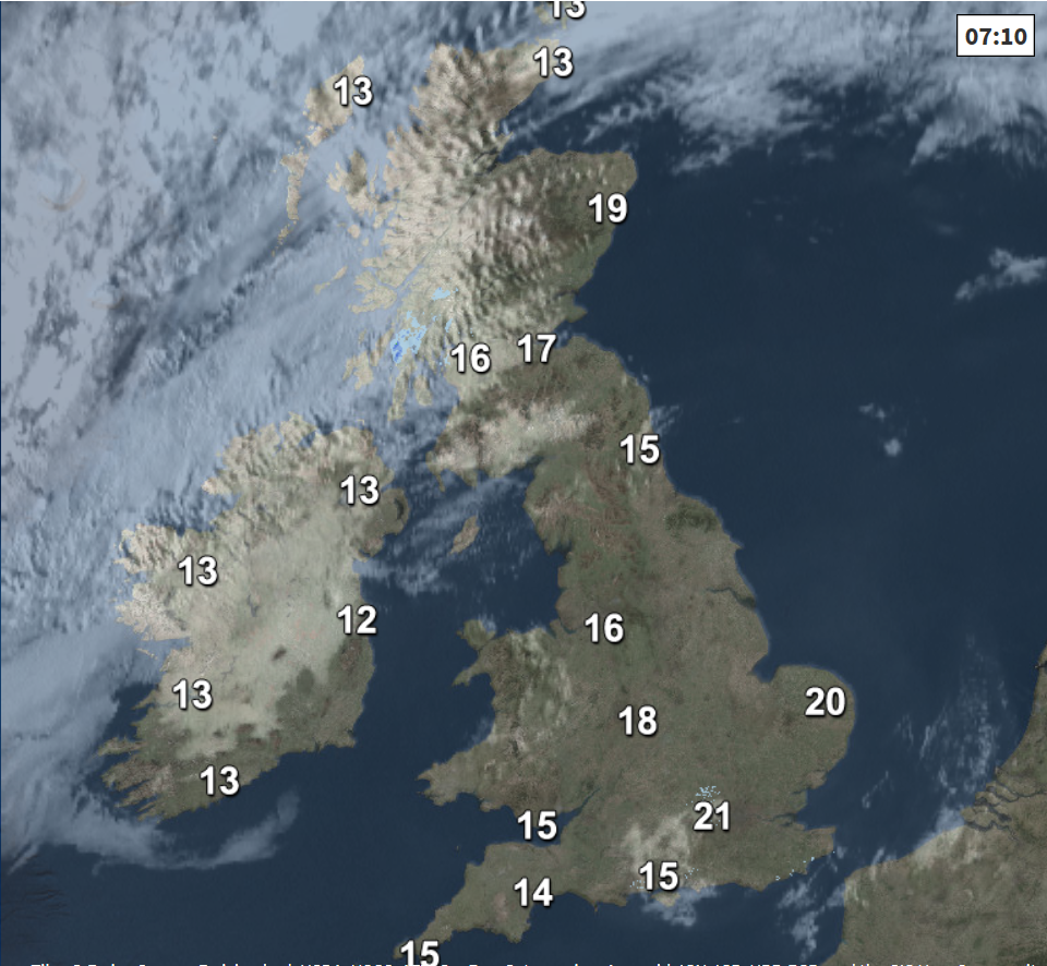
For now, after a warm and muggy night across England and Wales, an uncomfortable sleep for some, Sunday is already warming up quickly with the sunny start for many, temperatures at 7am already 18-21C across London and the southeast. It’s a cloudier and damp start across parts of N. Ireland and Scotland though, the cloud will tend to break to allow some warm sunshine across southern parts of N. Ireland and Scotland, but further north the cloud will remain thick enough for some patchy rain at times. But for much of England and Wales it will be another fine day with prolonged sunny sunshine, becoming hot across central, southern and eastern parts. Just and outside chance of catching an isolated thundery downpour developing in the heat of the afternoon across eastern England.
Temperatures reaching 31-32C towards London and the Home Counties, mid to high 20s elsewhere across England and east Wales. Where the sun comes out across southern Scotland and N. Ireland, temperatures reaching the low to mid 20s. There will be high levels of pollen and very high levels of UV, so if you are thinking of headed to the beach, make sure you are wearing sunscreen.
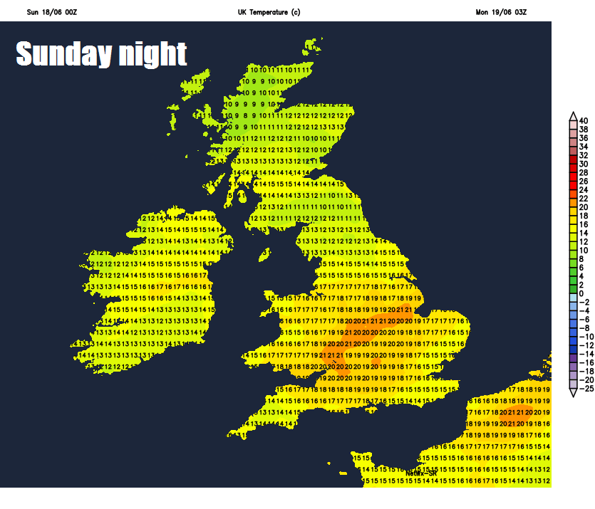
Cloudy with outbreaks of rain continuing across northern Scotland, elsewhere a largely dry night with clear skies, another warm and sticky night across England and Wales, temperatures perhaps falling no lower than 20C in London, high teens in towns and cities elsewhere across England and Wales.
As we start the new working week, high pressure will slide east across northern Britain, so after some cloud and rain at first across the far NW on Monday, it will be largely dry for most on Monday and Tuesday. Remaining very warm or hot across England and Wales, fresher and cooler conditions spreading around the high pressure across Scotland and N. Ireland. A risk of an isolated heavy thundery downpour developing across central areas on Monday, then SW England and south Wales on Tuesday.
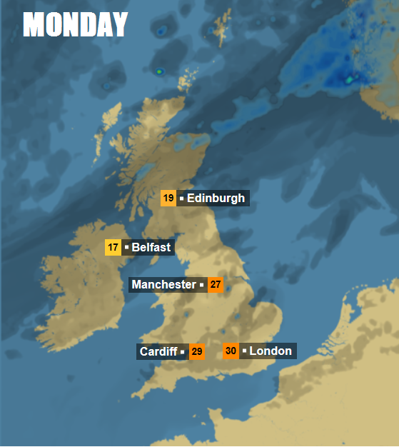
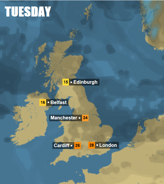
Temperatures peaking Monday across the north before dropping in Tuesday, 19-20C on Monday in Edinburgh and Belfast, 15C on Tuesday – further south 27-28C across northern England tomorrow, dropping to the low twenties on Tuesday, as cooler and fresher conditions spread south. Further south, temperatures also peaking tomorrow, 28C in Birmingham and Cardiff – dropping to 23-25C on Tuesday, 32C in London on Monday to 28C on Tuesday.
High pressure slides east into the North Sea on Wednesday, with cooler and fresher conditions across northern and eastern areas with an easterly or southeasterly breeze off the North Sea. But it should again be dry and sunny for many, though a risk of thundery showers spreading east across EIRE, N. Ireland, Irish Sea coasts and eventually western Scotland by evening. Very warm across the far south, with temperatures reaching the mid to high twenties, high teens to low twenties elsewhere.
Thundery downpours developing across the west later on Wednesday, before spreading east across northern areas, some storms also developing across central and eastern England on Thursday
Thundery downpours spreading east across the north on Wednesday night, clearing Thursday morning, then turning drier from the west across the north through the day. Becoming very warm or hot and humid across southern areas, which could trigger some thunderstorms across central and eastern England in the afternoon. Hot and mostly dry towards SE England on Friday, cooler and fresher further north and west, cloud and rain possible for Scotland and N. Ireland, otherwise dry.
Heat returns across the south Thursday and Friday