The European ECMWF weather suggesting a heatwave for the UK later next week, but the American GFS weather model disagreed on the 00z runs this morning. Who's likely to be right?
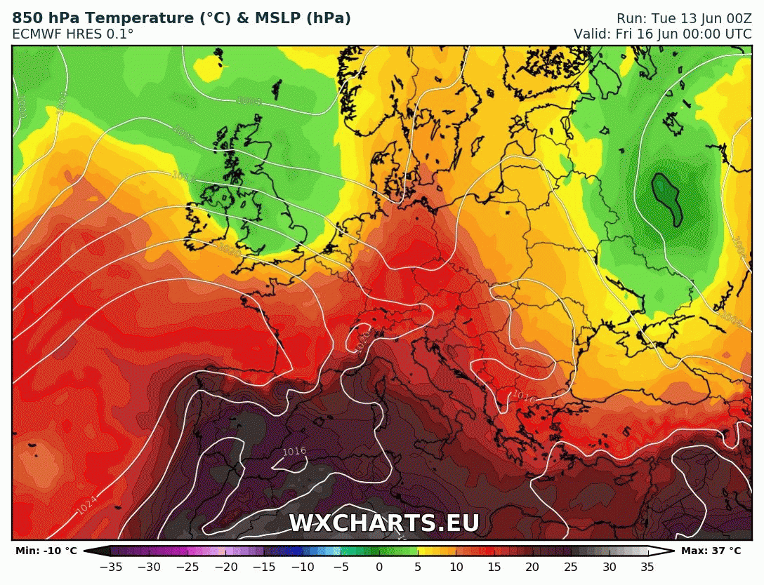
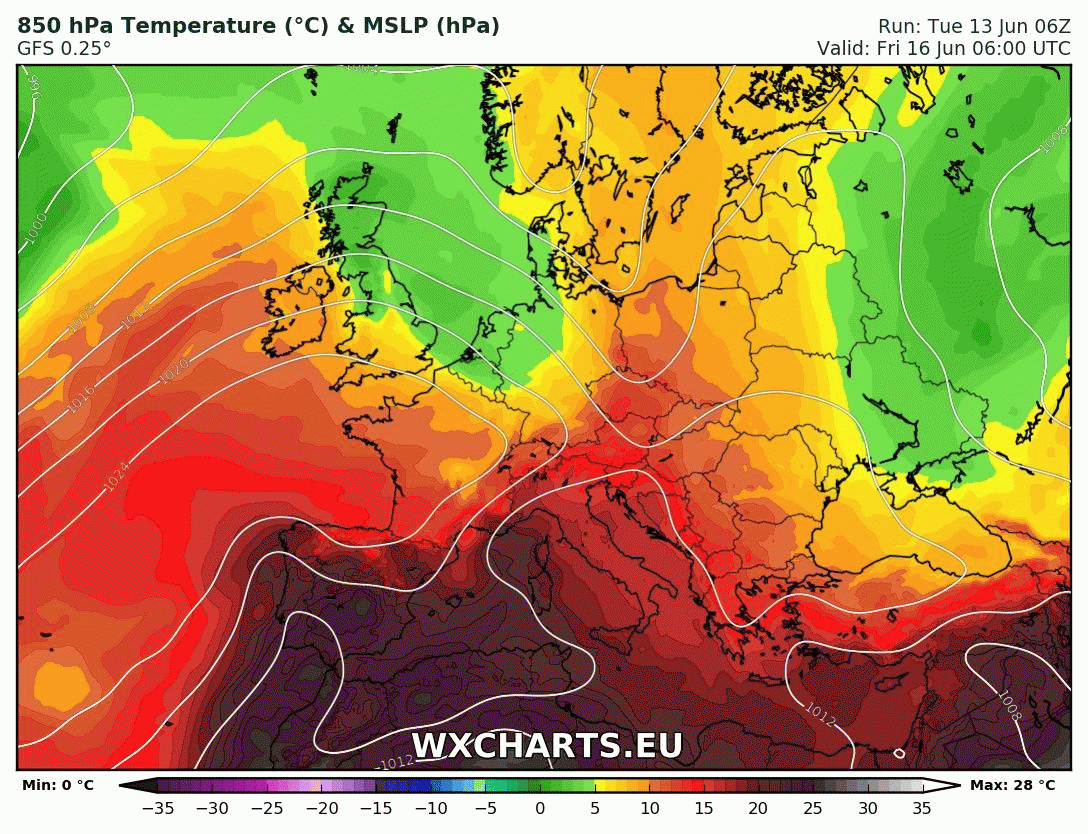
It’s warming up across many areas over the next few days, as low pressure to the west over the Atlantic and high pressure close to the east draws north warm and humid air sitting over France over the last few days. Temperatures look like hitting 27-28C across SE England tomorrow, before cooling down a little by the end of the week, as a cold front introduces fresher conditions from the west during Thursday. However, high pressure will hold on across southern Britain through the weekend, allowing it stay warm and sunny, Scotland, N. Ireland and northern England cloudier and cooler with some patchy rain at times, as Atlantic fronts pass through here.
The best performing medium range weather models, ECMWF and GFS, are at odds though over the outlook for next week on the 00z runs that came out earlier this morning.
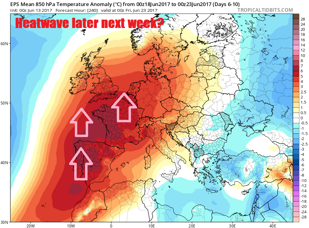
The European ECMWF weather model, regarded at the best verifier in the medium range, shows a long-wave upper trough digging southeast across the North Atlantic next week on the 00z deterministic/high res run, becoming quite amplified in southern extent toward Maderia as it moves across the eastern N Atlantic. This allows a plume of hot air building over Iberia and SW France this weekend and early next week to spread north across the UK later in the week.
00z ECMWF high res shows pulme of hot air spreading north to the UK later next week (credit: wxcharts.eu)
However, the American GFS weather model shows a cooler picture, it briefly amplifies an upper trough over the NW Atlantic before the upper westerlies cut-off into upper low which drifts SE towards the Azores, a flatter upper flow is left across the far north Atlantic with little amplification south, the upper flow and surface flow westerly or northwesterly across the UK through much of next week, supressing temperatures and also eventually allow low pressure with wind and rain to move in from the northwest after a dry start to the week.
00z GFS keeping it cooler in a westerly flow - especially toward end of next week (credit: wxcharts.eu)
So, some quite large differences between these two high-resolution runs from the 00z runs for the medium range taking us through next week. In such circumstances, it’s worth using ensemble guidance, ECMWF runs 51 ensemble members, the GFS has 20. All of these ensemble members are run at lower resolution, apart from the high resolution out to day 10 (t+240), but these members which have the same starting data but are tweeked, they can cluster more round one outcome than another – which gives the forecaster more confidence in that higher cluster – if there are uncertainties with the higher resolution runs.
Often it’s worth using a mean of the ensembles to pick out the most likely evolution. Though this doesn’t always work if there the ensembles generate two or more clusters of similar ensemble members, which can be hidden by the ensemble mean.
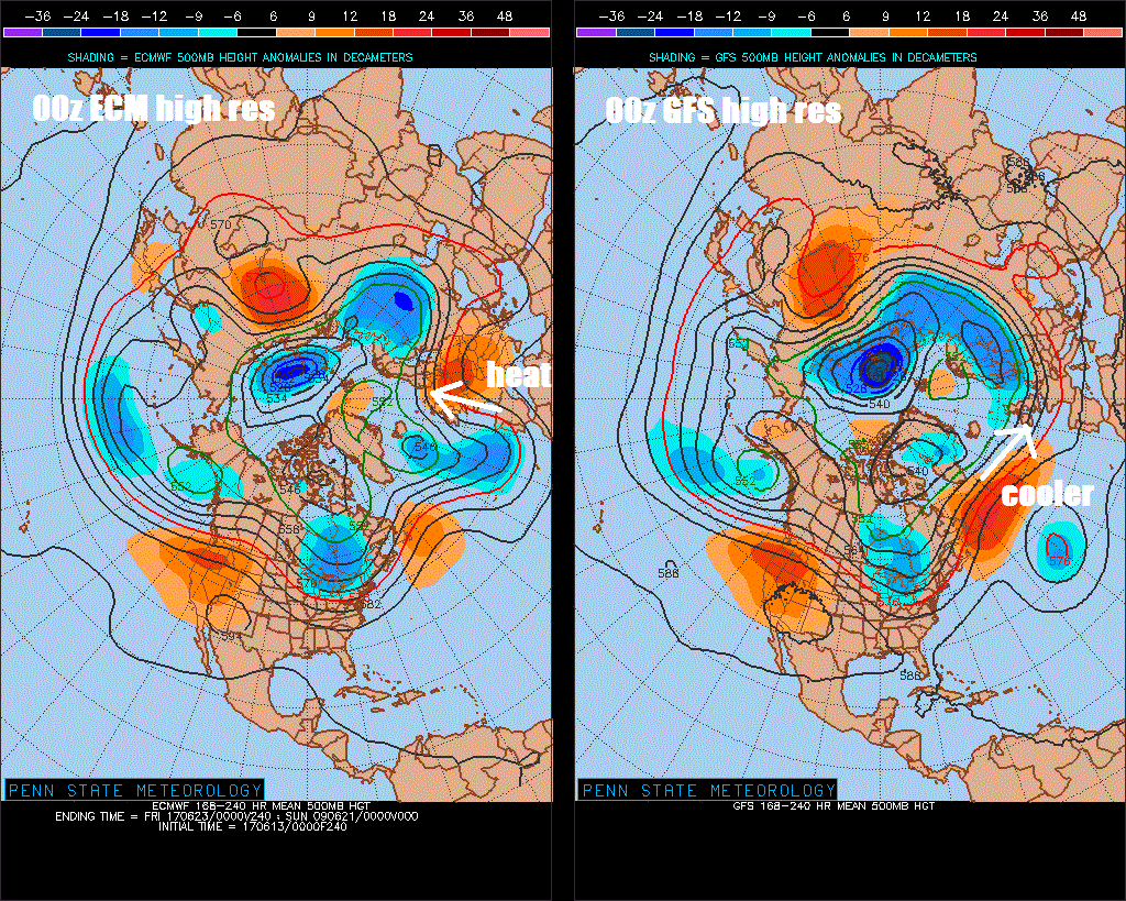
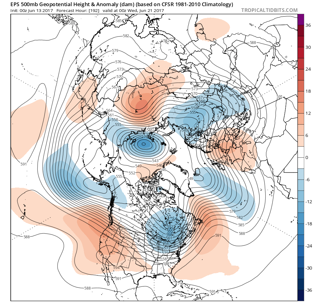
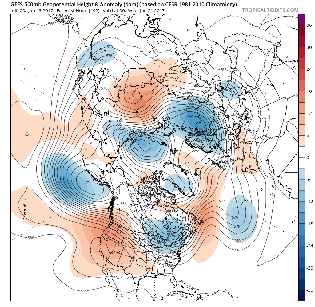
Unfortunately, the GFS(GEFS) and ECMWF(EPS) 500mb height ensemble mean can’t agree on the upper pattern either! The two 500mb ensemble means (upper flow easier to model than surface flow) below show the differences. GEFS has signs of a cut-off upper low down near the Azores at t+198 (00z next Wednesday) with a broad westerly or northwesterly flow into northern and western Europe. While the EPS for the same timeframe has that deep amplified upper trough, like the high res run, extending south from Iceland area down to the Azores with a ridge to the east of UK extending north from southern Europe across Germany and Denmark.
00z ECMWF mean 500mb height and anomaly for 00z Weds 21 June
00z GFS/GEFS mean 500mb height and anomaly for 00z Weds 21 June

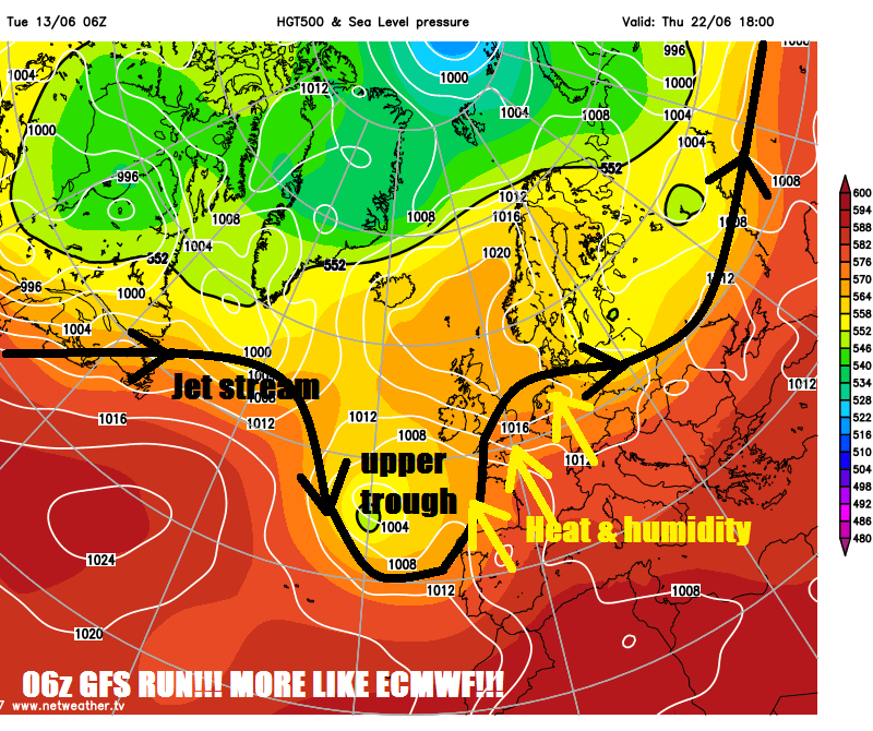
The latest 4x daily GFS runs, the 06z, seems to be siding more toward the 00z ECMWF high res and EPS 500mb mean. So, for now, looks like ECMWF could more likely verify, though I await the 06z GEFS 500 mean to see if it changing tact with the upper flow across the Atlantic next week. The 12z runs out this evening may shed more light on which direction we are headed too, though models may not firm up on mid-late next week for a few days.