


Synoptic Guidance - A Cool and Convective Outlook
Issued at 1500BST on Tue 16th May based on Tue 16th May 00Z Model Runs
Key Points
Discussion:
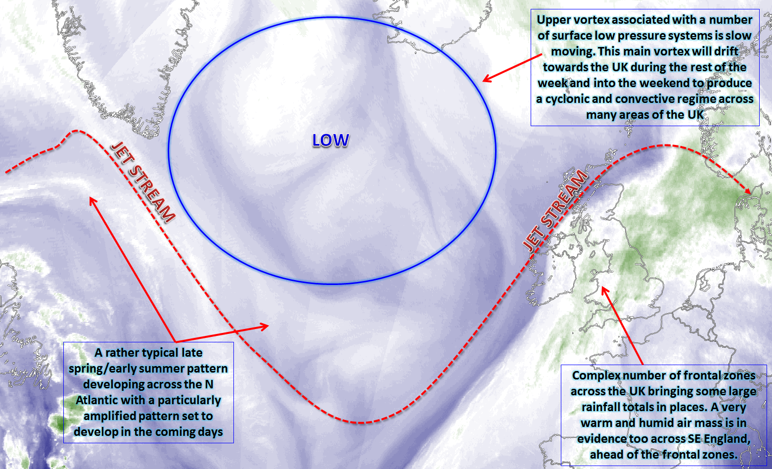
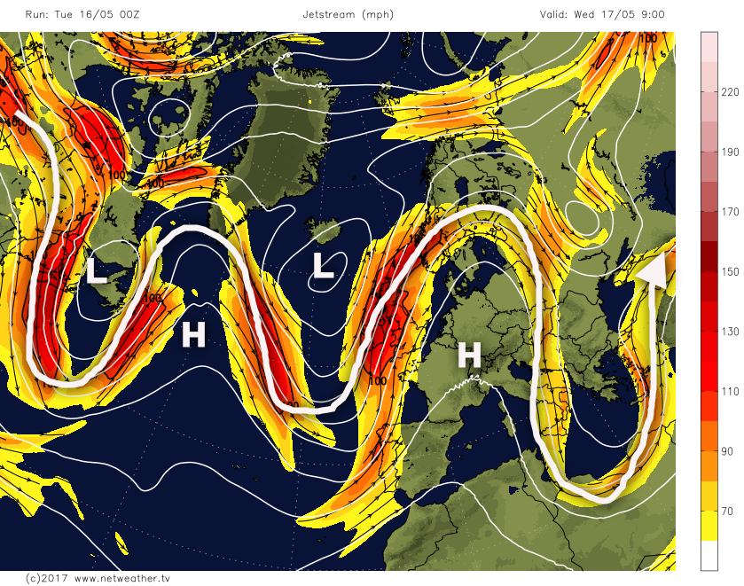
Wed 17th May: Into Wednesday and the broader synoptic pattern across the N Atlantic and into Europe is consistent in that quite a meridional flow is developing. What is often a feature of the weather at this time of year, various trough and ridge patterns become established. Depending on whether you are beneath a ridge or a trough determines the weather within that region. For the UK Wednesday will see an upper trough dominate the weather, but with the focus being on the combined development of both dynamic and convective precipitation across parts of the S and E England. The 00Z GFS model, as a guide, highlights well the developing trough and ridge pattern from E Canada into W Europe.
This pattern isn’t going to change much in the coming days and the trough, associated with an upper vortex to the W and NW of the UK, is what will drift into the UK domain through the rest of the week and maintain low GPH and, overall, a convective regime.
However, back to the details of the short term and attention is focused on parts of the S and E of England. Various regions of vorticity, originating to the S and SW of the UK, over Biscay and even further SW than this, will interact with a slow-moving frontal zone. The vorticity will aid in creating mass ascent and rejuvenate the intensity of the precipitation along the front. Complicating matters will be a particularly warm and humid air mass immediately ahead of the surface weather front. 850mb WBPT values will be more than +16C and, as a result, there is likely to be an element of convective activity too.
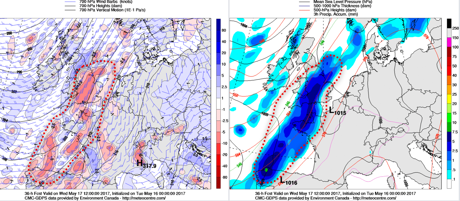
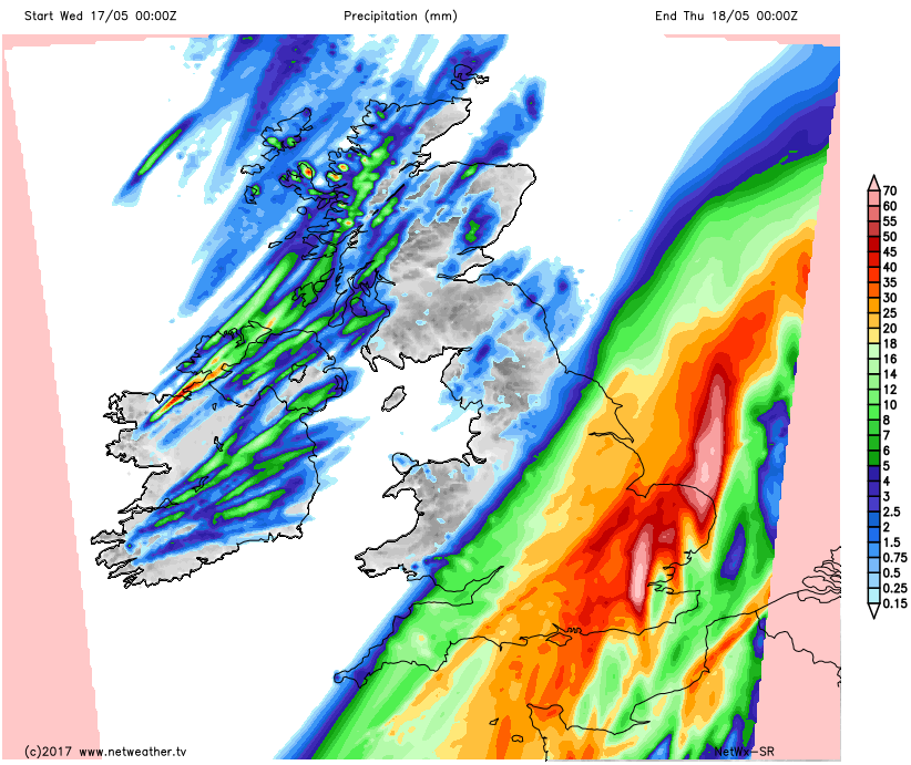
The exact positioning of the frontal zone, even at this stage, is a little uncertain, but it is likely anywhere east of a line from the Bristol Channel towards Birmingham and then up towards Hull will be at risk of some heavy rain as Wednesday progresses. There is widespread agreement from the GEM, GFS, UKMO and ECMWF for at least 25mm or more through central and eastern areas of England, but with locally higher totals certainly possible. Our model highlights the general area at risk of some of the largest totals, perhaps 40mm or more by the end of Wednesday.
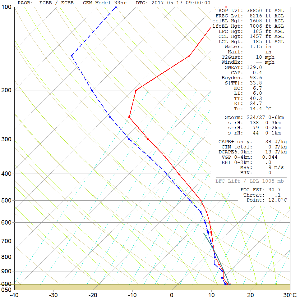
A sounding for Birmingham early on Wednesday samples the general area where frontal precipitation is most likely. The forecast sounding has all the hallmarks of a saturated profile, with high RH values from the surface right up to the top of the troposphere.
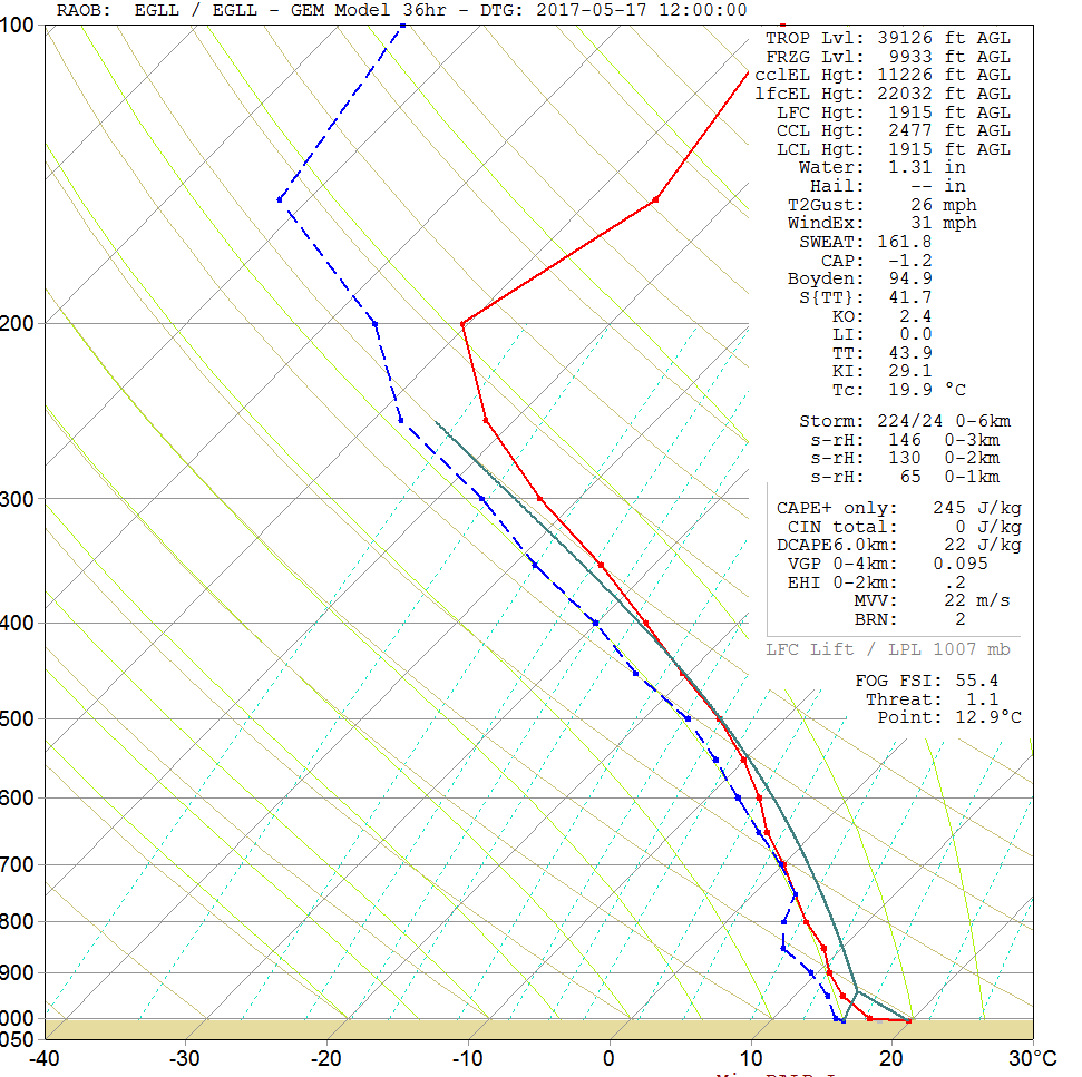
The convective threat is particularly uncertain because while it is likely to be a greater risk of thunderstorms breaking out of France, which may well arrive from the S and SW, there is also the threat of some homegrown storms too across SE England. However, the critical aspect of the forecast is that there is still likely to be the need for some cloud breaks immediately ahead of the main frontal zone to allow surface temperatures and dew points to rise to specific values to help initiate convective development. Whether there will be enough cloud breaks, and hence solar input, is very uncertain. The forecast sounding for London at 1200Z on Wednesday highlights a potentially unstable atmosphere, but surface temperatures of at least +20C will need to combine with surface Td’s of +15C or more. If convective development can occur, then there is certainly the scope for locally severe weather, primarily because the atmosphere will be particularly saturated with precipitation water totals more than 30mm. Clearly, within a convective regime, a lot of that would be released in a short space of time across SE England, leading to a risk of local flash flooding. The overall combination of frontal precipitation and possible convective precipitation means that many central, southern and eastern areas of England will experience one of the largest rainfall events in many weeks.
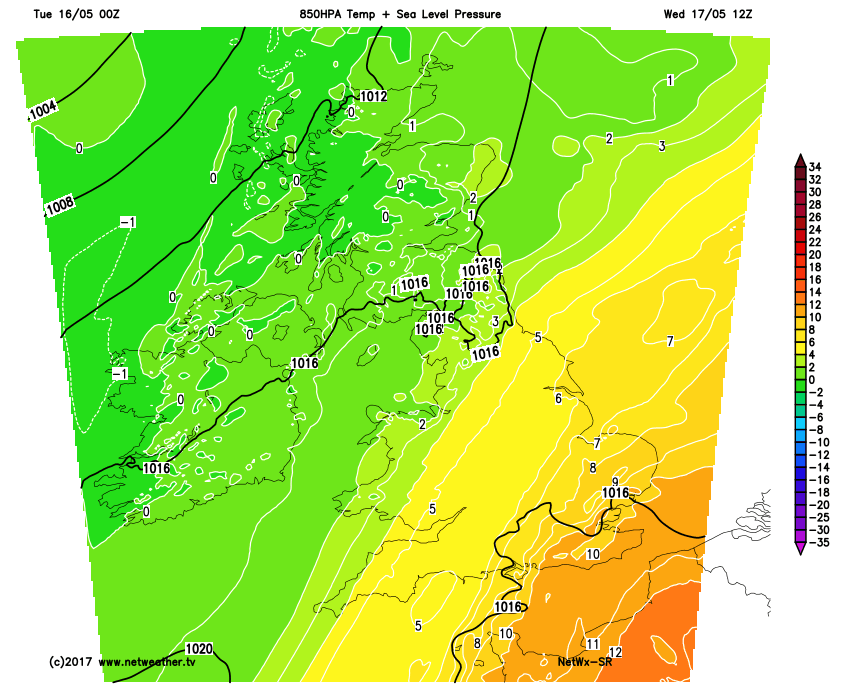
For the remainder of the UK, so across Scotland, Ireland, parts of N England and W Wales, Wednesday will be a much quieter day. A few scattered showers will develop, but there will be a lot of dry weather too with some sunshine and in comparison to further S and E, then conditions will be far more benign. Equally, a much cooler and fresher rPm air mass will mean a chilly day across the N and W than compared with further S and E, as exampled by our model showing 850mb temps with a marked thermal gradient across the UK.
Thu 18th and Fri 19th May: The working week comes to an end with a far more straightforward pattern across the UK, the broader pattern that is. The actual details will remain elusive until shorter lead times, but the main upper trough/vortex located to the W and NW will move into the British Isles. While the associated surface low pressure will be lacking any well defined frontal zones, there will be some occlusion debris and troughs associated with it. As a result, a simple mixture of sunshine and showers is the initial forecast, but there will be local and regional variations. The main upper trough and vortex of significance are in evidence by 00Z 19th from the 00Z GFS model. Importantly as well note how the upper trough is flanked, on either side, by two ridges. Essentially, this is bad news for the UK as these will help to keep the main upper trough/surface low pressure over the UK for some days and signal a cyclonic pattern well into next week.

Both Thursday and Friday will probably start mainly dry with some bright or sunny spells, especially across inland areas, but both mornings will be quite chilly too, especially rurally. As the day progresses and surface heating takes place, then the atmosphere will become unstable. Convective development is likely, and with light, steering flows where showers develop they will be rather slow moving and potentially merging to give longer spells of rain too. The details of any embedded occlusion debris or trough are very uncertain, but some more extended periods of rain can’t be ruled out, these perhaps most likely across parts of Ireland, Wales and W Scotland.
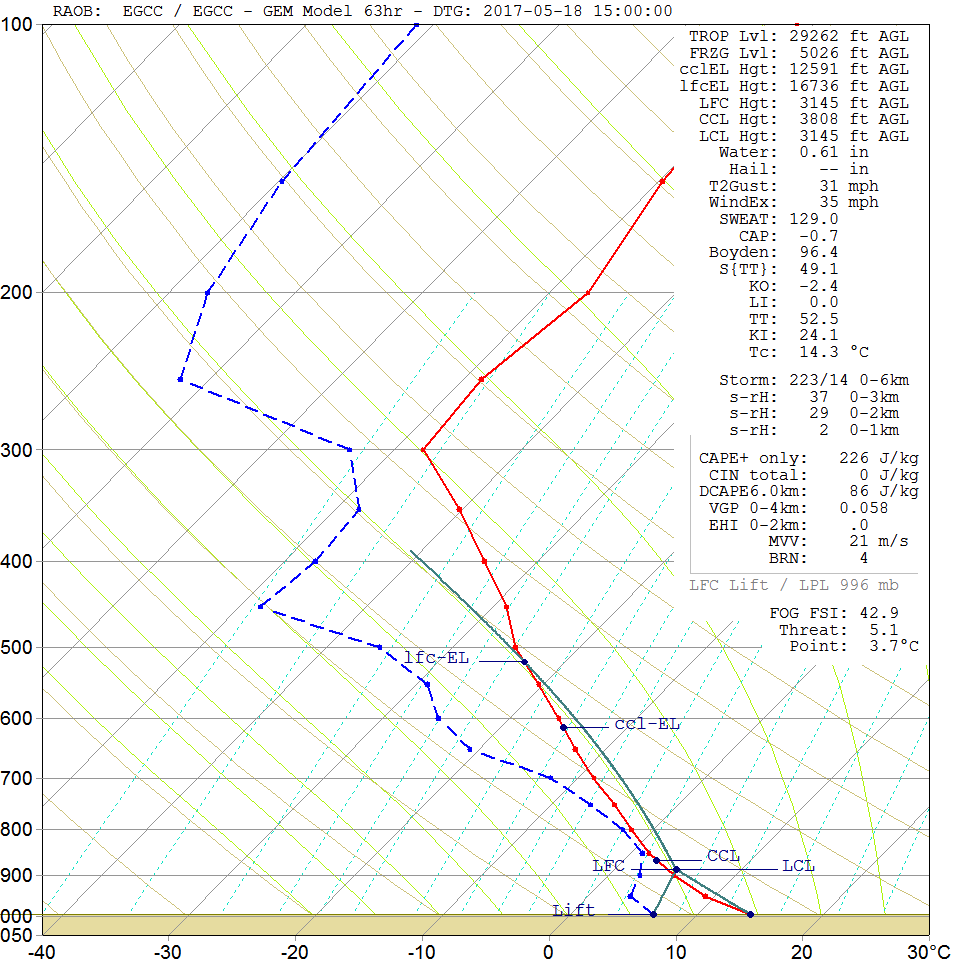
The forecast sounding for Manchester, on Thursday afternoon, gives a reasonable representation of the expected atmospheric profile through the rest of the week. Given that the main centre of gravity of the low pressure will be across Ireland and more western areas of the British Isles, then it is across western areas where the deepest convection is likely to be. However, the forecast sounding for Manchester shows cloud heights near 16,000-17,000ft. The profile is indicative of a rather unstable air mass. Severe or intense thunderstorms with deep convective activity shouldn’t develop, but some local downpours, with hail, is certainly possible.
So, in summary, the working week comes to an end with a mixture of sunshine and showers, in a convective regime for many. Details regarding potential longer spells of rain for the W, are uncertain, and, equally, where showers do develop they could be slow moving too. Nights will be chilly, beneath clear skies and light winds, while maximum temps are likely to be average at best, so around 11C to 16C, across the UK.
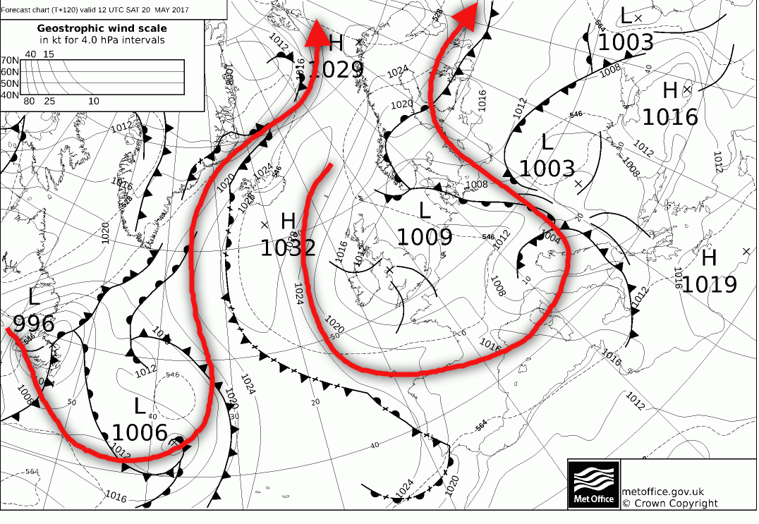
Sat 20th and Sun 21st May: Into the coming weekend and there is good model agreement from the 00Z UKMO, ECMWF, GEM and GFS for the low pressure to remain slow moving across the British Isles. As mentioned earlier in the guidance, the broader synoptic pattern is one that means not a lot of movement to the overall surface features are likely. The 120hr FAX from the UKMO model highlights the particularly messy, late Spring pattern well. Importantly from a UK’s point of view low pressure is still the dominant feature with some troughs circulating the surface low. The general jet stream location has been highlighted to continue to show the amplified and slow moving pattern.
The individual details of the weather for the weekend do remain uncertain. Given that the general synoptic pattern is very similar to that of Thursday and Friday, then the distribution of any showers over the weekend is unknown. Given slack steering flows, beneath the main surface low pressure, then regional and local convergence zones may well play a part in aligning and developing the showers. The overall consensus between the models though is still for some vigorous convection to take place each day. As a result, further moderate or locally heavy showers, perhaps with local thunder and hail are possible almost anywhere across the UK as the weekend progresses, but most likely across inland areas.
Nights will remain chilly with diurnal convection easing each evening then lead to mainly dry weather overnight with some rural frost is certainly possible too, especially across parts of the north of the UK. Maximum temperatures will remain near to average, at best, so feeling pleasant in some sunshine and the light winds, but where the showers develop then temperatures will be pegged back quite significantly.
Medium and Longer Term 22nd May onwards:
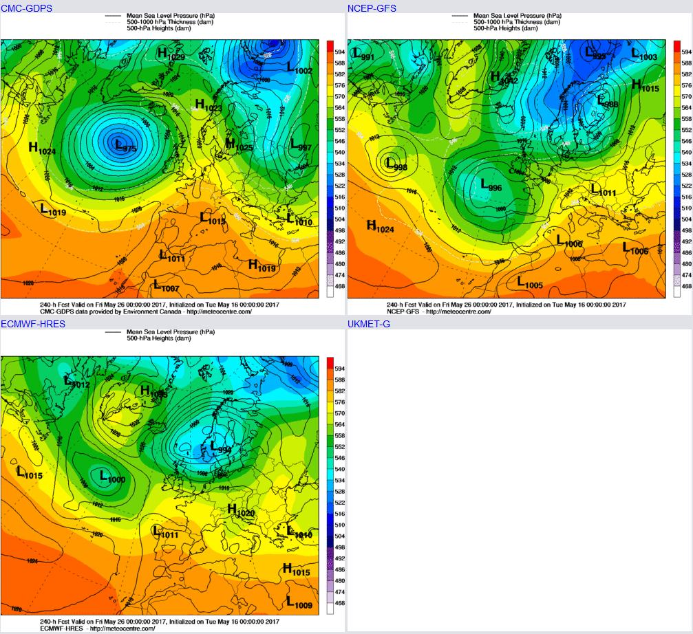
Looking further ahead, through towards the end of May and there is quite a lot of uncertainty over the broader synoptic patterns. The low surface pressure of the coming weekend is still likely to be present early next week, so further convective activity into the start of next week is forecast. However, where we go from there is uncertain. Late May and through into June is often a period of messy and rather chaotic patterns across the UK and the N Hemisphere in general, given the continued progression towards the summer time. Patterns often become buckled, blocked and irregular, just like what will happen in the coming days. Determining exactly where each trough and ridge will be is the main uncertainty. The 00Z models, out to 240hrs, have anything from a mild or warm SW’ly, of which is predominantly cyclonic from the GEM to the GFS and the ECM toying with the idea of a Greenland block and a Pm air mass, potentially even Am from the GFS.
One thing that does stand out, for now at least, is that there is little evidence, in either Deterministic or ENS models, for any early summer warmth, or hot weather in the immediate future. The remainder of May does look, overall more cyclonic than anticyclonic and with temperatures, overall, average at best.


