A wet, but mild start to the week. And the unsettled theme will continue throughout.
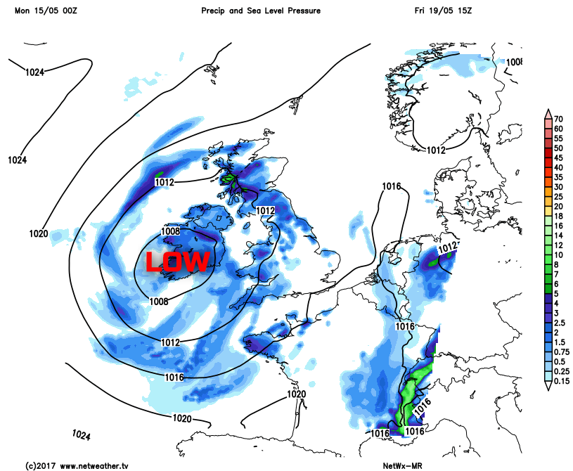
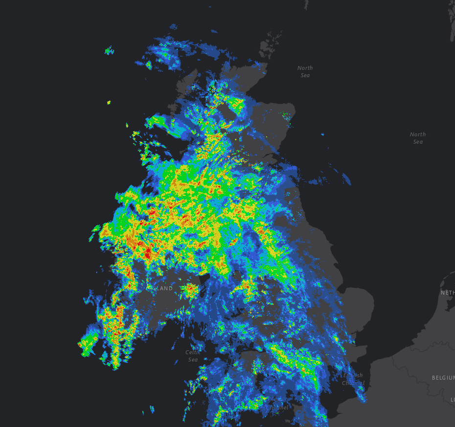
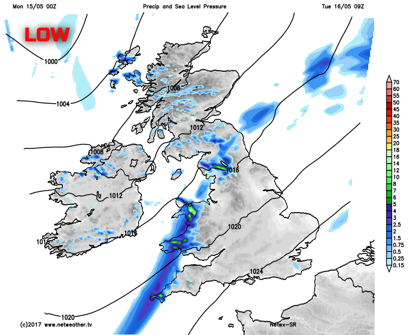
For some, it’s a welcome development, for others perhaps not so, but despite an increase in temperatures for the first half of the week, heavy rain has arrived as well. We start the working week with an area of low pressure developing to the west of the British Isles. A feed of increasingly warm and humid air, originating over more tropical waters of the mid-Atlantic will move across many areas, but along with it so will a lot of rain. Recent rainfall radar shows some widespread moderate and heavy rain across many northern and western areas of the British Isles. It's across these regions that large rainfall totals will develop.
Through the remainder of Monday and persistent outbreaks of rain and drizzle will continue across Scotland, Ireland, N England and Wales. There will be some short drier intervals, but the emphasis is most certainly on a lot of wet weather. While some rain and drizzle will extend further south-east, for southern and south-eastern areas of England, rainfall totals will be much lower than further north and west. A moderate or fresh S or SW’ly wind will also develop too across the north and west, perhaps with some extensive low cloud and hill fog as well.
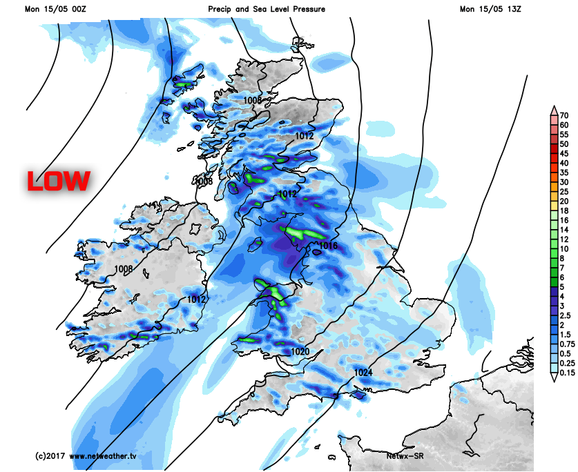
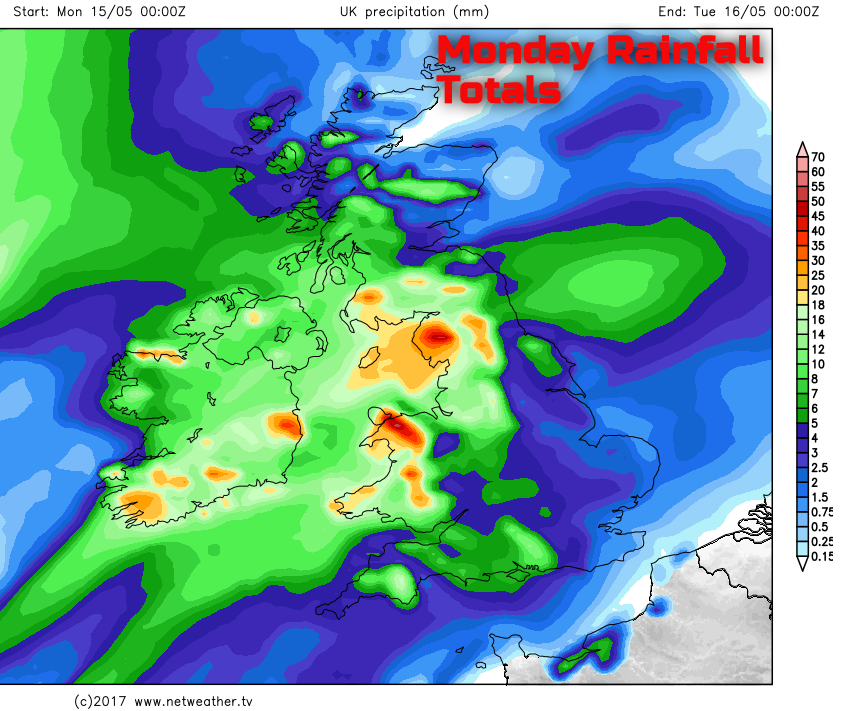
It is, however, across parts of SW Scotland, NW England and Wales where the largest rainfall totals will develop through the next 36 hours or so. Through the course of Monday up to 20mm to 30mm is likely, but perhaps up to 40mm or more across parts of Cumbria and N Wales. Fortunately given the recent dry weather then river flooding is unlikely with many tributaries likely to be able to cope with the volume of rain, but there could well be some temporary surface water flooding and perhaps some poor driving conditions as well.
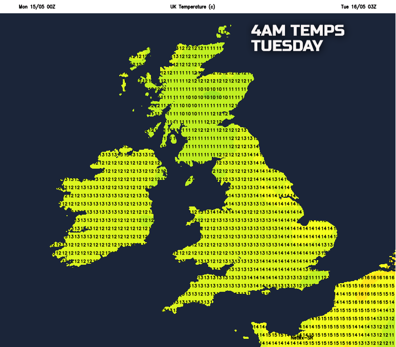
Temperatures will rise as the day progresses from the south-west with the maximum temperatures today occurring towards the end of the afternoon and into the evening. Temperatures will rise to 16C or 17C across England and Wales, and around 14C to 16C across Scotland and Ireland. There will also be an increasingly humid feel to the weather, especially across England and Wales. After some chilly nights in recent weeks, tonight will then be a very mild, if not warm night, with minimum temperatures no lower than 12C or 13C. Perhaps falling no lower than 14C or 15C in towns and cities.
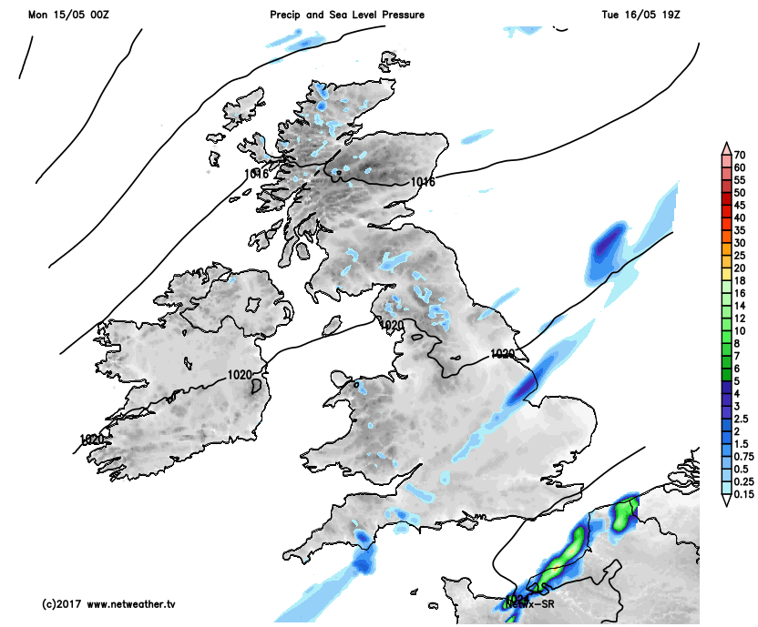
Through Tuesday and further spells of rain and drizzle will continue to affect many northern and western areas through the day with the rainfall totals for some areas continuing to increase. As the day progresses, the wet weather will steadily progress towards the south-east. With then drier and sunnier conditions spreading from the west, with much of Scotland, Ireland, N England and Wales ending the day with much better weather than the way the day is forecast to start.
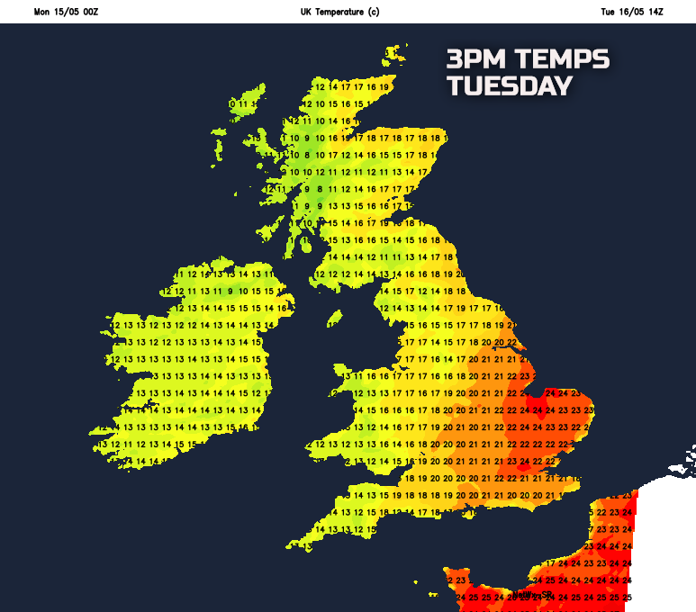
A very warm day is possible on Tuesday, especially in England and Wales before cooler and fresher conditions arrive from the west later. Temperatures across E Anglia and SE England may well reach 22C or 23C, for a time, during the early afternoon. But this will be dependent on some sunshine and whether a weather front remains to the west of the region, allowing temperatures to rise.
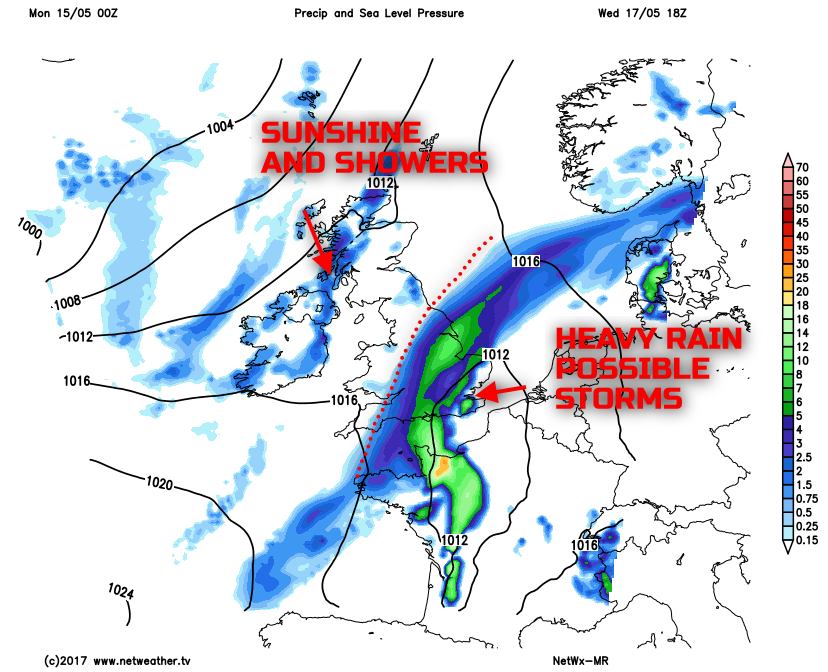
Looking further ahead, through the rest of the week and the unsettled conditions are set to continue. Attention turns towards SE England on Wednesday when the risk of some heavy rain develops here, potentially with some local downpours and thunderstorms too later on in the day. Some locally large rainfall totals are possible, perhaps bringing some poor driving conditions and even some temporary surface water flooding too. Something we will be keeping a close eye on in the next few days. Elsewhere a mixture of the sunshine and scattered showers are expected but compared with earlier in the week then conditions will be far better on Wednesday across the north and west.
The working week is expected to end with a mixture of sunshine and showers. A cooler and fresher end of the week is forecast too with temperatures several degrees lower on Thursday and Friday than compared with Tuesday for example. Low pressure is likely to drift into the UK, from the west bringing the risk of showers, perhaps with some locally heavy and thundery by Friday.