Changes Ahead As Cyclonic Weather Arrives.
Issued at 1500BST on Tue 9th May based on Tue 9th May 00Z Model Runs
Key Points
Discussion:
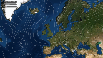
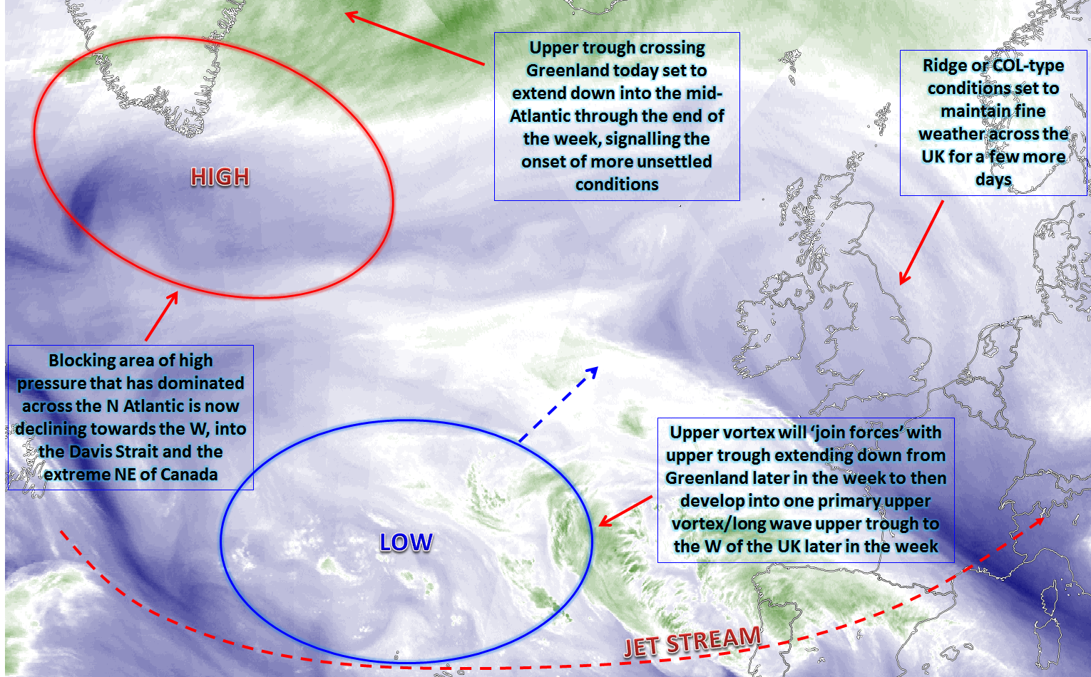
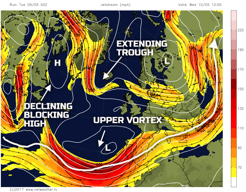
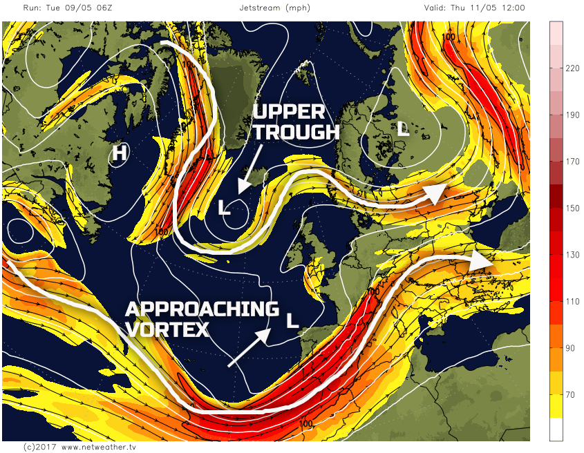
Wed 9th May: Into Wednesday and the broader weather patterns across the N Atlantic will be undergoing some significant changes. A large blocking area of high pressure that has dominated to the N of the UK is now retrogressing and will become located in the Davis Strait and the extreme NE of Canada through Wednesday. At the same time, a large-scale vortex situated to the SW of the UK will remain influential, bringing some particularly unsettled conditions into Iberia. Importantly as well is the development of an upper trough out of Greenland, to the NW of the UK through the day. The ECMWF, UKMO, GFS and GEM all pick up on this extending upper trough and it is this feature, combined with the already existing vortex to the SW, which will signal a large-scale change in the weather patterns across the N Atlantic. The features above are highlighted well by the 00Z GFS model for 12Z on Wednesday.
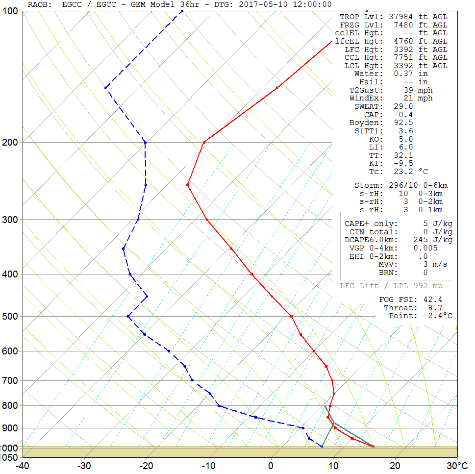
While these broader changes take place, the weather across the UK will remain benign. Wednesday could well be one of the best, if not the best day of the week. Model guidance signals a lot of clear skies across the country through the course of the day, in association with a forecasted dry atmosphere. The forecast sounding for Manchester, below, highlights this well. The significant difference between the blue hashed line (dew point) and the red line (environmental temperature) means dry air and low RH readings throughout a large portion of the atmosphere. Except for a few well-scattered Cu clouds, then, overall, many areas of the UK will have plenty of unbroken sunshine through Wednesday, and when coupled with light winds it will end up being pleasantly warm too.
The one exception to this could well be across the north of Scotland. The approach of a frontal zone may well mean thicker cloud, perhaps along with some patchy rain or showers across the extreme N of Scotland. Clearly, though, this will be the exception to the rule, and, for many a glorious day is expected.
Thu 10th May: As we move into Thursday and this is when the progression towards more unsettled conditions begins to develop. For much of the day though the dry weather will continue with some bright or sunny spells too, especially across more northern and western areas of the UK. In comparison to Wednesday though, many areas will have more cloud around. As the day progresses the upper vortex to the SW will approach from the SW, while at the same time the extending upper trough to the NW will become more pronounced and will be directly associated with a low surface pressure. What this means is that the overall weather pattern across the British Isles, and NW Europe in general, will be one that is far more cyclonic than anticyclonic like of late.
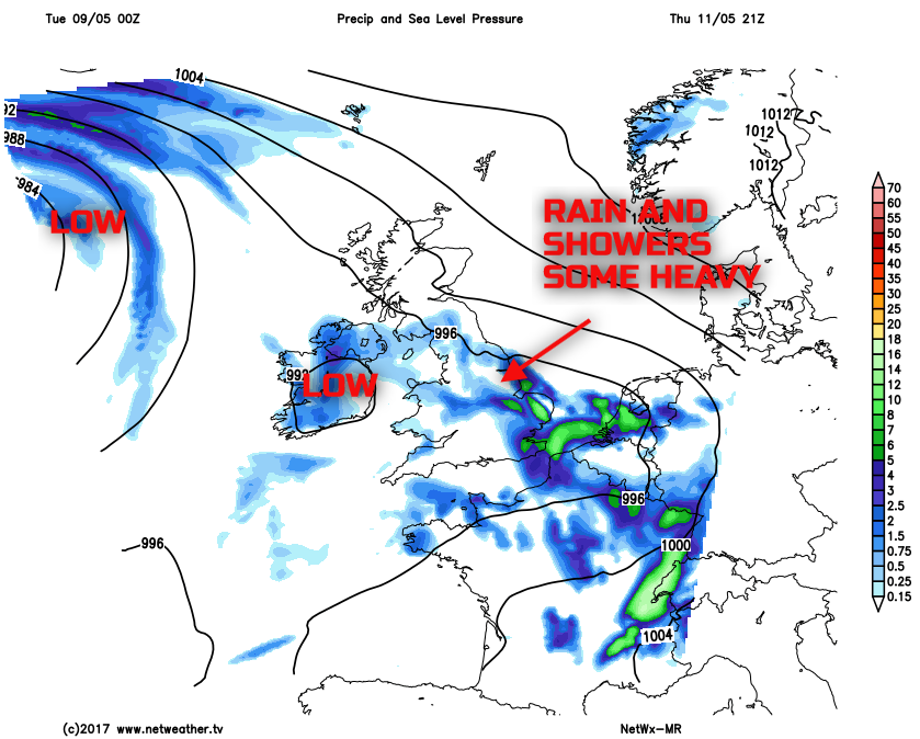
Through the second half of Thursday and then particularly into Thursday night, baroclinic features will move into many S areas of the British Isles. Showers and longer spells of rain will then develop, perhaps some heavy precipitation to and embedded convection isn’t out of the question given some evidence of instability. This risk of rain and showers, the first appreciable rainfall in weeks for some areas of England and Wales, will then move northwards across most areas into the early hours of Friday. Our MR model is doing a reasonable job of highlighting this development.
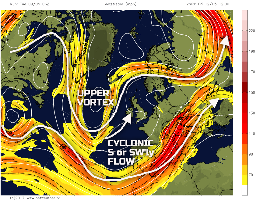
Fri 11th May: We end the working week with the ECMWF, GFS, ECMWF and the GEM GM’s all in decent agreement over the extensive development of a broad longwave upper trough within the N Atlantic. It is this feature that will then drive the more cyclonic events to end the week and also continue into the coming weekend too. The 00Z GFS highlights this broader pattern well.
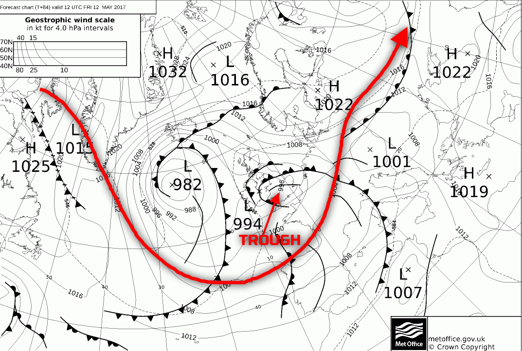
It is expected to be a wet start to the day across much of England, Wales and Ireland. The precipitation is likely to be quite sporadic though, especially if a convective element has indeed developed. As a result, while some areas will likely have rain and showers, there will be temporary drier and brighter intervals too. It is likely as well that N Scotland will be the last to see any wet weather, perhaps not arriving here until the middle and latter half of the day. The synoptic developments during the day are driven by a low surface pressure and its associated frontal zones, but also with the potential for convective release through the afternoon. As the more dynamic frontal cloud and precipitation drift northwards, some cloud breaks developing across central, southern and eastern areas of England will allow surface temperatures to rise and thus create a potentially unstable atmosphere. This risk is highlighted on the 00Z UKMO FAX for 1200Z on Friday by the trough behind the occlusion through central areas of England.
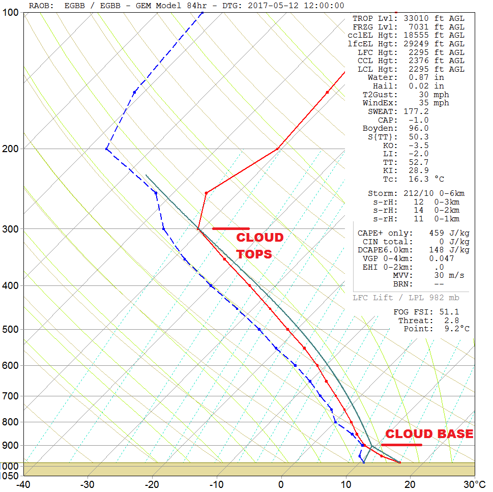
The forecast sounding for Birmingham at around noon on Friday highlights this convective threat particularly well. With a surface temperature of around +16C and a dew point of near +10C, both of which are achievable, then the atmosphere does become completely unstable. Forecast CAPE values near 400j/kg to 500j/kg seem reasonable, with cloud tops potentially up to near 300mb, or around 28,000ft. While the details of this more mesoscale development are somewhat uncertain at this range, it is prudent to highlight that Friday afternoon could well produce some heavy downpours and local thunderstorms across some central, southern and eastern areas of England.
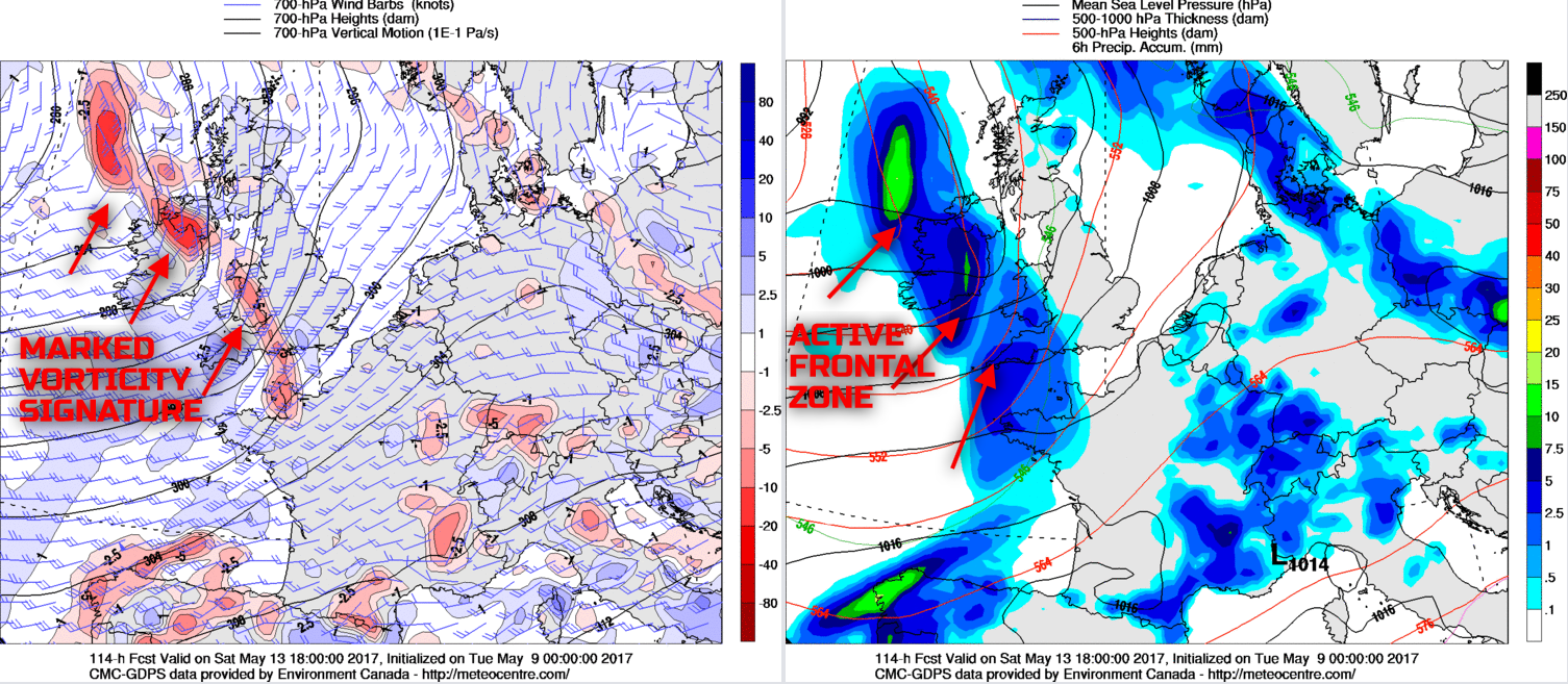
Sat 12th and Sun 13th May: So, we progress into the coming weekend with a cyclonic weather pattern dominating across the British Isles and the N Atlantic, a marked changed than compared with of late. There are certainly some uncertainties over the details for the weekend at this range, given some baroclinic features may well develop. However, firstly looking at Saturday and it is likely that a mixture of sunshine and showers will be in evidence during the day, these perhaps most prevalent across the N of the UK. There will be some lengthy drier and brighter intervals in-between, maybe even some sunshine too. However, the 00Z models are in reasonable agreement for a frontal zone to move into the UK from the W and SW through the afternoon and into the evening. This feature does look well forced with some marked vorticity associated with it, and, as a result, the precipitation could well be well organised and locally heavy.
The 00Z GEM model highlights this feature well, also with the general mixture of sunshine and some showers ahead of it. The timing of the more persistent frontal rain is uncertain, but it is likely to move into Ireland, Wales and SW England through the afternoon before then sweeping N and E into the overnight period.
Into Sunday and the overnight frontal zone could well still be in evidence across some N and E areas first thing, but this is then clearing away. What follows is rather uncertain, but the overall pattern is always more cyclonic further N and W, so Scotland and Ireland could well see sunshine and showers through Sunday, perhaps with some longer spells of rain. In contrast, England and Wales may well see a slight rise in pressure from the S and SW, so more of a fair weather day here with some sunshine, pleasant temperatures and just with a few scattered showers.
Temperatures through the remainder of the week and into the weekend will recover to become near the mid-May average across most areas. This general rise in temperatures will be in association with the development of a warmer air mass from the S and SW, in conjunction with the upper vortex to the W. Importantly as well will be a rise in minimum temperatures. There have been some unusually chilly nights of late, but from Thursday and Friday onwards then minimum temperatures will be well above freezing, remaining into ‘double figures’ across towns and cities potentially too.
Medium and Longer Term 14th May onwards:
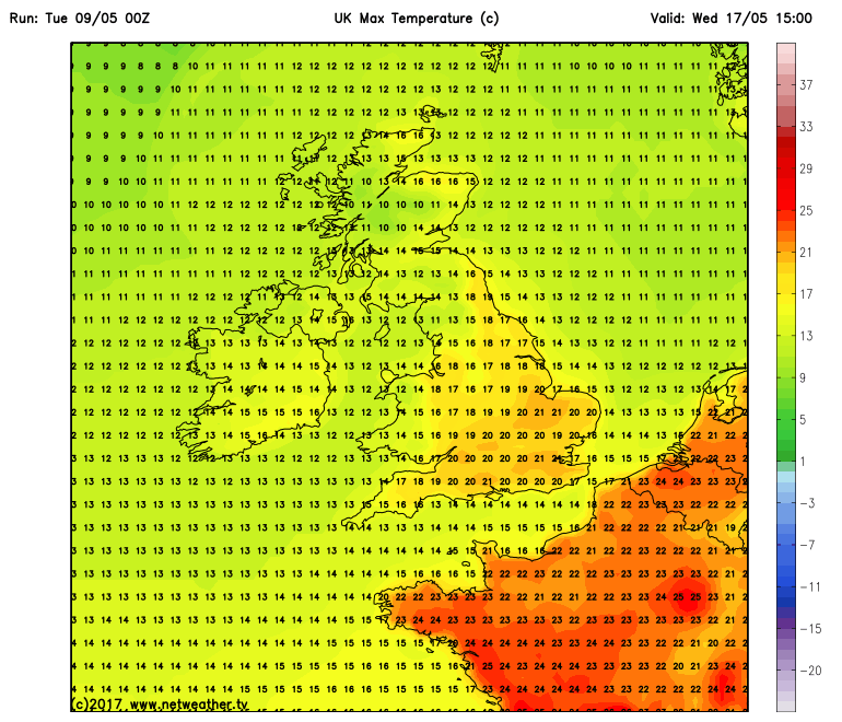
Looking further ahead towards and beyond the middle of May and, overall, the more cyclonic and changeable weather patterns will likely continue. The persistent blocking regime that has dominated, overall, for some weeks with quite a record low –ve NAO regime, is unlikely to return. There may well be a temporary rise in temperatures too during the early part of next week. The upper vortex to the W may well back the flow more to the S or SW, and this could well signal some warm or very warm conditions across parts of England and Wales, as exampled by the 00Z GFS.
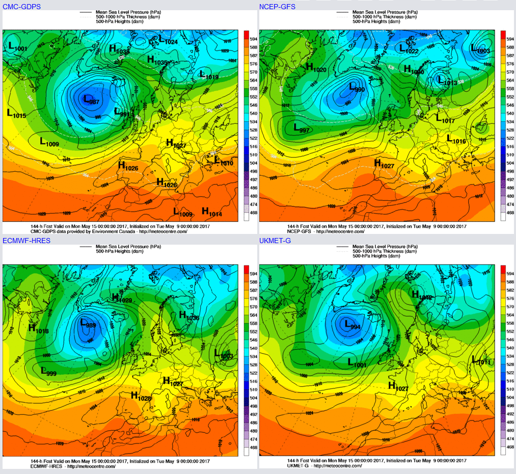
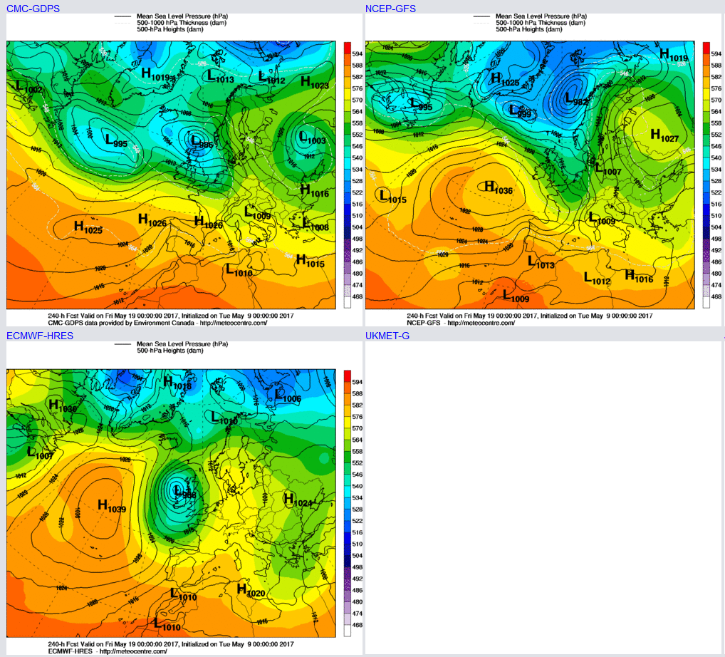
This warmth that is likely to be short-lived as, overall, there is a reasonable model agreement for the pattern to become somewhat more progressive and the upper vortex, and low surface pressure to the W, to potentially move into the UK by the middle and latter half of next week. This more changeable and mobile evolution creates uncertainty over the forecast but taking the 00Z GEM, ECMWF and GFS for T+240hrs as a guide, then the weather across the UK is far more cyclonic than anticyclonic. The ECMWF and GEM in particular both having noteworthy areas of low pressure with possible high winds and heavy rain too.
So, for many regions of the UK, the prolonged period of benign and dry weather conditions stretching way back in April and, for some, even further back than this is coming to an end in the coming days. While not a washout for all, there is clear evidence that the first appreciable rainfall is on the way and, overall, a quick return to a more settled regime seems particularly unlikely at the moment.