Blocked weather pattern continuing to dominate the UK's weather.
Issued at 1500BST on Tue 2nd May based on Tue 2nd May 00Z Model Runs
Key Points
Discussion:
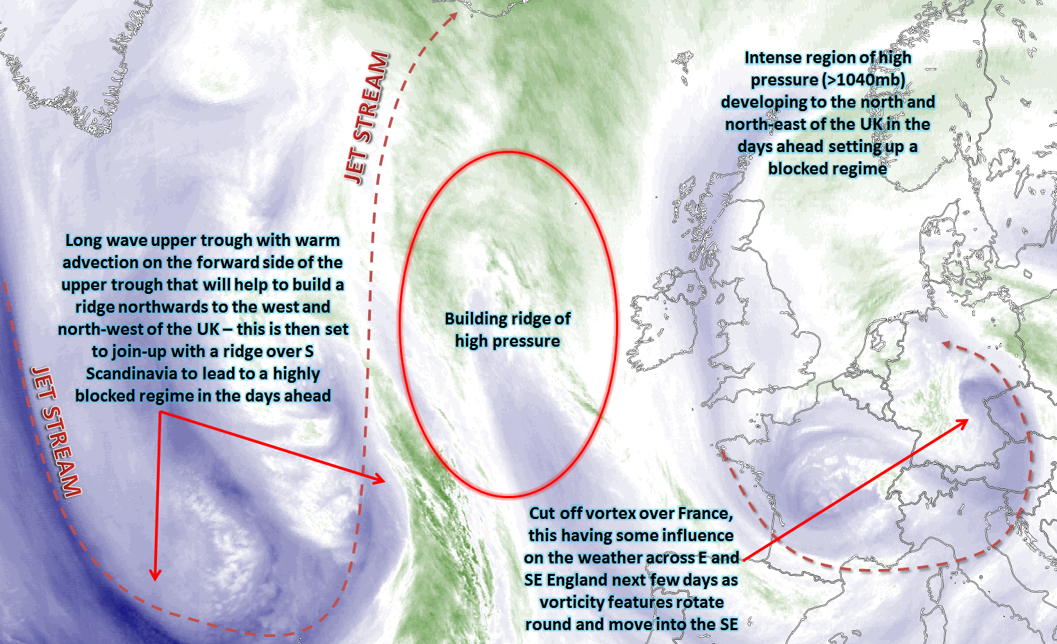
Wed 3rd May: Into Wednesday and the two primary features of interest across the N Atlantic and into Europe are that of a long wave upper trough over the North Atlantic and a developing large area of high pressure over Scandinavia. The long wave upper trough, in prior days, will have helped to build a ridge northwards to ‘join forces’ with a ridge over Scandinavia to then develop the main surface and upper blocking high pressure. The WAA (warm air advection) on the forward side of the long wave trough is one of the primary reasons GPH (Geopotential Heights) increases and that process has been in evidence over the last day or so. There is, however, a weakening upper vortex just to the SE of England, this will continue to have some mesoscale influence on the weather across more southern and south-eastern areas of England.
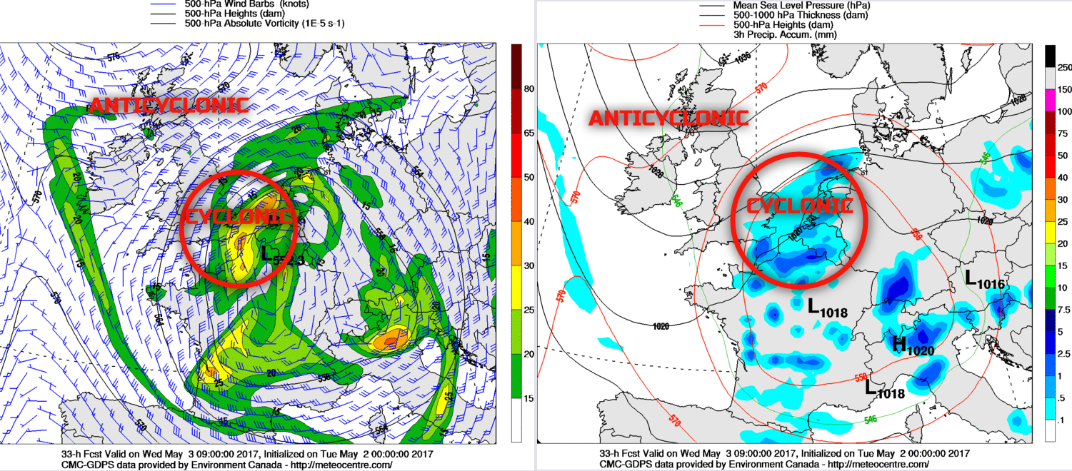
Through the course of Wednesday and the developing surface and upper-level anticyclone will ensure the majority of the British Isles is dry and settled. Many areas of Scotland, Ireland and N England will have plenty of sunshine, prolonged spells of sunshine in fact in association with anticyclonic conditions. However, many central, southern and south-eastern areas of England will have more cloud, primarily due to a region of vorticity and a more cyclonic pattern that will be moving in from the E during the day. The 00Z GEM model gives a good representation of this feature. What it will do is create far more cloud across the areas mentioned above through the day and also perhaps bring some nuisance value light rain or showers to SE England in particular.
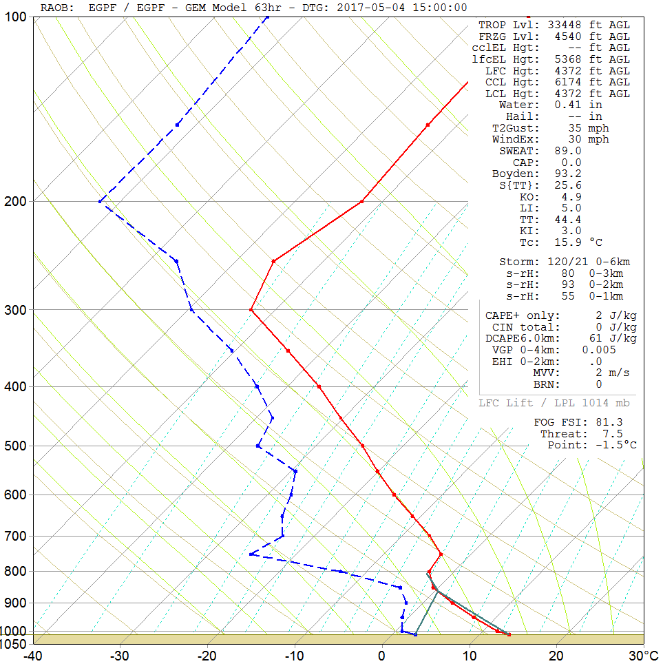
Thu 4th May: As we progress into Thursday and, once again, there will continue to be quite a distinct difference in conditions across the UK, despite what is a full progression towards more settled weather. The main surface blocking high pressure will remain slow moving (quasi-stationary) to the N of the UK. The high will continue to maintain excellent weather across many northern and western areas, with further spells of sunshine across Scotland, Ireland and N England. The forecast sounding for Glasgow on Thursday afternoon shows a dry atmospheric profile. There may well be some high based Cu clouds developing through the day, but otherwise, a lot of cloud-free skies are likely. There will, however, be a noticeable breeze from the E, especially to the W of higher ground where it could be quite gusty.
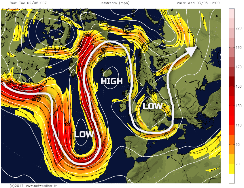
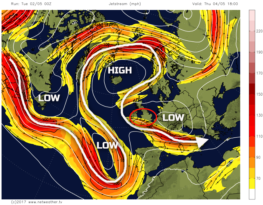
Across many central and southern areas of England and Wales and the remnants of Wednesday’s vorticity continues to be a feature of the weather, extending westwards through the day. The region of interest can be seen, as highlighted, on the jet stream chart and associated isobars, noting a westwards extension of the central vortex located just to the SE.
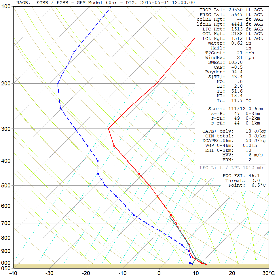
Using a forecast sounding for Birmingham as an example, it clearly shows far more moisture within the mid and lower levels of the atmosphere, then compared with the sounding from Glasgow, of which will leads to the forecast that at a lot more cloud will be present. The cloud is likely to be thick enough to for some patchy light rain or showers moving westwards.
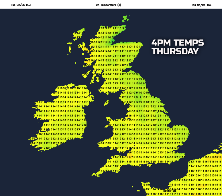
The combination of an intense (>1040mb) anticyclone to the N of the UK and a more cyclonic flow to the S and SE, means there will also be a tight pressure gradient across the UK and hence a windy day is expected. A chilly E or NE’ly breeze is expected for some areas, particularly those adjacent to the N Sea. Our MR weather model highlights this, with some coastal areas of E England having temperatures no higher than 9C to 11C on Thursday afternoon. In contrast though, across more northern and western areas, in some sunshine, then temperatures of 13C to 15C will feel pleasant enough.
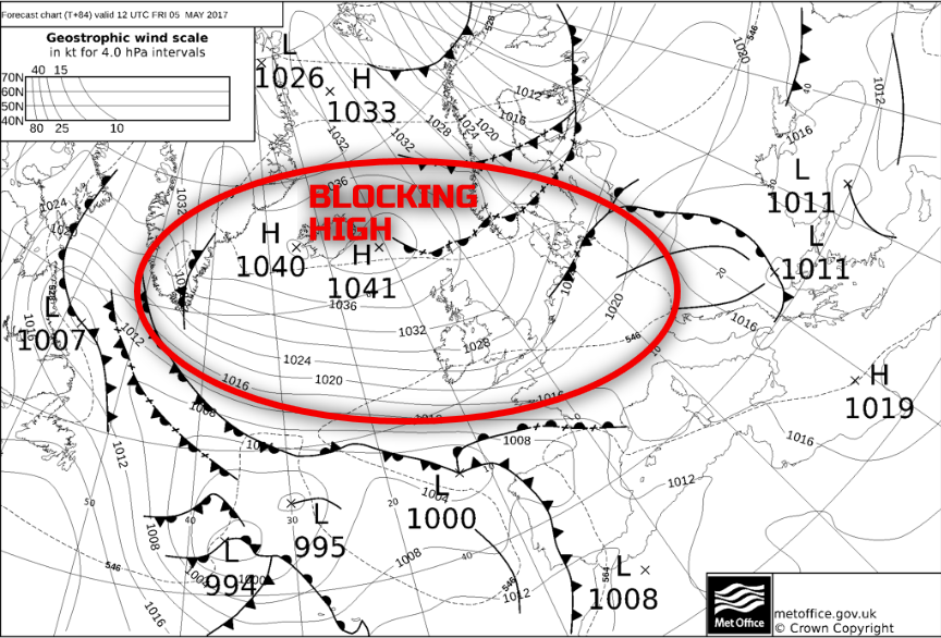
Fri 5th May: We end the working week with a good model agreement between the GM’s (UKMO, GFS, ECMWF and GEM) for the high pressure to continue to be the dominant feature of the weather. Any forcing and vorticity across more central and southern areas of the British Isles will have cleared, as things stand, and most areas of the UK will have a dry and benign day of weather. The strong E or SE’ly wind will, however, continue and this will maintain a cooler feel to the weather across areas nearest to the North Sea. The consensus to is that most of Scotland, Ireland and N England, especially western regions, will have the best of sunshine still, whereas further S and E, then more cloud is likely to develop through the day. The overall synoptic pattern for the end of the week is highlighted well the 00Z T+84hr FAX from the UKMO, noting the large and dominant anticyclone just to the N.
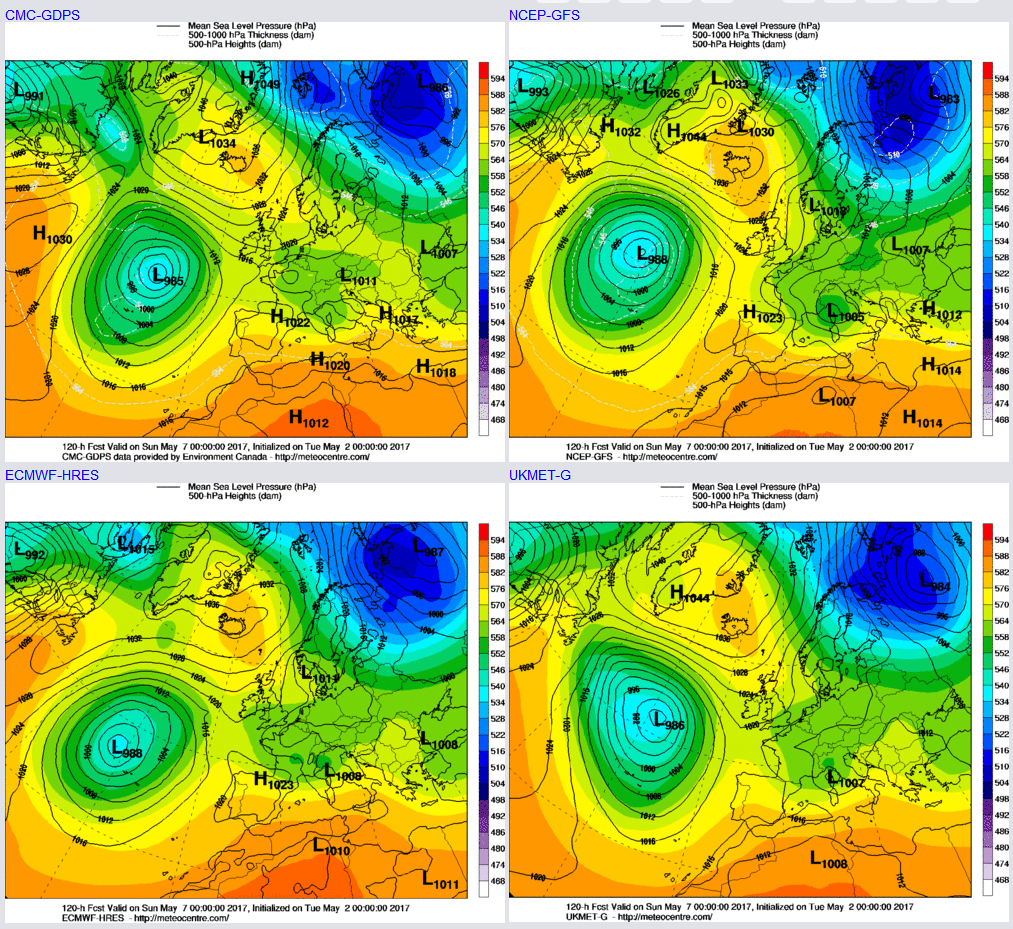
Sat 6th and Sun 7th May: Into the coming weekend and there remains good model agreement, and consistency over the broader synoptic pattern with further settled conditions dominating across many areas. There is a model-wide agreement for high pressure to remain dominant to the N and NW of the UK, while lower pressure develops to the SW, creating a –ve NAO (North Atlantic Oscillation) pattern. While there are some uncertainties over the details, particularly regarding clouds amounts and distribution, confidence is high to suggest many areas will remain dry with bright or sunny spells and variable cloud. There may be some increase in the cloud across more eastern areas of the British Isles, perhaps especially along eastern coastal counties with some patchy light rain or drizzle here, but this will be an exception to the general rule. The other feature in evidence to is the overall pressure gradient across the UK will not be as intense as previous days. As a result, winds are likely to become lighter as the weekend progresses and with some evidence of WAA (Warm Air Advection) from the NE then temperatures may well rise further through the weekend. The 00Z UKMO, GFS, GEM and ECMWF all highlight this general synoptic pattern well.
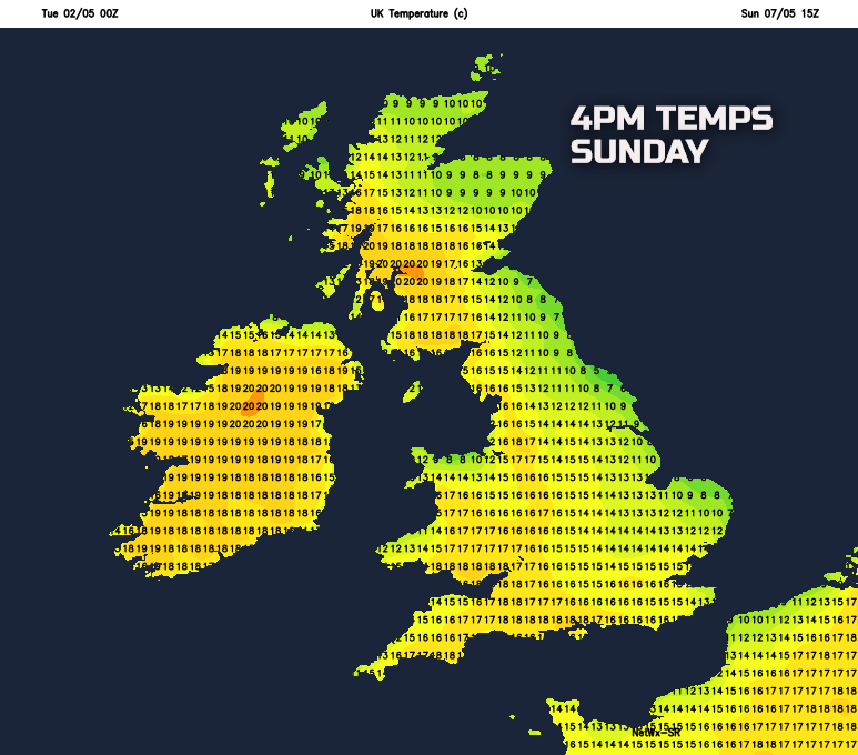
Some chilly nights may well be possible into the weekend though, primarily in association with a reduction in wind speed. However, as our current MR model highlights by Sunday, some northern and western areas of the UK, especially to the W of high ground, could have temperatures up to 18C to 20C. Some favoured locations could be W and SW Scotland, Ireland in general, NW England, Wales and SW England too. As a result, the current summary for the weekend is for settled and pleasantly warm conditions for most with lighter winds than previous days.
Medium and Longer Term 8th May onwards:
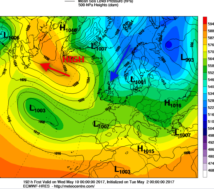
Looking further ahead into the second week of May and beyond and there is some increasing consistency within the forecast models, especially the ENS for a more unsettled and cooler pattern to develop. In what could well be quite a change in weather when compared with the opening week of May, the signals at the moment point towards a reduction in GPH across the British Isles and also with the potential development of an N or NE’ly flow too. Using the 00Z ECMWF as an example, the current thinking is the high pressure will begin to retrogress (move westwards) towards Greenland and perhaps parts of NE Canada. As this process takes place, then there is the potential opportunity of a drop in temperatures from the N and NE, with much cooler, if not quite cold conditions developing. Something thing to keep an eye out for within the weather models moving forward, from around the 9th and 10th onwards.
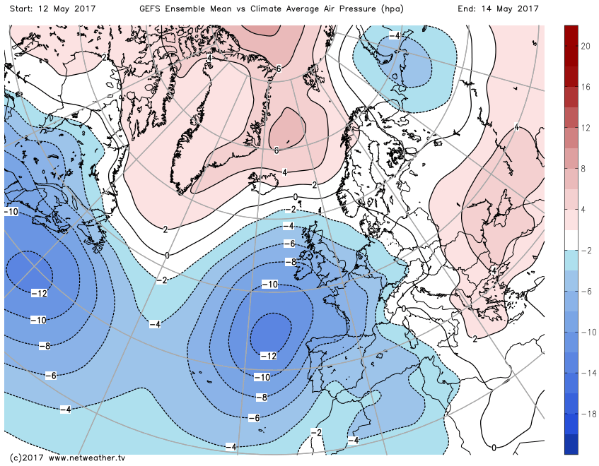
Beyond this period, towards mid-month or so and the overall consensus is for low pressure and unsettled conditions to become established across all areas of the British Isles. The 00Z GEFS ENS Mean v Climate Average Air Pressure (hPa), clearly shows a –ve anomaly regarding pressure across the UK and to the SW. So, while the opening week or so of May is likely to produce some very pleasant weather, as the month of May progresses then a far more unsettled and cooler period of weather is most likely at the moment.