Latest synoptic guidance blog.
Issued at 1500BST on Tue 18th April based on Tue 18th April 00Z Model Runs
Key Points
.png)
Discussion:
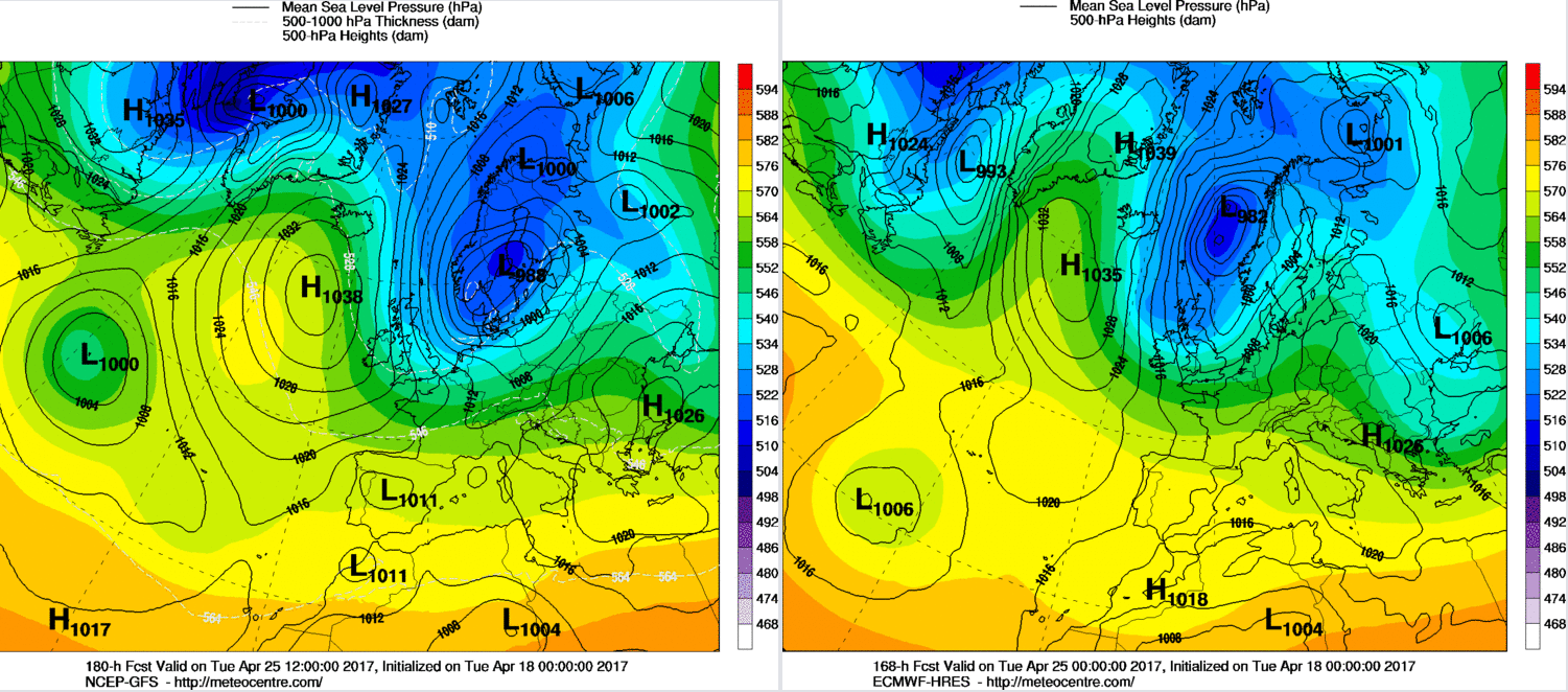
Wed 19th and Thu 20th Apr: The broader synoptic pattern across the UK and NW Europe, in general, is being dominated by a blocking regime. April is often a month when blocking patterns can materialise and also be quite persistent, this year providing a good example of that. Within the last week or two, the final warming of the stratospheric polar vortex has taken place and that too can and will have helped to reinforce a more meridional pattern across the northern hemisphere and aided in maintaining the blocking regime. Through Wednesday and Thursday and a large anticyclone will dominate across the UK, NW Europe and even across the N Atlantic. The main PFJ remains well to the north of the UK and will continue to do so, while a large-scale upper vortex brings unsettled weather to more central and southern areas of Europe. This general blocking regime, with a N’ly tracking jet, is highlighted well on the 00Z GFS model.
.png)
The position of the block though means that a general flow off the N Atlantic is likely across more northern areas of the UK, while the main centre of gravity of the high is always across more southern areas of England and Wales. With the main PFJ tracking to the north of the UK then this allows weak, frontalysing frontal zones to move down into the UK over the top of the high pressure. As a result through both Wednesday and Thursday, a general north and south divide in conditions is expected to develop. The usual uncertainty is over cloud amounts, especially how much low level, ScCu type cloud filters down across the UK. What does have high confidence though is that Scotland, Ireland, and N England will see more cloud than elsewhere and this cloud will be thick enough at times, especially across western facing hills, to produce some nuisance-value light rain and drizzle. Across many central and southern areas of England and Wales though the dry weather of the last week or more, will continue.
Highlighting this evolution well is the two forecast soundings below. The first one is for Glasgow, a good representation of more northern areas of the UK. Note beneath approximately 750mb the dew point (blue dashed line), and the atmospheric temperature (red line) are, essentially, next to each other. This highlights a highly saturated atmosphere. The resultant surface weather would be overcast, with the risk of some mainly light rain or drizzle and, again, this overall evolution highlights the weather across more northern areas in the next few days. Clearly to the east of high ground then some fohn effects may well come into play so that it won’t be completely overcast for all of the north, there will be some brighter intervals more locally.
.png)
Now, in contrast, is the forecast sounding for London at 1200Z on the 19th. Note a marked region of subsidence and a very dry layer between 700mb and 800mb. Not only that, the lower layers (900mb and below) of the atmosphere are far drier than compared with the sounding for Glasgow. Note also the difference in dew point and temperatures within the boundary layer. Some fair weather Cu clouds will result, perhaps along with some upper-level CiCs cloud as well, but overall, compared with the north, this highlights a far drier atmosphere with more clouds and more sunshine.
.png)
Fri 21st Apr: As we move into Friday and there is some good model agreement between the ECMWF, UKMO, GFS and GEM GM’s, for example, for some type of retrogression. The main surface high pressure is likely to become located more towards the W and, eventually, towards the NW of the UK, while a large area of low pressure dominates over Scandinavia. This resultant pattern means that a weak cold front, associated with the large area of low pressure over Scandinavia, will move southwards across the UK re-introducing a cool, or cold, Pm or even Am air mass, especially across the north of the UK. This general pattern is highlighted well on the 00Z UKMO FAX chart for 12Z on Fri 21st. Clearly note that the high pressure’s CoG is beginning to be ‘pulled’ more towards the W of the UK, while a large low pressure dominates over Scandinavia. The resultant weather through the day will be for many central and southern areas of England to maintain very pleasant conditions, with dry weather prevailing along with some sunshine. Further N though the cold front will signal a cloudier day with some patchy rain and showers moving southwards. The cold front will be particularly weak, with little forcing associated with it, but it will still do its job of introducing a colder air mass behind it, despite a lack of any significant precipitation.
.png)
Sat 22nd and Sun 23rd Apr: So, we move into the coming weekend, and all the main GM’s (UKMO, ECMWF, GEM, and GFS) are in good agreement for an anticyclonic Pm N or NW’ly air mass to be in evidence over the UK. As a result, a cold start to Saturday is expected, especially across northern areas of the UK with a likely frost. The overall weather for Saturday itself though is still one that lacks any significance. Despite this shift in the main CoG of the high pressure more to the W and NW of the UK, along with a change in air mass, the overall pattern remains anticyclonic. As a result, many areas of the UK will have a dry day on Saturday with bright or sunny spells and probably fair weather Cu cloud that will develop inland through the day due to surface heating. The overall flow will, however, be more cyclonic across some parts of Scotland and perhaps E England and it is here that some scattered showers may well be possible through the day, potentially wintry on higher ground as well. Our 00Z MR weather model highlights the general pattern well and clearly note most of the UK is still expected to have atmospheric pressure at or above 1030mb, especially across more western areas. The model does highlight some showers across the N and E of the UK, and that is accepted, for the reasons just discussed.
.png)
As we move through into Sunday and this when some model divergence begins to appear. After what is likely to be another chilly or rather cold night on Saturday night with a likely frost, rurally at least, another dry day is currently expected on Sunday for many areas of England, Wales, and Ireland. However, there is now evidence for some cyclonic development near Iceland as Sunday progresses, directly associated with a short-wave trough coming S out of Greenland. This may well introduce more unsettled conditions across the N of the UK by the end of the weekend with some wet and windy weather potentially getting into Scotland, at least, by the end of the day. The timing of this feature from the NW will be crucial as to how quickly the weather will break down during the second half of the weekend, and this is the main uncertainty. Clearly if this developing low, exampled on the below GM’s, arrives sooner the second half of Sunday for many northern areas of the UK could well become more unsettled.
.png)
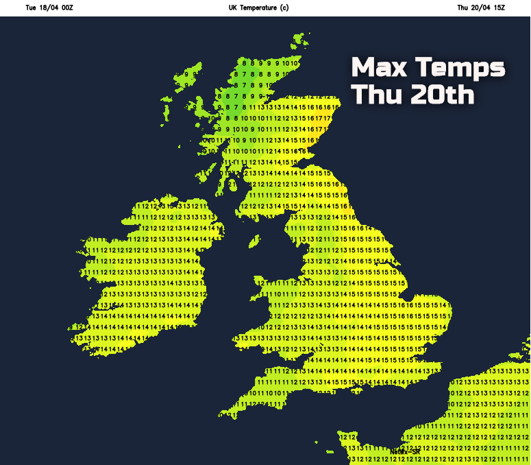
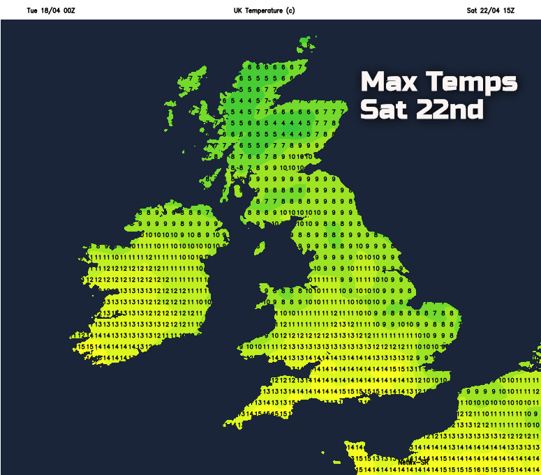
Temperatures over the coming days will fluctuate, as they can often do at this time of year. Giving an example of this is the expected maximum temperatures on Thursday, which will lead to a very pleasant day, especially in the increasingly strong April sunshine. But then, in contrast, is yet another cool or cold day, on Saturday. Overnight frosts will also return from Friday night onwards too, something for gardeners and growers to be aware of in particular.
Medium and Longer Term 24th onwards:
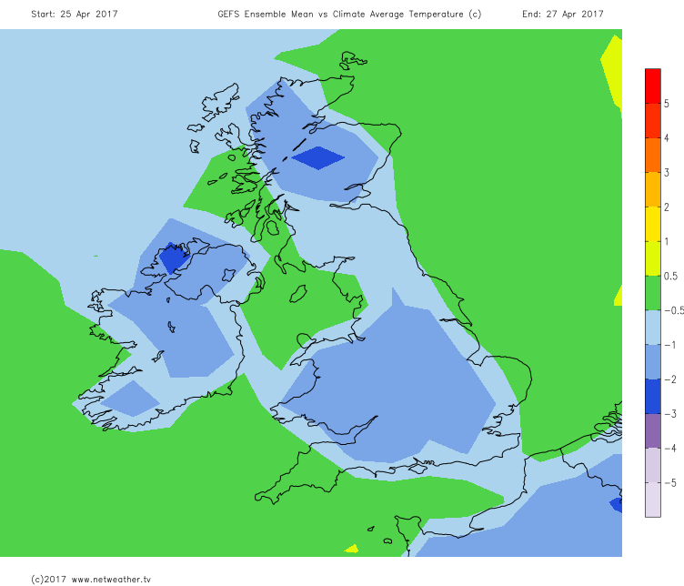
From around the 24th onwards, the important development is the area of low pressure that is forecast to approach from the NW at the end of the coming weekend, so through the 23rd. This low pressure is set to bring a more cyclonic period of weather across the UK into the beginning of next week, and there is quite high confidence over this evolution. Equally with the main area of high pressure still to the W and NW of the UK, then the developing low will combine with the high pressure to bring a more pronounced surge of cold air southwards across the UK through the 24th and the 25th, with a potential direct Am air mass affecting the UK. As a result, confidence is increasing, given good ENS support too, for next week to maintain quite cold conditions for late April, but this being accentuated more given that high pressure will be replaced by a more cyclonic N or NW’ly flow. The 00Z GEM model may well be something of an outlier, given ENS analysis, but using the 00Z GFS and the 00Z ECMWF as a guide, you can clearly see a particularly cold, cyclonic N or NW’ly flow would dominate across the UK.
So, in summary, the final week or so of April is likely to be dominated by below average temperatures and perhaps, especially across the northern half of the UK, some particularly late winter type weather. Overnight frosts could well be more frequent than normal for late April, and some wintry precipitation would be possible, and not just on the high ground either, depending on the details. With lower pressure more influential too, then this would also mean rainfall, totals will be more pronounced than of late and with a possible fresh or strong N or NW’ly wind too, at least for a time, it may well not feel very much like late April at all as next week progresses.