Latest synoptic guidance as a less settled spell gets underway.
Issued at 1500GMT on Tuesday 14th Mar based on 14th Mar 00Z Model Runs
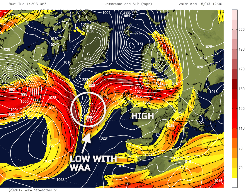
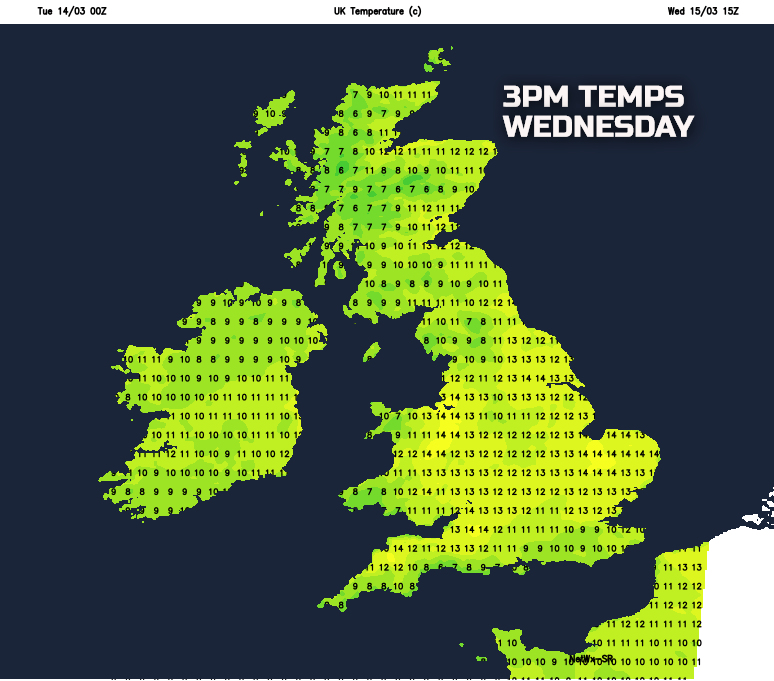
Wed 15th Mar: Into Wednesday and, overall, the pattern across most of the UK remains anticyclonic as the jet stream continues to track to the north of the UK. A rapidly developing area of low pressure, within the N Atlantic, will track to the NW of the UK through the course of the day, its warm front moving across more northern and western areas, whilst WAA on the eastern flank of the low helps to maintain anticyclonic conditions across most areas of the UK. The UKMO, ECMWF, GEM, GFS, ARPEGE, JMA and all HRES models are in good agreement regarding this synoptic evolution through the course of the day. The GFS model is used below as an example of the overall synoptic pattern.
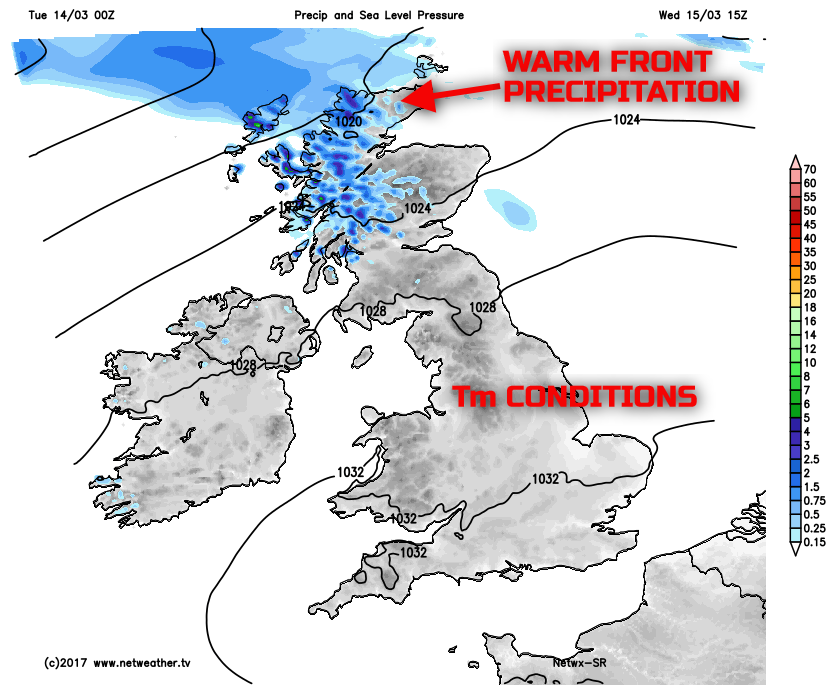
The weather, as a result, will be more unsettled across parts of the N and W of the UK, so mainly across Scotland and Ireland. Here warm frontal conditions will dominate through the day with some mostly light rain and drizzle moving north-eastwards, especially affecting western hills of W Scotland through the day. Som extensive low cloud and hill fog are to be expected as well. Across England and Wales, all the main HRES models indicate predominantly dry weather throughout the day, but forecast soundings do show quite a lot of moisture within the boundary later. This means that quite extensive Sc or ScCu type cloud is possible during the day, despite some cloud breaks, especially to the east of high ground. Clearly with WAA occurring over the UK, in association with the low pressure to the west, then a mild and moist Tm air mass dominates so another very mild day is expected, locally warm where any sunshine does break through the relatively shallow boundary layer cloud.
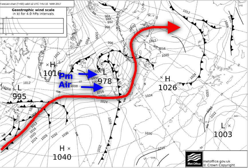
Thu 16th Mar: As we move into Thursday and the low pressure that will be to the W of the UK during Wednesday is forecast to track to the N of the UK through the course of the day. The jet stream pattern will begin to change, and a short-wave upper-level trough will accompany a cold front across the UK through the day, but with the forcing associated with the trough generally weak and not well aligned with the surface cold front. Equally, there will also be a drop in thicknesses and 850mb temperatures from the W and NW, through the day, so behind the cold front, a drop in temperature is expected, especially across northern and western areas of the UK. Ahead of the cold front and further anticyclonic conditions with relatively high GPH will dominate across England and Wales so another fine day overall with some bright or sunny spells too. Showers and longer spells of rain will develop across Scotland and Ireland, this accompanied by a fresh or strong W or SW’ly wind too, veering more NW’ly later. The UKMO FAX charts highlight the evolution well through the course of Thursday, with all the main GM’s and HRES models too generally in good agreement. It should be highlighted though that there is some uncertainty over the timing of the front, the general thinking for most of England and Wales to have a decent day, ahead of some showery weather into the evening is accepted with high confidence. The colder, Pm air mass is highlighted as well behind the cold front as is the approximate location of the jet stream, noting the trough moving into the UK.
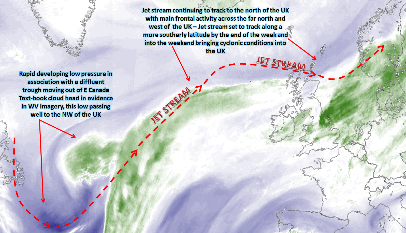
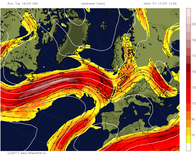
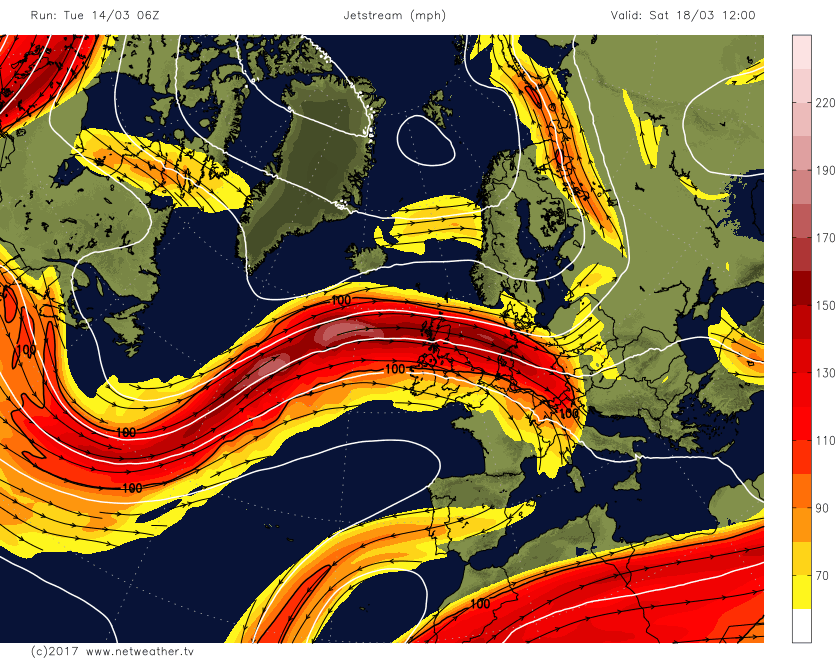
Fri 17th Mar: As we move into the end of the week and there is, again, good broad scale GM agreement for the jet stream to have more of a S’ly track across and into the UK rather than to the N of the UK than was the case earlier in the week. This development leads to a far greater risk of cyclonic conditions across the UK to end the week, the details of which are still somewhat uncertain. That aside for now and the overall pattern across and to the west of the UK becomes conducive for cyclogenesis and with more active frontal zones moving into the UK from the west as Friday progresses. The change in the track of the jet stream is highlighted well on the below image from the GFS, noting its more direct track across the UK.
The weather for Friday itself is likely to be a case of a reasonable start but with then a progression towards far more unsettled and cyclonic conditions as the day progresses. A number of potential baroclinic features will run into the UK from the west, as either individual defined frontal zones or potential frontal waves, the details of which are uncertain for now. However, what does seem to have good model agreement, and thus high confidence, is that the frontal zones moving into the UK will be well forced, this primarily due to the interaction of the jet stream allowing for marked upper-level divergence and hence ‘lift’ within the atmosphere. The GEM model does a reasonable job at highlighting this evolution with some significant regions of vorticity moving into the UK along with some particularly heavy precipitation too. The timing of this evolution is somewhat uncertain, but it would seem to be a case of the further S and E you are then the drier the weather will be for longest, but overall many areas of the UK will progress towards a wet and windy end to the working week.
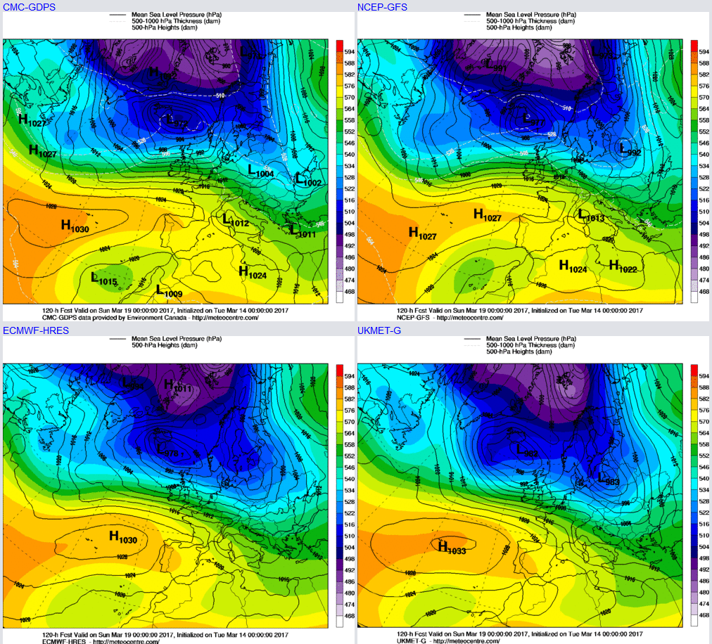
Sat 18th and Sun 19th: We move into the coming weekend, and the broader synoptic evolution continues to have high confidence given good model agreement between the 00Z ECM, GFS, GEM and UKMO and along with some reasonable model consistency too. The jet stream track will continue to be located over the UK, and this will maintain quite a mobile regime across the central and eastern N Atlantic. Further frontal systems are forecast to move into the UK, but there is considerable uncertainty over the details. Initially, though, let’s take a look at the expected position of the jet stream as Saturday progresses and this, overall, gives a good indication of the likely track of any further frontal systems into the UK.
At the moment Saturday may well start wet and windy across the UK and this being directly associated with Friday’s frontal system which likely continues to progress across the UK on Friday night and through into Saturday morning. There could well then be a brief ‘window’ of somewhat drier weather, but still with some showers, through the course of Saturday afternoon before further baroclinic features run into the UK from the west, either late Saturday or more particularly through Sunday. By the end of Saturday and overnight into Sunday and the main GM’s from the 00Z run are in good agreement for low pressure to be dominant just to the N of the UK and with higher pressure to the S, this synoptic setup also complimenting the position of the jet stream on the above image too.
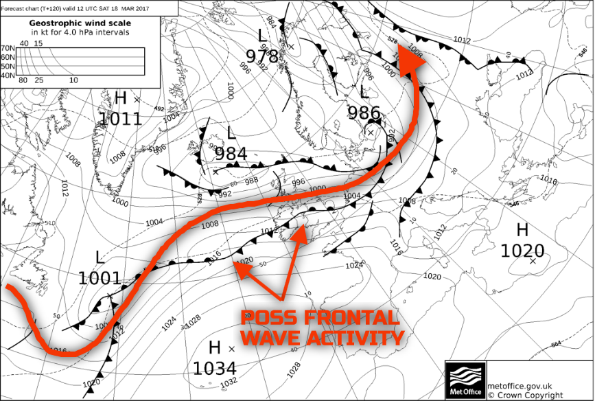
The exact details of the weather are uncertain for now, but a potential frontal wave may well rapidly develop within the broader W’ly flow later on Saturday and then overnight into Sunday. The UKMO FAX from the overnight period does show a frontal wave lying across the UK during Saturday. The position of this feature shouldn’t be taken at face value, but what it does highlight is a particularly baroclinic environment across the UK and with the jet stream directly over the UK, and to the W, then this, amongst other variables, could allow frontal wave development. This development would then lead to a greater risk of rain and showers running back into the UK from the W later on in the day. The approximate position of the jet stream, at 12Z Sat 18th, has been overlaid.
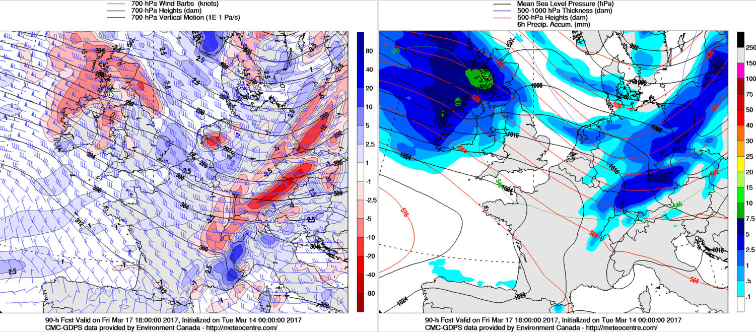
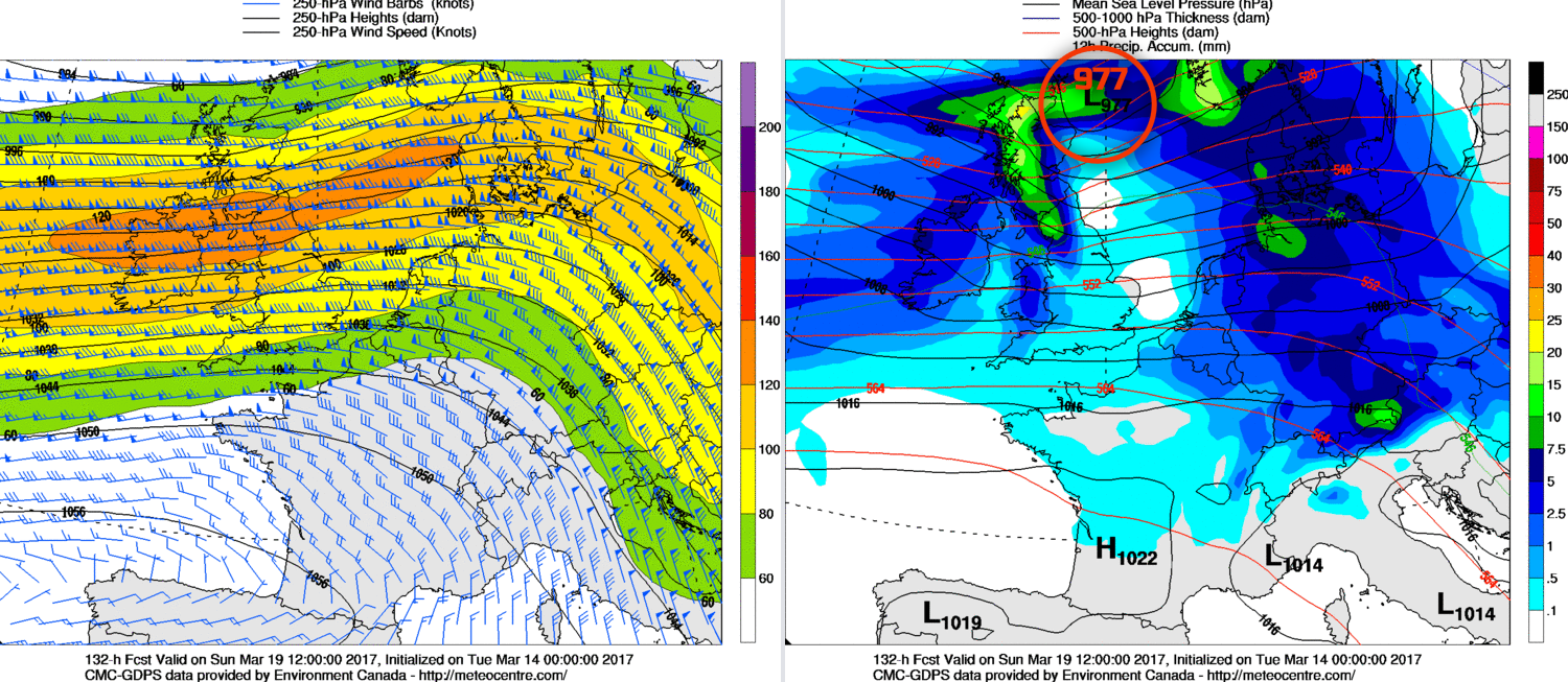
So, the general thinking at the moment is for overnight rain early on Saturday to clear to perhaps some drier weather, but with potential a region of residual rain or showers stretching into the UK from the West,. Thereafter, towards the end of Saturday and overnight into Sunday, a more pronounced cyclonic feature may well then track across the UK to bring a return to more widespread wet and windy conditions as we move through Sunday. The 00Z GEM model highlights just this, with a 977mb low passing just to the NE of Scotland at 1200Z on Sun 19th as the jet stream (120-140KT’s) passes directly over the UK. The weather just to the S of this low pressure would be wet and windy, as the model graphics highlight.
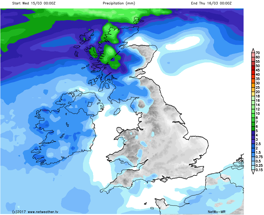
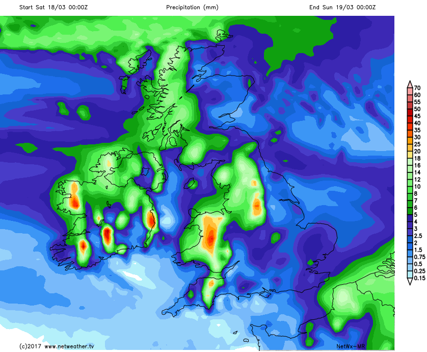
Also highlighting this overall progression towards far more cyclonic and unsettled conditions towards the end of the week and into the weekend is our rainfall accumulation graphics. Note the variation in the precipitation totals for day 2 (00Z Wed 15th to 00Z Thu 16th) to that of day 5 (00Z Sat 18th to 00Z Sun 19th).
Temperatures through the forecast period will, overall continue to be above average but particularly so in the short term with some further very pleasant conditions indeed through the rest of Wednesday and also potentially Thursday too across England and Wales. The Pm air mass behind the cold front on Thu though will signal a more general drop in temperatures to end the week and progress into the weekend, so certainly not as high, but even then temperatures won’t be below average. The progression towards wet and windy weather will make it ‘feel’ quite cold at times.
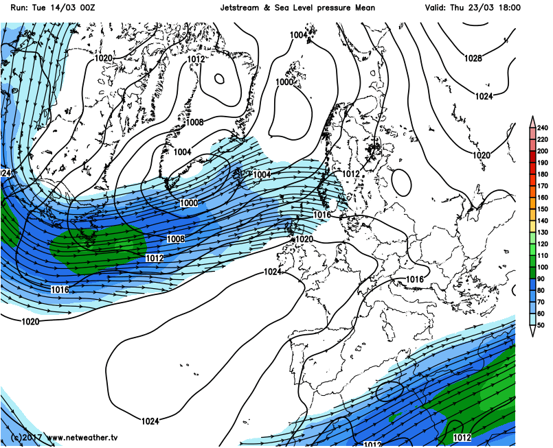
As we look further ahead towards the latter half of the month and, overall, the rather changeable patterns continue. Within the last day or so there has been a trend towards a potential rise in GPH with a greater risk of higher pressure becoming established across the UK though as next week progresses. This is in evidence on the below 00Z GFS ENS mean chart for MLSP and the jet stream with the Azores high extending NE towards the UK as the jet stream ends up tracking to the N again. However, the one thing that has been in evidence so far this March is the high variability and, at times, the unpredictability of the weather within the medium and longer term. A week or two back the approach to mid-March was signalled to become quite cold as a more meridional pattern potentially was set to develop across the N Atlantic. Clearly, that isn’t going to happen. So, as things stand the current thinking is, given other guidance too including the EC EPS, EC Monthly, is that a progression towards more in the way of anticyclonic conditions are likely through the second half of March, but with low confidence.