


Synoptic guidance - the coldest spell of the winter so far is on the way.
Issued at 1500GMT on Tuesday 10th Jan based on 10th Jan 00Z Model Runs
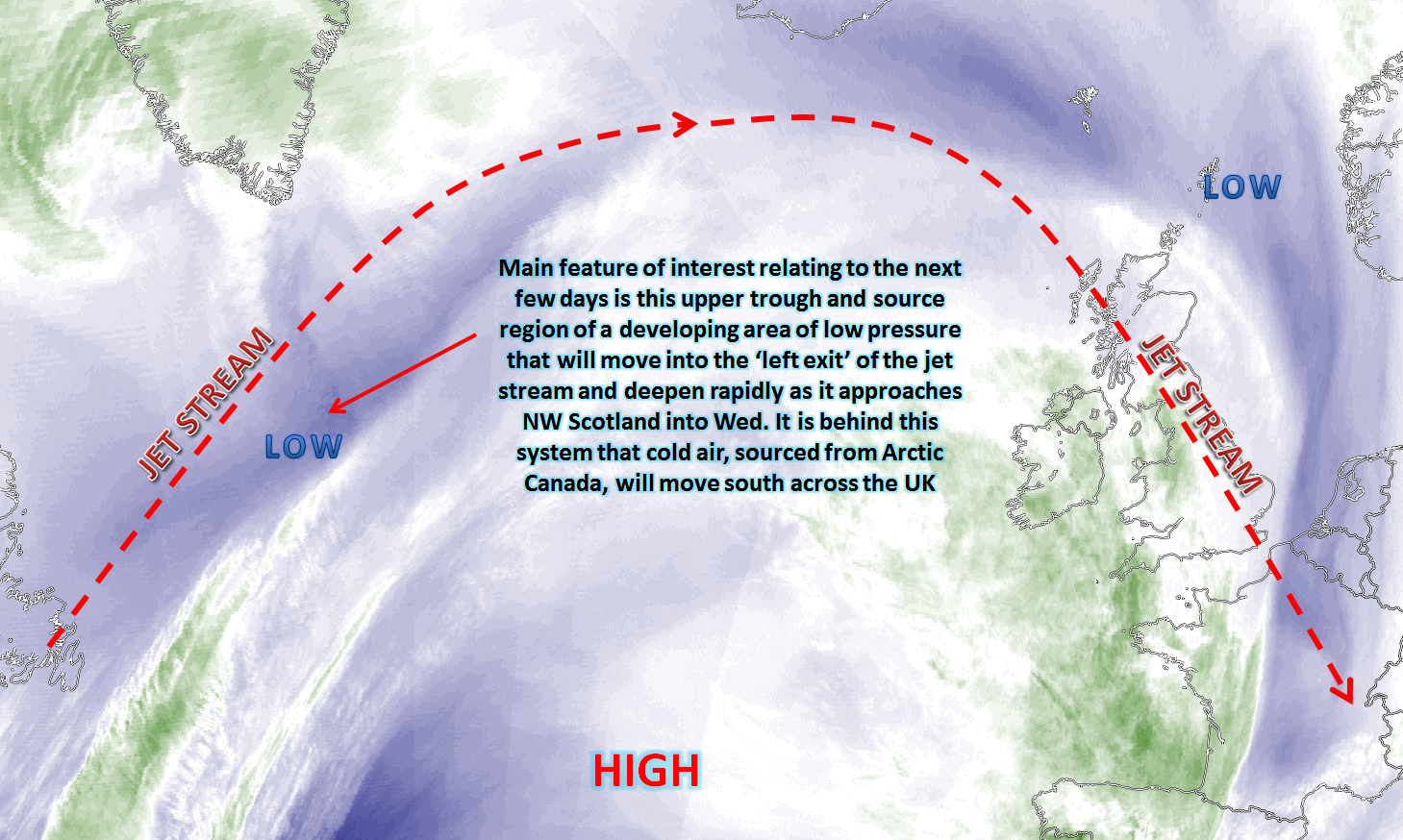
Wed 11th: As we move into Wednesday and model agreement is good with the GEM, GFS, EC, UKMO and JMA all showing a deep area of low pressure passing to the north of the UK during the course of the day. This is a complex development, and the phasing between the initial developing low on Tuesday and the left exit region of the jet stream does mean some uncertainties still over the final track and depth. That aside, confidence is high for a deep low pressure to be tracking to the north of the UK and it is this low pressure that will then introduce the colder air mass, sourced from Arctic Canada, from the north-west to all areas from the end of the day onwards.
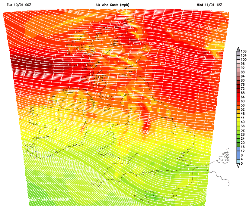
The other important aspect of the forecast for Wednesday is the strength of the winds. A very strong NW’ly wind will develop across all areas of the UK but with some significant gusts to the east of high ground due to capping/inversion influences. Gales or severe gale force gusts, so gusts in excess of 50mph to 60mph are possible across parts of Scotland and N England during the day in particular; this will bring some travel disruption, perhaps some structural damage, and will be one of the main features of the weather during the day.
The cold front associated with the low pressure will be a very weak feature with little forcing but it will clear to the south of the UK during Wednesday morning and it is then that CAA will take place from the north-west through the course of the day with 850mb temperatures, 1000-500mb thicknesses and WBPT values all indicating that snow will fall to all levels across Scotland by the afternoon and then to most of northern areas of the UK by the end of the day with increasing risk of accumulations by late Wednesday. Just highlighting the strength of the wind though is our SR HRES model.
Note the red shadings (50mph to 60mph) across parts of the Pennines for example where some very strong wind gusts are possible and more generally across the north of the UK. So before the wintry weather we have some very strong wind gusts to contend with through the day.
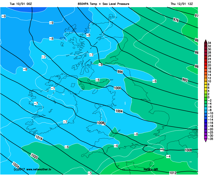
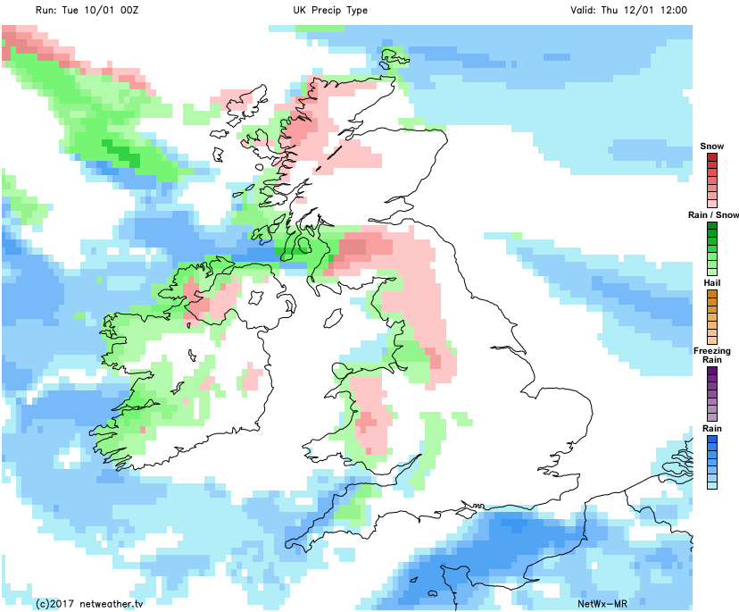
Thu 12th: We move into Thursday with a large scale upper trough in evidence over the UK and N Europe in general, whilst amplification to the pattern takes place across western areas of the N Atlantic. By Thursday morning all areas of the UK will be dominated by a cold air mass from the north-west, of which will be sufficiently cold enough for snow showers to fall down to most levels, especially across the north of the UK. The forecast models indicate the main areas at risk of seeing the snow showers will be across parts of Scotland, Ireland, NW England and Wales, those areas most exposed to a NW’ly flow. However, there is some uncertainty over the potential development of a frontal wave that may well move across southern England. There has been a distinct lack of consistency in the modelling of this feature, but there is scope for a more persistent region of rain to develop across far southern counties of England as Thursday progresses. Some heavy rain may well be a feature of the weather across coastal areas of S England, but on the northern flank then sleet and snow may well develop as the cold air mass from the NW undercuts the developing low. Our MR HRES model highlights that cold air mass well with 850mb temperatures generally sub -5C across the UK by 12Z on Thursday and locally down to -7C across more northern and western areas of the UK.
Deep instability will accompany the NW’ly flow and the showers may well merge to give some longer spells of snow for parts of the north and west. Forecast soundings show that CB development is possible and, as a result, there is a risk of thunder and lightning from some of the showers too, with the rather rare thundersnow possibly in evidence for some areas. Our MR model doesn’t really highlight the frontal wave precipitation across the south with it keeping most of the precipitation through the English Channel, but it is worth highlighting that longer spells of rain, with some sleet and snow, may develop across southern areas of England, but with clearly emphasis being on the snow showers further north and west which it does highlight. A general 2cm to 5cm of snow is possible even to lower levels across Scotland, Ireland, NW England and Wales, but with higher totals and with a continued strong wind then some drifting and blowing snow is possible on hills, perhaps with near blizzard conditions too.
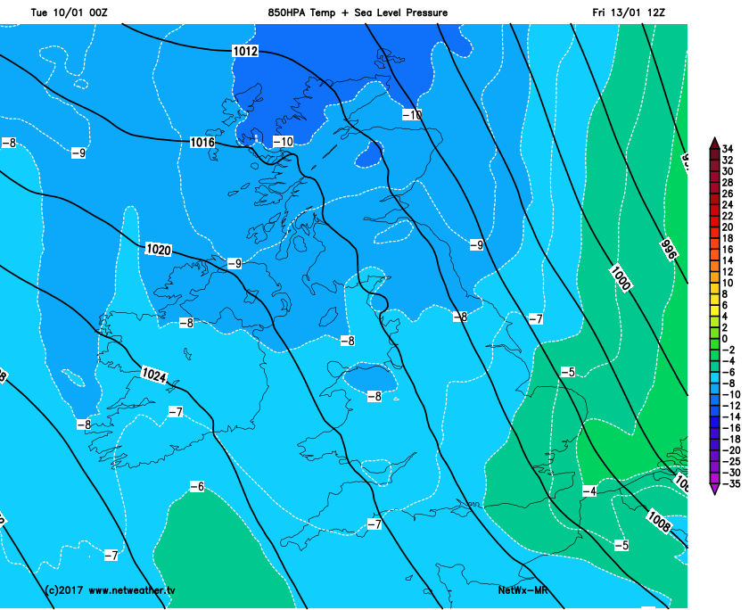
Fri 13th: The week ends with the cold air mass well in place across the UK as a cyclonic pattern continues too. Our MR model once again highlights well the expected ‘depth’ of cold air that will be in place across the UK by the time we get to Friday well with many areas sub -6C in terms of 850mb temperatures and locally down to -9C and -10C 850’s across the north of the UK.
The devil will most certainly be in the detail, however, because there is some model agreement for an area of low pressure to move down through the North Sea through the course of Thursday night and through into Friday. This may well signal a slight rise in thickness and 850mb temperatures for a time, but may also bring a more organised risk of showers, falling as rain, sleet and snow, down across the UK into Friday before clearing away to the south.
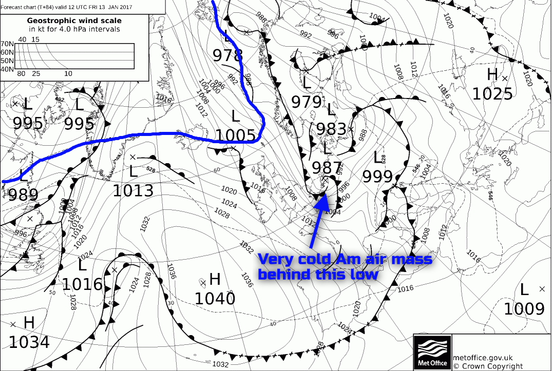
The UKMO FAX highlights the general consensus well as things stand with an area of low pressure around 987mb across the southern N Sea into early Friday and with then an Am air mass following on behind. As the flow veers more N’ly through the course of Friday then the distribution of the snow showers will change as well, with more eastern areas of England and Scotland then potentially seeing more in the way of snow showers through the day, whilst central areas of the UK generally have a cold, mainly dry and sunny day. The precipitation details though regarding the low pressure moving down the North Sea do remain uncertain, but some longer spells of sleet and snow may well move southwards early on Friday morning before quickly clearing.
Note to the 510dam thickness line (highlighted) on the UKMO FAX chart being just to the north, always an indicator of some very cold conditions from a UK’s point of view in winter.
Sat 14th and Sun 15th: As we progress into the coming weekend and the UKMO, GEM, ECM and GFS models then start to diverge, and the confidence regarding the details of the weather are particularly uncertain at this stage.
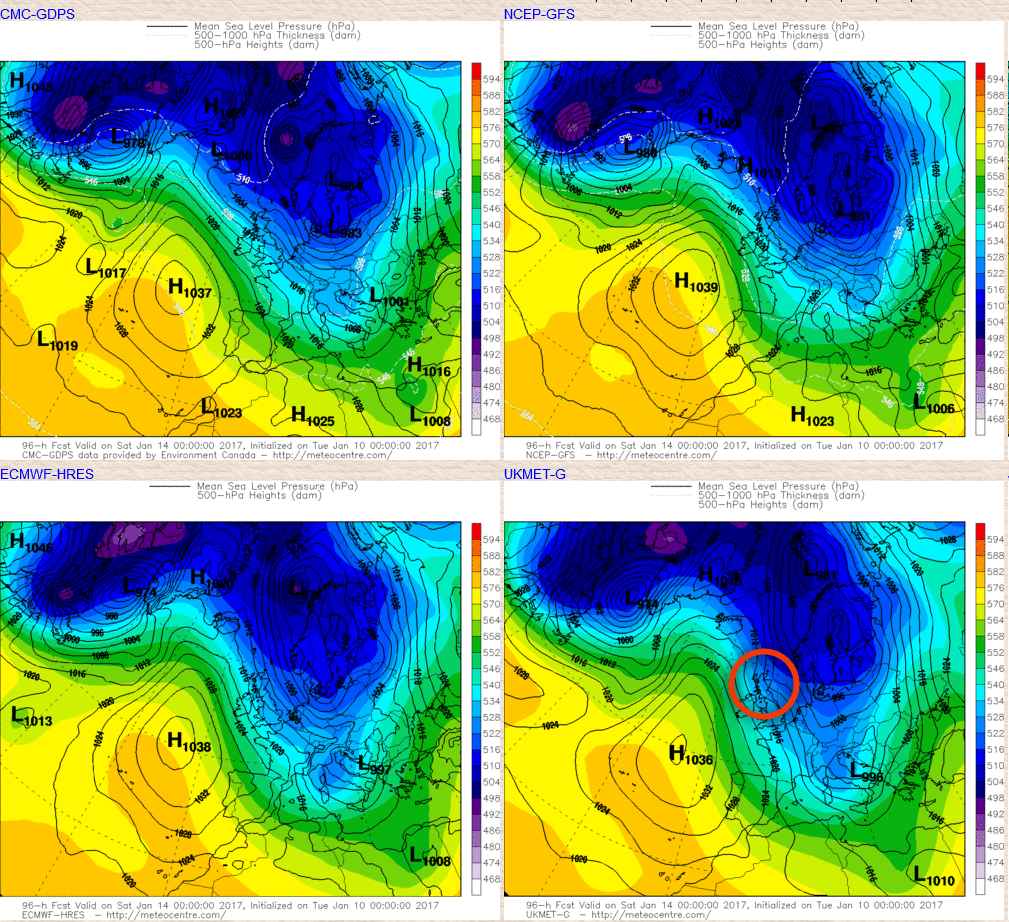
Overall there are some broader scale agreements regarding Saturday though and that is still for a large scale upper trough to be dominating just to the E of the UK, over N Europe, whilst there is some amplification to the pattern to the west and north-west of the UK. As a result confidence is medium to high to suggest that the colder N or NW’ly flow will still be in evidence on Saturday, this is particularly supported by the EC ENS for example.
The UKMO model though, in particular, has wanted to develop a low just to the east of Iceland and run that down into the UK from the NW to bring a wintry mix of rain, sleet and snow during the day, along with a recovery in 850mb temps. That development remains in doubt and for now a colder more convective, showery regime is the preferred option for Saturday at least. The GEM, GFS, ECM and the UKMO into Sat highlight the broader patterns well, but just note (highlighted) on the UKMO chart the small kink in the isobars indicating the low from the northwest. If that does arrive then it would bring a change in the detail to Saturday’s weather with a likely less cold day with a wintry mix of rain, sleet and snow, but for now further snow showers are likely around the periphery of the UK on Saturday, whilst across more in-land areas it is generally dry, sunny but cold with frost and ice early and late.
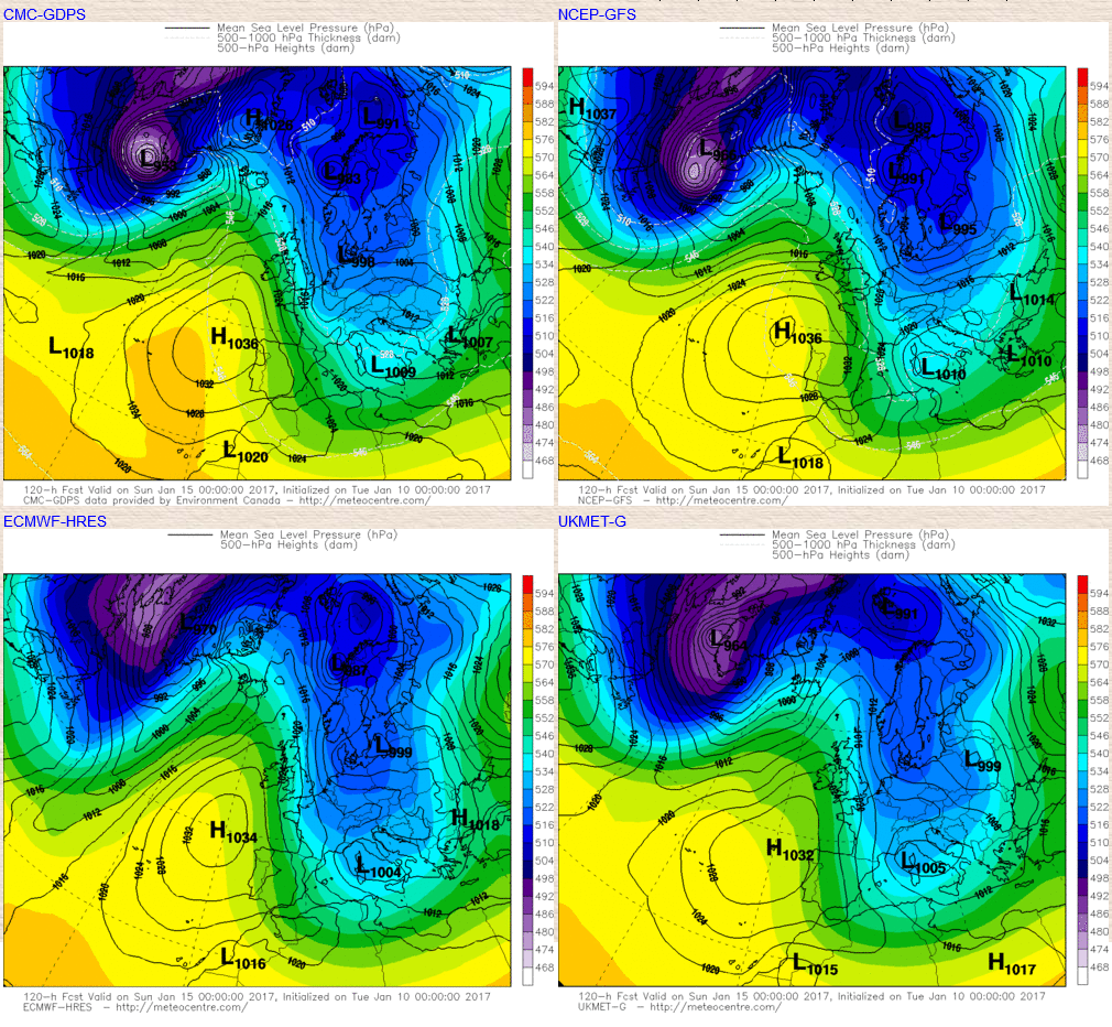
As we progress into Sunday and confidence levels, really do then fall away with quite a marked divergence between the models. The GFS in particular has been keen to break down any ridging to the west and flatten the pattern which then allows a milder air mass to arrive from the west during the day, perhaps with some sleet and snow on the leading edge of a frontal system. However, the likes of the GEM, but especially the ECM and the UKM maintain more of meridional flow over the UK as ridging remains more pronounced to the west and north-west of the UK.
The evolution is highlighted well on the 00Z models below, noting that ECM and the UKMO have more of a N’ly flow still into the UK during the day. The details are very uncertain, but with perhaps a few wintry showers still around coastal areas of the UK, but for W Scotland and Ireland potentially becoming milder with rain proceeded by some sleet and snow. The details of Sunday’s weather, given the uncertainties and variation within the models, are unlikely to be known for another day or two at least really.
The medium and longer term is particularly interesting at the moment with certainly the potential development of a cold E’ly air mass becoming more likely. The ECM model has been quite consistent over the last few days for building high pressure to the north-east of the UK to then allow for a cold continental flow to develop with 850mb temperatures dropping back down into the range of -5C to -10C across most areas. As usual, though a Continental air mass if often the coldest to affect the UK during the winter and given that central Europe has recently experienced some very cold air then the Continent is particularly ‘chilled’ at the moment so any air flow from there would certainly lead to some particularly cold weather for the UK.
The 00Z GFS and its ENS, along with previous runs have been at odds with the ECM though and hasn’t been interested in this development. At time of production of the Synoptic Guidance through the 06Z GFS run has changed towards the colder E’ly solution and given some good agreement within the EC ENS too, especially within the EC Clusters, then there is increasing confidence now to suggest that as next week progresses a cold E’ly regime could well develop across the UK leading to below average temperatures, widespread harsh frosts and perhaps, in time, some further snow. Further model runs are required to increase confidence levels, but as things stand it is the most likely evolution.


