


Mild and cloudy for now, with patchy rain spreading east. Windy on Wednesday with gales in the north, before cold arctic air sweeps south Thursday and Friday, with risk of snow in places - especially the north.
High pressure has been a dominant feature of our weather this winter so far, but this week low pressure is taking centre stage. Low pressure will be to the north of the UK today, bringing a fairly mild, cloudy and damp westerly flow. But as low pressure shifts towards Scandinavia from mid-week, a cold front sweeps south and winds will shift to a northwesterly direction, introducing progressively colder arctic air from Greenland by the end of the week, bringing an increasing risk of sleet and snow, especially in the north, but also a risk elsewhere.
For now, apart from a few showers across the far southeast of England – which should quickly clear, eastern areas of England and Scotland are starting on a generally dry and bright but chilly note, with temperatures ranging between 1-5C. Cloudier skies, milder and windier in the west, with isolated gales around western coasts, the westerly wind feeding in showers across western Scotland, NW England, Wales and SW England for the morning commute.
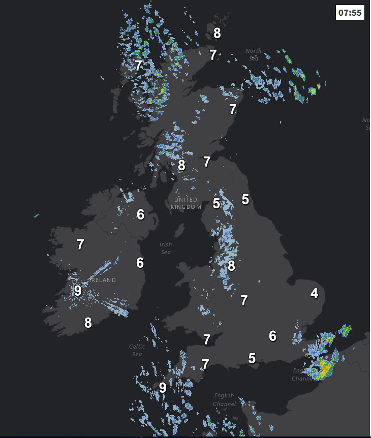
Through the day, the cloudier skies in the west will spread towards the east, taking away the morning sunshine and it will turn increasingly windy everywhere with westerly gales across the north and west. Patchy outbreaks of rain will spread eastwards too, though the far southeast of England and East Anglia may stay dry during daylight hours. Temperatures this afternoon reaching 7-8C in the east, 9-10C in the west.
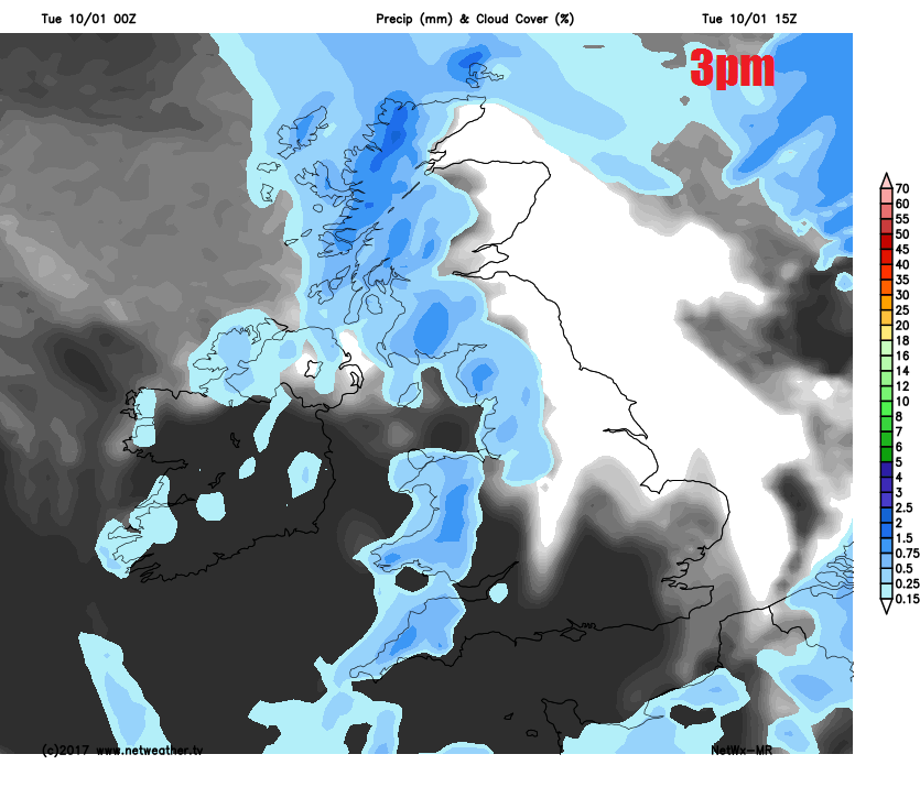
Mild, cloudy and windy tonight for many, patchy rain or drizzle generally clearing though perhaps lingering across southern and southeast England. Very windy across Scotland – with severe gales developing in the far north, heavy showers spreading in across western Scotland, showers peppering western coasts of NW England and Wales too.
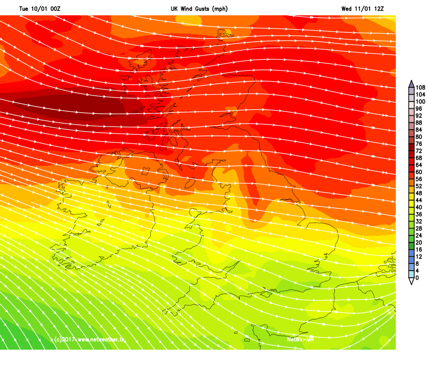
A strong westerly wind on Wednesday, with gales across the north, wind gusts of 50-60mph possible anywhere north of Wales and the Midlands. A generally cloudy day, with the wind blowing showers southeast across many parts, lighter towards the southeast, heavier towards the northwest. Turning progressively colder from the northwest too across northern areas, with showers turning to sleet and snow across Scotland by the evening. Afternoon temperatures reaching 7-9C across the south, but only 3-5C at best across the north as the colder air arrives.
Arctic air spreading down across all parts on Thursday on a strong northwesterly wind – which will feed in sleet and snow showers across northern and western areas, heaviest in the northwest, with a risk of 'thundersnow'. Wind gusts of 50-60mph in the snow showers may bring blizzard conditions over hills, reducing visibility. Snow will accumulate too, with 2-5cm possible, perhaps 10-20cm above 300m. We are also keeping our eye on a frontal wave forecast to run east across the south coast of England – which will bring a spell of heavy rain across southern counties of England and south Wales which has the potential to turn to snow on its northern flank as it bumps into the cold arctic air pouring down from the northwest. Though some uncertainty over this for now. Eastern areas of England and sheltered east coast of Scotland may stay dry, sunny and cold.
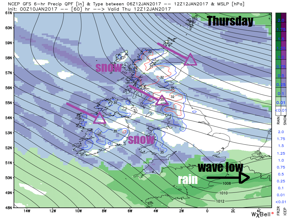
Temperatures reaching 2-5C across the north, 5-7C across the south. So feeling cold – especially in the wind, with a wind chill temperature of -2 to -4C across the north, 0C to 3C across the south. Frost forming inland overnight into Friday where skies clear.
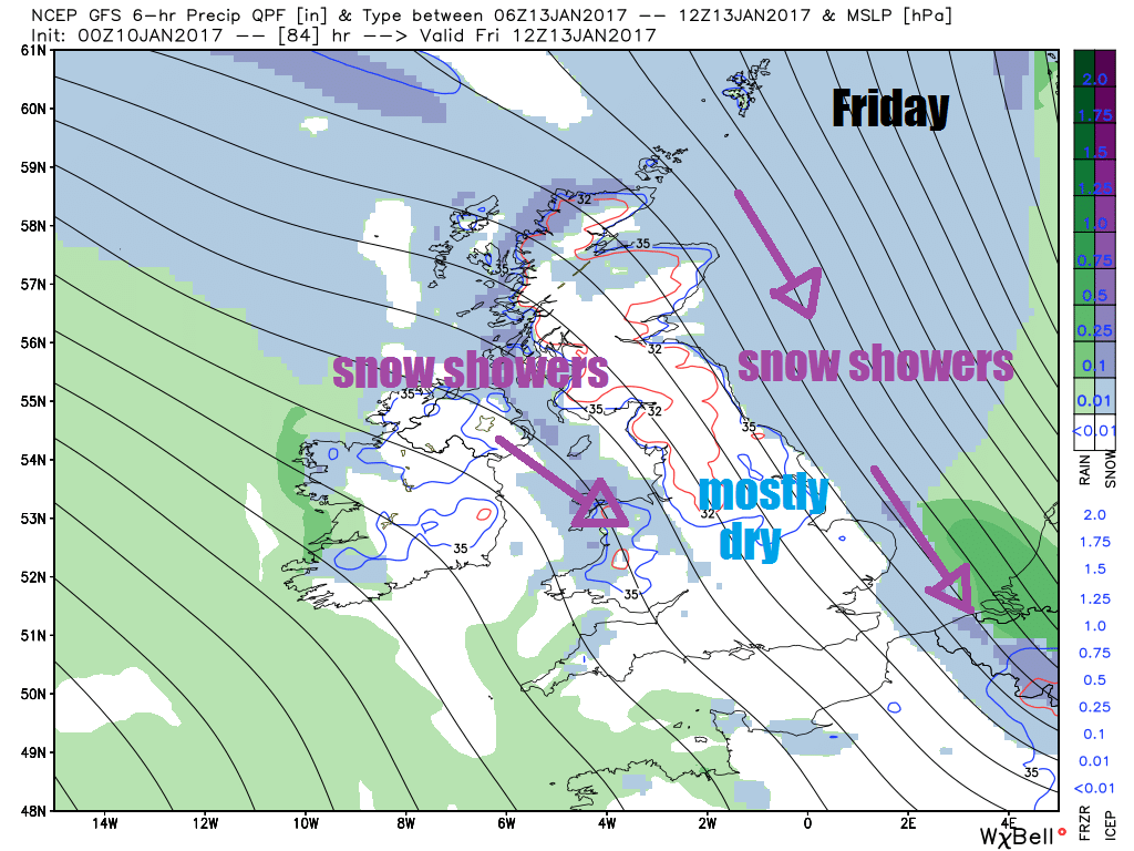
A strong north to northwesterly wind continuing on Friday, feeding further sleet and snow showers in across coastal areas exposed to the wind, perhaps a more organised area of sleet and snow moving south across the North Sea and clipping the east coast. Otherwise, many inland areas dry, sunny and cold with just a small risk of sleet and snow shower. A cold day, temperatures reaching 0-2C in the north, 2-5C in the south.
For the weekend, the cold northerly flow looks to continue on Saturday, with sunny spells and further sleet and snow showers in places, particularly towards coasts. We may see a more organised area of rain preceded by sleet and snow spreading southeast across western and perhaps central parts on Sunday, though some uncertainty over this, sunny spells and wintry showers in the east. Hints from the weather models that we may see and easterly flow develop next week, continuing the cold conditions, though low confidence on this outcome for now.


