Temperatures, gusts, rainfall, sunshine and snow. 2016 reviewed as the world warms up.
Review of 2016
Temperatures
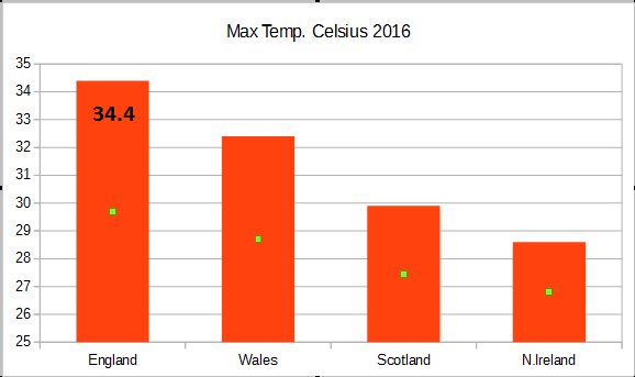
The top temperature occurred in September with Gravesend in Kent seeing 34.4C on the 13th (93.9F). An unusually late date for the annual maximum. This was part of the brief heatwave, which affected SE Britain, bringing much higher than average temperatures and sultry, humid nights. The warm and humid continental air also brought thunderstorms which resulted in flash flooding mid-month. Top 2016 temperatures for Wales 32.4C, Scotland 29.9C and Northern Ireland 28.6C (all on 19th July)
The UK record is 38.5C back in the summer of 2003, again in Kent at Faversham (101.3F)
This winter hasn’t been especially cold so far, and the lowest 2016 temperature was back in on Valentines Day with only -14.1C at Braemar. And so far, this winter we’ve had -12.1C in November.
The lowest ever UK temp. was -27.1C, again at for the same spot in Aberdeenshire in Jan 1982 and in the Highlands in 1995
Rainfall
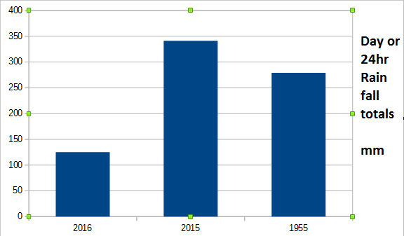
The highest 24-hour rainfall for 2016 was also back in February for Seathwaite in Cumbria on the 16th. 125.2mm of rain fell. This seems pitiful next to the highest 24-hour total, for any 24-hour period, which is 341.4 mm from 1800 GMT on 4th to 1800 GMT on 5th December 2015 at Honister Pass (Cumbria). This was thanks to Storm Desmond. The 1 day record is 279mm for Dorset back in 1955.
Winds
The highest 2016 gust was at the Needles lighthouse on the Isle of Wight. A very exposed, almost sea site. On 28th March, there was a gust of 106mph. The record for Needles was 115mph in 1998.
Angus - The first named storm of this winter hit SW Britain on the 19th November, with heavy rain. Southern England was very windy with the strongest gusts for Kent 81 mph at Langdon Bay, Kent (70Kt) and 84 mph at Guernsey Airport, Channel Islands (73Kt). Angus was quickly followed by another low pressure on the 20th which brought even more heavy rain and resulting in flooding for Wales and southern England. Parts of the West Country saw over a month’s worth of rainfall from this episode. There was travel disruption for rail and road traffic, flooding and heavy snow for northern England and parts of Wales.
Next the Christmas cluster of storms
Barbara arrived 23rd Dec into Christmas Eve with strong winds and heavy rain for northern and western UK, mainly for Western Isles
Conor hit the far north of the UK tail end of Christmas Day into Boxing Day with stormy weather for the Northern Isles
Snow
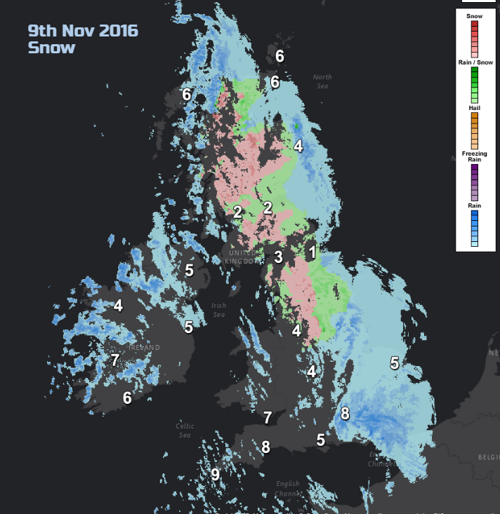
The morning of Weds 9th November was a snow day for some, Yorkshire, Derbyshire and parts of Scotland. Bingley in W.Yorkshire recorded 7cms of snow. There hasn’t been much so far, this winter. It’s been too mild or when cold, too dry.
We didn’t manage a white Christmas but parts of northern Scotland did have a white Boxing day with 3cm of snow falling at Aviemore and Cromdale in Moray. The highest recorded 2016 snow depth was 19cm for Leadhills in Lanarkshire back on the 10th January.
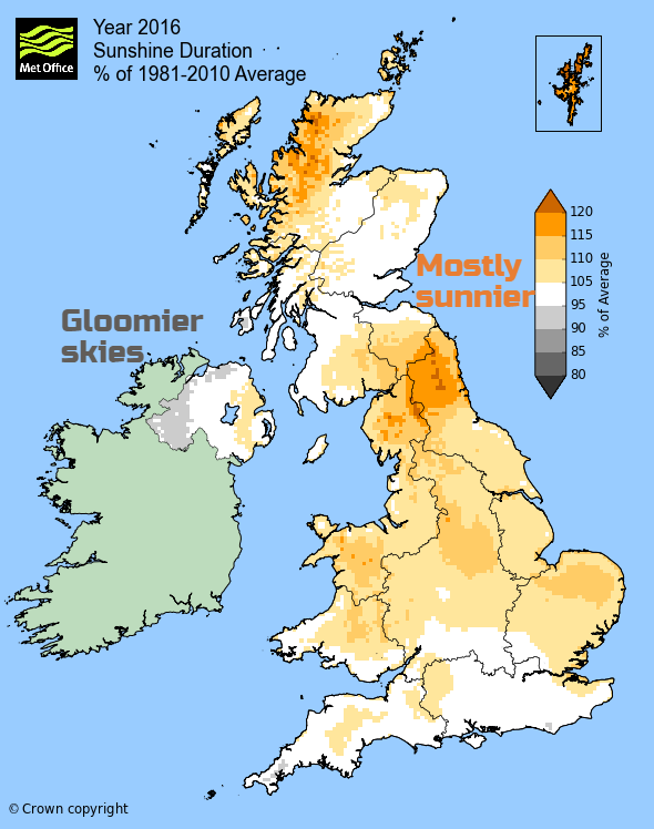
Sunshine
Lerwick won the sunniest day for 2016 with Shetland recording 16.7 hours on 5th June, and it wasn’t even on the longest day. Northern Scotland did very well for sunshine in October and November

Looking at climate
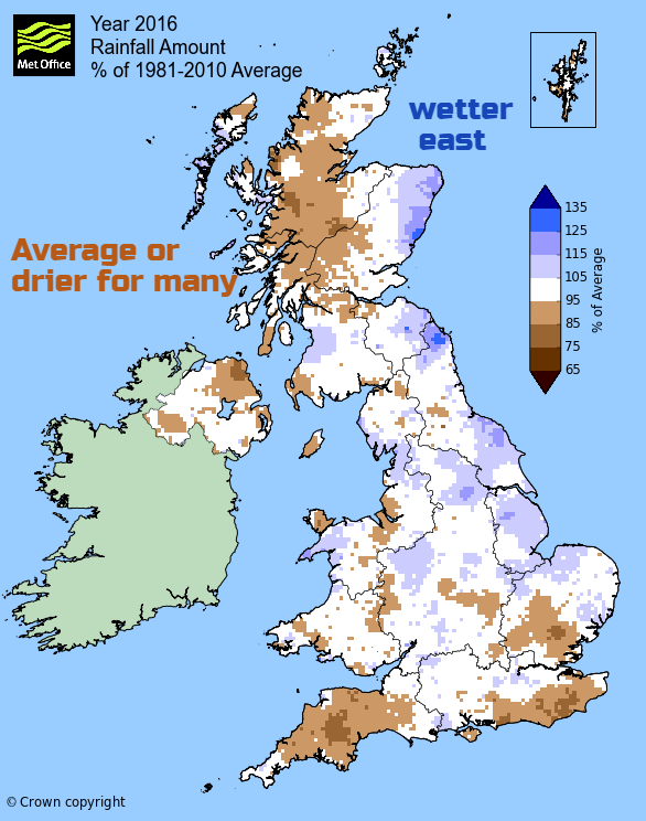
The Met Office have issued their 2016 annual data sets for rainfall, mean temperatures and sunshine which allow a comparison against the 1981-2010 average conditions. Nothing too startling with sunshine and rainfall data. Yes, December has been much drier than average.
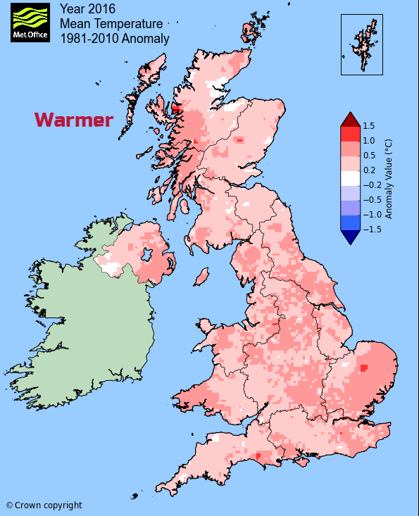
Temperatures
November was cold, December was mild. Overall, 2016 was warmer than average. A worldwide trend.
The provisional UK mean temperature for 2016 was 9.3 °C, which is 0.5 °C above the 1981-2010 long-term average and just outside the top ten warmest years in the historical UK series since 1910. It was also just 0.1 °C warmer than 2015.
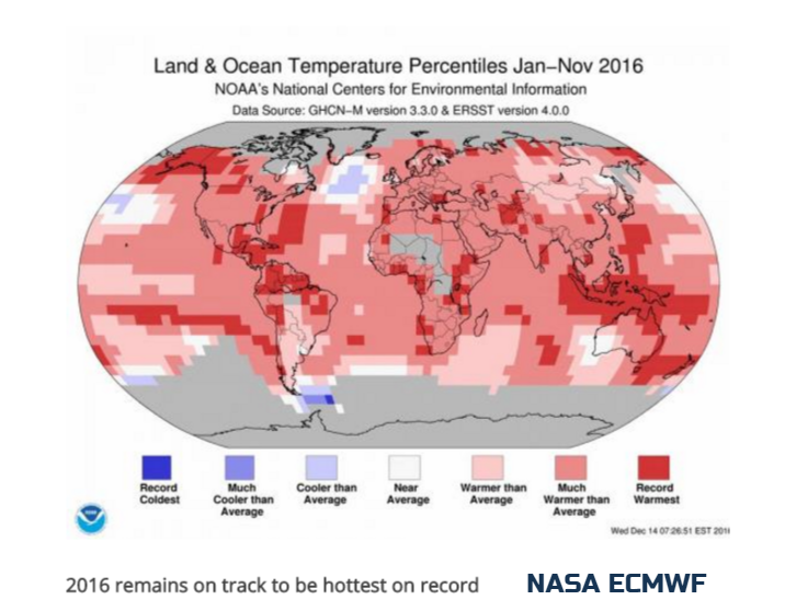
2016 remains on track to be hottest on record
The year 2016 remains on track to be the hottest year on record, with average global temperatures set to break even the records of 2015. WMO will issue final details about the 2016 state of the climate in the next week or so which will include December's data. 2016 saw a very strong El Niño event causing temperatures to leap at the start of 2016 and for many parts of the globe they have remained above the long term average.
WMO will take the pre-industrial era (early 1800s) as a baseline, and use three datasets from NOAA, NASA and the UK Met Office Hadley Centre and Climatic Research Unit, UEA. WMO also draws on re-analysis data from the ECMWF Forecasts, looking at all the observational data around the world.
Long-term indicators of human-caused climate change, including record carbon dioxide concentrations, and glacier melt, and low sea ice, continued. Arctic sea ice was exceptionally low, the Antarctic ice extent also lowest on record in November with both these areas impacting on the world's weather patterns.
WMO Secretary-General Petteri Taalas said .
The climate has broken records in 2016. In the oceans, record warmth contributed to widespread coral reef bleaching. And on land, droughts, floods and tropical cyclones disrupted the lives of millions of people as well as progress towards socio-economic development. A part of the disasters may be linked to climate change.
The strongest evidence for a human influence was found for temperature-related events --- the increased intensity of heat waves around the world, record-low Arctic sea ice extent in March and the extraordinary extent and duration of Alaska wildfires.
United States
Every single state and every single city in the Lower 48 states was warmer-than-normal in 2016. For the USA, the year ranked second warmest in records which date back to 1895. The U.S. has now had 20 straight warmer-than-normal years, and is warming at the rate of 0.15 degrees per decade.
The extent of the 2016 warmth is unparalleled in the nation’s climate history. No other year had as many states breaking or close to breaking their warmest annual average temperature. NOAA
Alaska posted its warmest year on record for the third time in as many years. Its temperature was nearly 6 degrees above average is rising at the feverish pace 0.3 degrees per decade. Set alongside the warming trend in the Arctic, the Arctic is warming at about twice the rate as the global average.
Set against the backdrop of record- and near-record warmth, the nation witnessed extreme rainstorm after extreme rainstorm.
Words of warning from Mr Taalas.WMO
Scientific studies are increasingly proving the link between extreme weather – especially heat – and human-induced climate change from greenhouse gases. This increases the need for investment in better impact-based weather forecasts and early warning systems to save lives and support climate change adaptation both now and in the coming decades ahead.
More in the Netweather community forum - Climate Change