


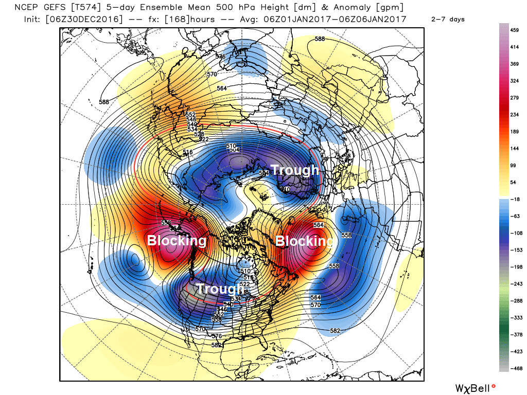
Recent NWP model high resolution runs and ensembles indicating increasingly 'blocked' pattern with temperatures falling below average towards mid-January.
It is looking increasingly likely that early January will, in the means, see temperatures below average, only slightly to begin with, but perhaps more so toward mid-month looking at the extended GEFS and EPS 500mb heights and temperature anomalies.
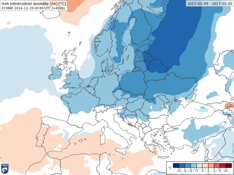
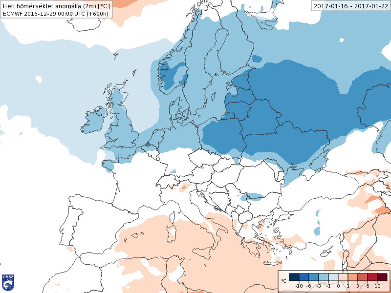
Temperatures towards and beyond mid-month falling below average UK and N Europe as per on yesterday's ECMWF weeklies (week 2 and 3) temperature anomalies
The upper flow pattern over the northern hemisphere is undergoing a number of changes over the coming days, that recent/current model output suggests will aid in bringing below normal temperatures to much of northern Europe and also the United States of America.
The upcoming pattern advertised is fairly typical of La Nina. Indeed, the most recent NOAA Climate Prediction Centre ENSO analysis (26th Dec) indicated La Nina conditions are present, with negative sea surface temperature (SST) anomalies present across most of the central and eastern equatorial Pacific.
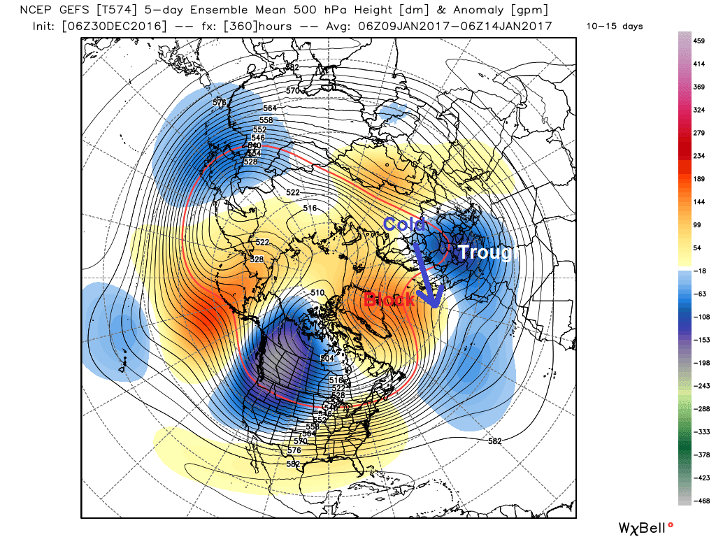
The La Nina base state combined with atmospheric wave breaking off the eastern Asian continent and wave propagation from anomalous tropical convection over the Pacific, as depicted by a Madden Julian Oscillation (MJO) wave progressing eastwards is likely behind developing a strong ridge northwards in the dateline area over Alaska and far west of Canada. This in turn amplifies the flow downstream over N America (deep trough) and the north Atlantic (ridge) and Europe (deep trough). Such a wavy configuration creates cold arctic air to surge south into the troughs (N America and Europe).
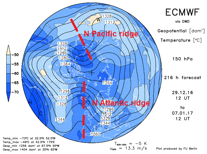
The anticyclonic wave propagation over the north Pacific and north Atlantic/Greenland is also reaching the lower stratosphere as per 150 hPa geopotential height and temperatures (below) with signs of wave breaking also reaching the upper stratosphere. This tends to further support the blocking highs' duration too.
Initially in the short range we see a lobe of the tropospheric polar vortex over NE N America, which brought a winter storm across northern New England on Thursday, while ahead of this PV lobe a ridge amplifies north over the N Atlantic into southern Greenland and downstream of the ridge we see northerly develop a cold snap across the UK New Year’s day. The upper flow then de-amplifies over the N Atlantic for a few days next week after the 1-2 day arctic northerly flow Sunday-Monday, squashing down the ridge to the west of the UK, with less cold westerly flow taking over.
However, upstream, the models and their ensembles are in fairly good agreement of building a strong north Pacific ridge north across Alaska which will encourage an amplifying western U.S trough, with deep cold returning back south across western and central U.S, before upper troughing extends east across much of N America eventually in the medium range. This in turn re-amplifies a ridge over the N Atlantic north into the Greenland and Iceland area. This leads to a second northerly developing later next week as advertised by recent and current operational runs of GFS and ECMWF.
1st Northerly New Year's Day through into early next week
2nd northerly develops next Friday and into next weekend
So we have agreement on 2 northerlies. One kicking in on New Year’s Day and continuing into Monday – bringing wintry showers to the north and along eastern coasts – with temperatures reaching 5-6C at best on Sunday, 3-6C on Monday. A little less cold for a few days as winds ease and turn northwesterly or westerly, though temperatures generally staying in single figures. Before another northerly reloads towards the end of the week, probably Friday or into Saturday, this time the low moving SE and triggering the northerly flow looks deeper on recent runs and thus likely dragging in a colder arctic flow and wintry showers across northern and eastern areas.
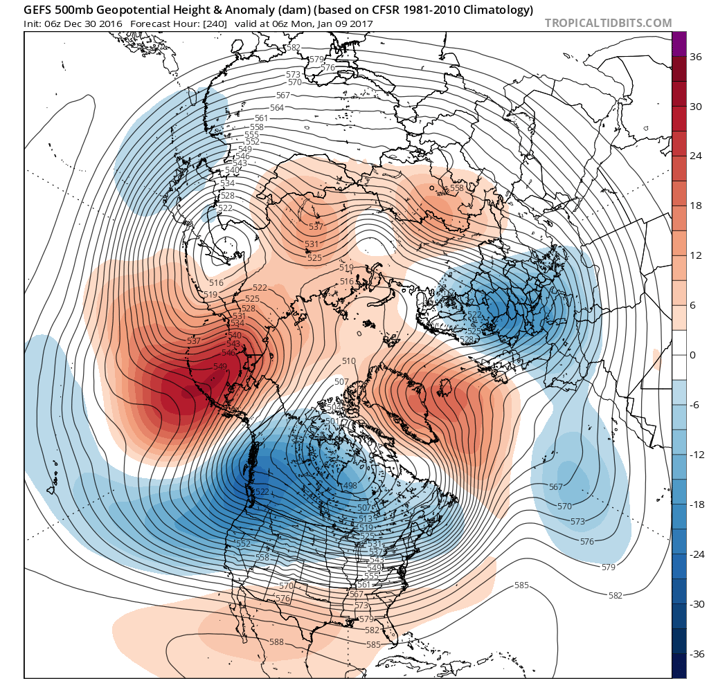
After the 2nd northerly develops in a week’s time confidence drops, as it would generally, given the time range. However, today’s 00z ECWMF deterministic run to day10 and EPS (ECMWF ensembles) 500 hPa mean and anomalies days 11-15, along with the 06z GFS operational and ensembles 500 hPa mean/anomalies in the day 11-15 range support the idea of positive geopotential heights / blocking re-building to the NW/N over Greenland/Iceland/Scandinavia area later next week extending east toward Scandinavia too. While further south the block is undercut by troughing extending east from N America across the north Atlantic which eventually joins lowering heights / -ve anomalies over mainland Europe, as deep cold polar continental air drains south and southwest from NW Russia and NE Europe. Such a pattern favours a flow from the NE or E across the UK from next weekend towards mid-month, tapping into some very cold air over Scandinavia and eastern Europe.
GEFS 500 hPa mean/anomalies days 10-15 show a cold pattern for UK and N Europe, with blocking to the N and NE and troughing to the south = N/NE/E flow.
With this blocking high signal from the ensemble guidance to the north in the Iceland area or NE over Scandinavia lasting to at least mid-month – this could be a cold pattern for the UK and northern Europe that locks in for a protracted period too. Though it must be stressed confidence in this outcome, for now, is not high.


