
#StormAngus, the first named storm of the season, will bring severe gales and heavy rain to southern Britain tonight and Sunday morning. Then followed by another deep low bringing heavy rain and gales for Monday.
The UK Met Office have officially named the first storm of the autumn #Storm Angus, a deepening low in the Atlantic this afternoon which will dive southeast into the SW approaches before swinging NE across southern England Sunday morning, before exiting East Anglia early afternoon.
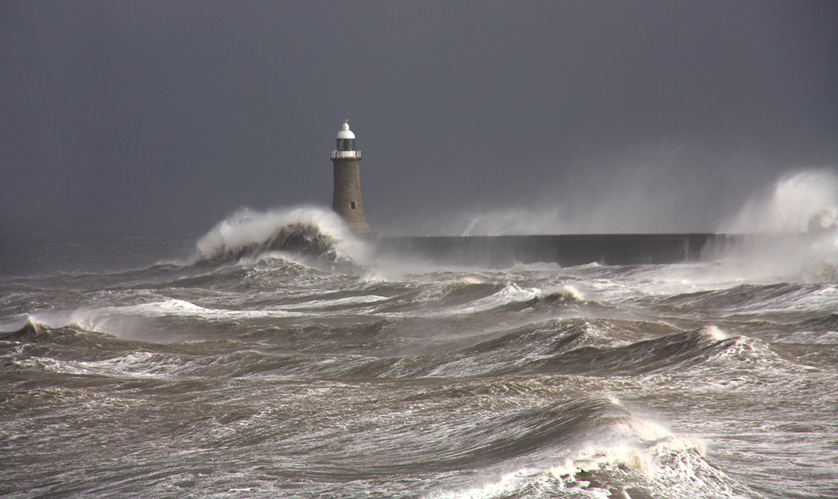
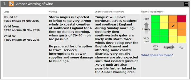
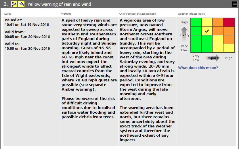
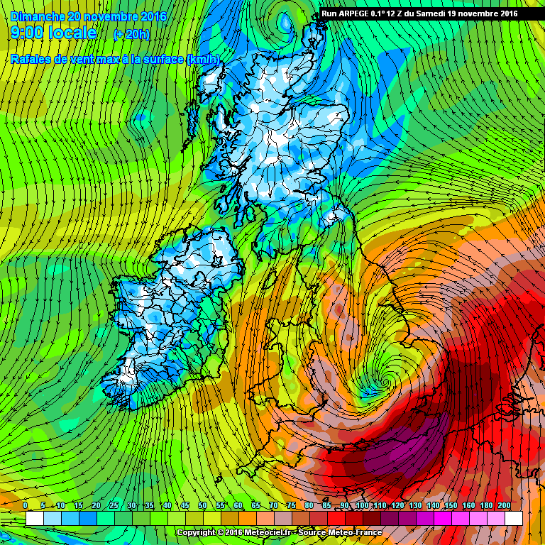
The vigorous depression will bring gales to parts of southern Britain from tonight into Sunday morning, the worst of the winds, up to 80mph, will be towards the far SE corner of England. The Met Office have issued and Amber Warnings for violent southwesterly winds affecting coastal areas from the Isle of Wight eastwards including coastal Sussex and Kent – where the Met Office indicate gusts of 70-80mph are possible. A yellow warning has been issued for strong winds and heavy rain for other southern counties further west, parts of the Home Counties, London, Essex and coastal Suffolk. Here the Met Office indicate gusts of 45-55mph inland likely, and 60-65mph near coasts.
Early Saturday evening, Angus is currently deepening over the Atlantic to the SW of Ireland. The low as of 1500hrs GMT was approx. 983mb and is expected to deepen further as it swings in making landfall across central southern England tonight. Angus deepens rapidly before it arrives across S England tonight because it phases favourably with the jet and a shortwave trough dropping SE from Greenland.
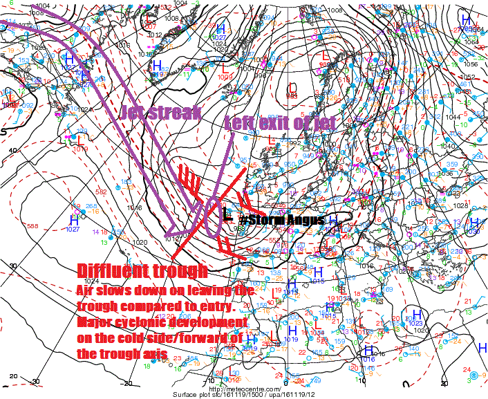
Angus moved onto the cold side of the a strong jet streak moving across the Atlantic today – which tends to aid in rapid cyclonic deepening. Also as Angus approaches southern England it will be under the developmental left-exit region of a 100mph+ jet streak rounding the base of a long-wave upper trough extending down from the polar regions to the north. The left exit of the jet is where winds diverge aloft – creating a vacuum which has to be filled by air converging at the surface and rising – creating lowering pressure. Also Angus phases favourably with a diffluent short-wave upper trough rounding the base of the broad longwave upper trough extending down from the north. Stronger winds entering the trough compared to exiting it tends to favour major cyclonic development on the forward side of the trough. Also, the cold upper trough is providing a steep temperature gradient fuelling the strong jet.
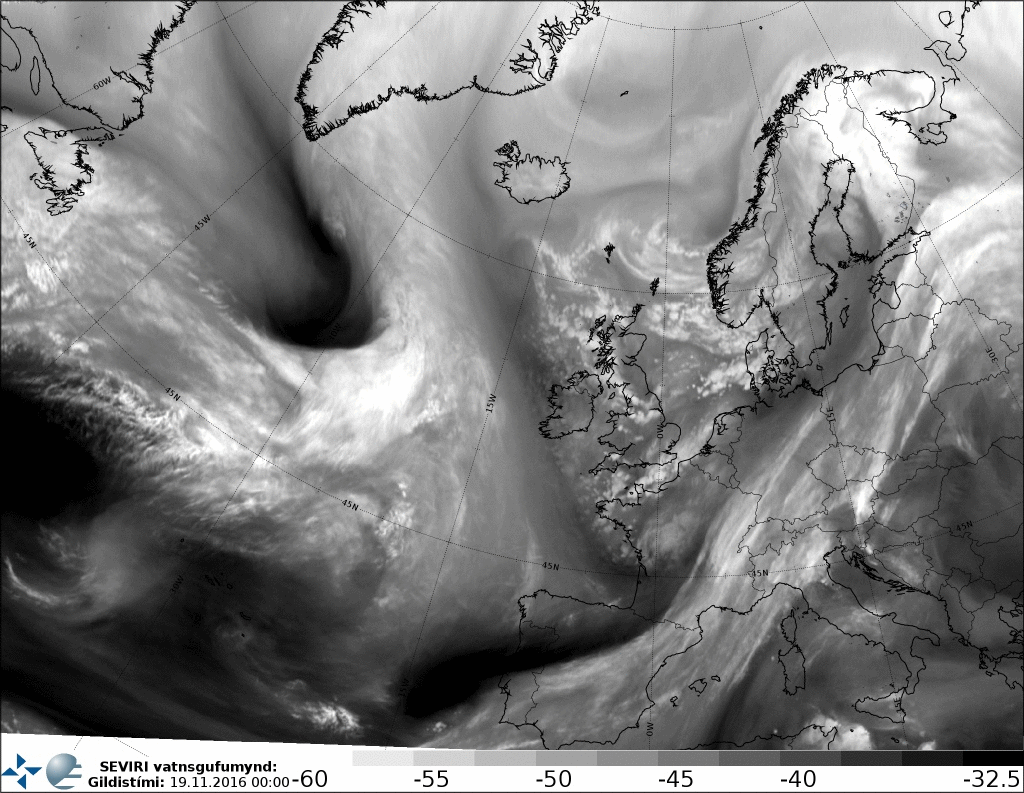
The dark stripe of the dry air intrusion, shown in the WV loop below, is dry air descending on the northern flank of the jet stream and this dry air, if it continues to descend, can cause strong winds aloft to fall to the surface as gusts, particularly in heavy showers or storms embedded in the low's circulation.
The 12Z GFS run makes landlfall with Angus around 12hrs later around 3am Sunday morning at around 974mb, when the low’s pressure will bottom out as it crosses SE England and E Anglia, before pressure slowly rising as it heads out over the North Sea. Peak gusts look around 6am across Kent/Sussex coasts with gusts of 60-70mph.
The 12z French Arpege model had Angus even deeper at 966mb 3am further west across Devon, some 17mb drop in 12hrs, which is rather significant RACY (rapid cyclogenesis). 12z Arpege model shows gusts of 110-120 km/h (68-74mph) toward Kent and Sussex coasts at 10am.
The 00z ECMWF out this morning bottomed out pressure at 967mb to the SW of Cornwall before the crossed SE England at 970mb around 6am Sunday.
The 12z UKMO-GM had the low at 970mb at 6am Sunday across SE Midlands/Nern Home Counties – so again deeper than GFS and some 6mb deeper than the 00z run of UKMO-GM.

So, given models have deepened the low more than others and more than earlier runs, with some showing wind gusts of in excess of 70mph towards the English Channel coasts, you can see why an amber alert has been issued.
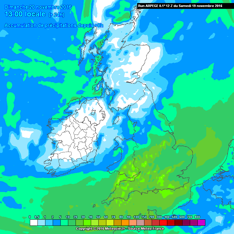
Heavy rain from Angus has also be warned of in the Met Office yellow alert across southern England. I would include south Wales, Midlands and E Anglia aswell as southern England. 12z GFS shows some spots seeing 20-30mm in 12hrs, Arpege 25-35mm. The rain is likely to turn to snow too over higher parts of Wales, The Midlands and northern England as it pushes into the cold air already in place from the last few days.
Then another deep low arrives on Monday.
Hot on the heels of Angus, another shortwave upper trough of cold air and jet max dropping SE from southern Greenland / Labrador will cause a wave to the SW of Ireland Sunday morning to deepen into a closed low which further deepen then drift toward NW France before swinging NE then north across England and Wales on Monday while continually deepening. This low will bring a swathe of heavy rain northward across England and Wales ahead of it on Monday, before GFS and UKMO-GM has the low arrive across SW UK then central England Monday night.
By early Tuesday, 12z GFS suggests some parts of England and Wales could have seen 50-70mm rain from Angus and Monday’s system – which may be named too (#Barbara?)

With Monday’s low, the strongest winds this time look to be on the north and western flank of the low as drifts NE across SW then central UK. 50-60mph N to NEly wind through Irish Sea, SE EIRE, Wales then northern England. Though gales likely to develop to the east of the low too across southern and eastern England.
Please stay tuned to local TV News and Radio and also updates on Twitter for the latest on Storm Angus. You can follow how Storm Angus progresses with live updates on our dedicated thread on the Netweather Forum here


