The polar vortex, which normally strengths this time of year, is weak and may remain so as we head into winter, which will increase likelihood of blocking and cold outbreaks for the UK/Europe in early winter.
After a run of mild and stormy winters since 2013, we may see a cold start to winter 2016/17 thanks to a weak Polar Vortex
Warm arctic could be the main cause of a weak Polar Vortex, but combined with other facors such as weak ENSO and decreased sun spot activity, despite westerly QBO which suggests a strong PV.
Already this autumn Atlantic mobility, i.e. storminess with wind and rain, has been brief and high pressure blocking often dominant.
It is more likely than not that high pressure blocking at mid or high latitudes of the northern hemisphere will re-occur as we head through late November and into December - with an increased chance of cold outbreaks.
The polar vortex may remain weak well into early winter which could lead to a cold start to winter for the UK.
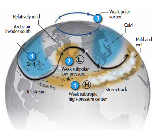
Diagram below, courtesy of Scientific American, shows cold air normally bottled up in the arctic by a strong Polar Vortex tends to flood south with a weak polar vortex
The UK has seen a succession of mild or very mild winters since winter 2012/13, but we could see this recent run of balmy winters may be coming to an end, thanks to a weaker than normal Polar Vortex so far this autumn, which may lead to a cold start to winter at least.
Recent years have seen extreme examples at either end of the spectrum of a strong and weak polar vortex. The last 3 winters have seen a strong polar vortex often bringing stormy weather across the North Atlantic and the UK. During winter 2013/14 and again in 2015/16 it was particularly strong and was blamed for record-breaking cold in eastern US while driving a very strong jet across the Atlantic that brought a very cyclonic winter in the UK with often very stormy weather that brought severe flooding and storm surges. The start of the decade though saw a weak or compromised Polar Vortex than brought the cold winters of 2009/10 and 2010/11.
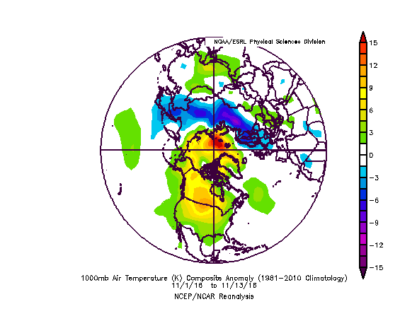
Last November was rather mild and wet throughout, as a mobile upper flow with a conveyor of Atlantic low pressure systems dominated the weather. However, this November, so far, has been rather different to last year in that Atlantic mobility, i.e. areas of low pressure passing over or to the north of the UK bringing wind and rain, has only lasted in short bursts before the flow has buckled and become more meridional to allow areas of high pressure to build across the UK. A look at the 1000mb and 500mb anomaly for 1-13 November highlights predominance of low pressure/low heights over central/southern Europe with higher pressure/heights anomaly over the N Atlantic and Scandinavia. So, the pattern has been quite blocky at times since the start of the month, with no real inertia from Atlantic mobility albeit brief interruptions from low pressure before mobility recedes again.
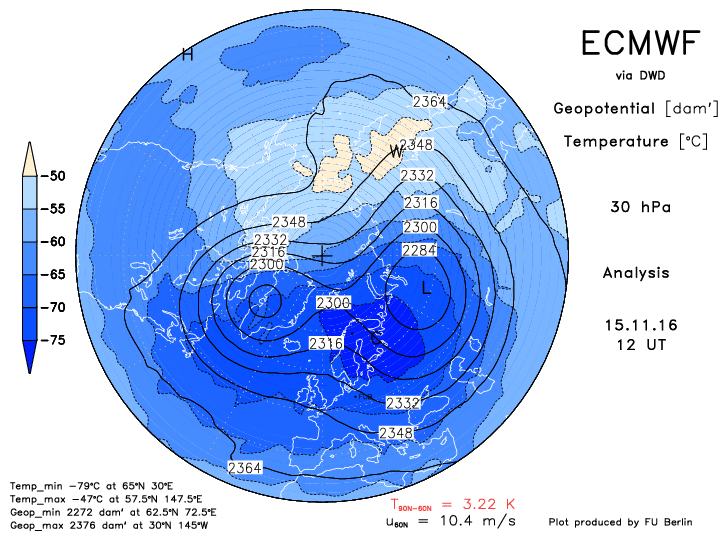
Normally in autumn the Polar Vortex begins to strengthen in the stratosphere over the polar region of the northern hemisphere as the days shorten and stratosphere cools. However, the stratospheric PV has been in a more weakened state than is the norm so far this autumn and has shown signs of splitting in late October and early November. Although the stratospheric PV circulation is several kilometres up in the atmosphere, its position and strength can influence the position of the jet stream which controls where areas of high pressure and low pressure form and persist. The position of cold vortices or upper lows in the troposphere, where our weather happens, can be influenced by the cold air stratospheric PV propagating downwards. So if the PV displaced southwards or splits, pools of deep cold air can shift south into Europe, Asia or N America with them.
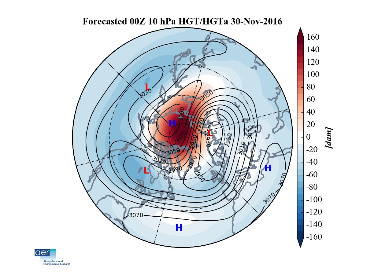
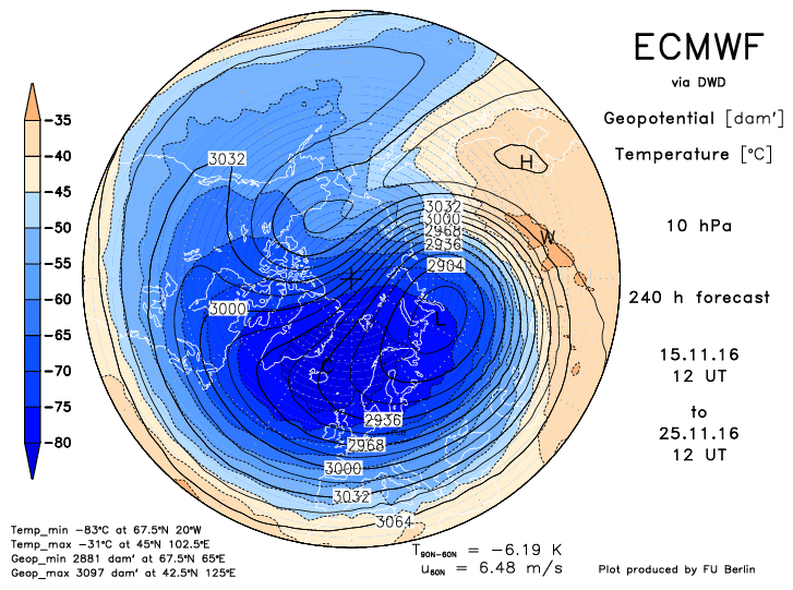
Images below, (left) courtesy of Judah Cohen at the Atmospheric and Environmental Research (AER), shows the Polar Vortex 'under attack' later this month on one GFS run yesterday, then the ECMWF (right) has similar evolution as far as the 25th.
So what is causing the polar vortex to be in a weakened state and the weather pattern blocky this autumn/early winter?
Long term drivers of a weak PV and blocked pattern
An important driver for the strength of the PV is the Quasi Biennial Oscillation (QBO), which are stratospheric winds above the equator which can directly influence stratospheric circulation at higher latitudes. The QBO is currently in a westerly phase, which normally favours a stronger PV. While an easterly QBO favours the opposite. However, the QBO phase appears to be having little impact yet. The QBO is normally a fairly reliable and predictable atmospheric pattern that lasts in westerly or easterly phases for around 28-29 months before changing. However, last February the QBO experienced and unprecedented flip from easterly back to westerly after only turning easterly the year before. The flip has been attributed the very strong El Nino last winter, but could also be caused by climate change.
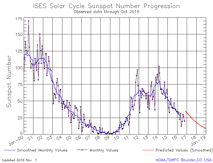
So, the QBO doesn’t look a player to weaken the PV. Another factor that maybe influencing the PV is the solar cycle of sun spot activity. Currently we are in a period of decreasing solar spot activity (high sun spot activity = solar maximum) since a peak in winter 2014/15. This year has seen sun spot activity at its lowest since 2010/11. Incidently, the cold winters of 2009/10 and 2010/11 were partly attributed to low sun spot activity / solar minimum. So this could be a factor in weakened North Atlantic jet this autumn.
Arctic Sea Ice extent has seen a rapid reduction in recent years and currently sea ice extent in the arctic is very low. This is is tandem with well above average temperatures across polar or arctic regions of the northern hemisphere, which is probably having a detrimental effect on the usual strengthening of the polar vortex or rapid cooling of the stratosphere over high latitudes. These warm temperatures in the arctic are reflected in higher than normal pressure/heights over the arctic - which leading to a predominantly negative Arctic Oscillation (AO) since early October. This circulation, if it persists in winter, favours warmer arctic and colder continents - particularly in Europe if it combines with a negative North Atlantic Oscillation (NAO)
Record low arctic sea ice extent in 2016

The arctic has been warmer than average so far this month, as has much of Canada, Europe colder than average
The ENSO (El Nino Southern Oscillation) can be a factor that can have an effect on the upper flow and the PV during a northern hemisphere winter. The U.S. NOAA forecasters indicated on the 10th November the arrival of La Nina, which is favoured to stick through winter 2016-17, following the weakening of the record strong El Nino earlier in the year that dominated last winter. The average response of the stratospheric polar vortex to past El Niño events is a weakening of the vortex in late winter or early Spring and an increased chance of polar vortex breakdowns (i.e. Sudden Stratospheric Warmings or SSWs). This is generally what we saw this past winter, except that during early winter from November to mid-January the vortex was strong bringing wet and windy weather and few cold air outbreaks. When the ENSO is in La Nina (cooler than average tropical Pacific waters) – it tends to favour wetter and cooler conditions across the northern tier of U.S.A while bringing drier and warmer weather to the southern tier. However, La Nina’s effects on the upper flow pattern downstream across Europe is less clear-cut and there is less information on how it can influence the Polar Vortex too. And given La Nina is rather weak and is expected to stay so or perhaps weaken into a neutral ENSO, would think there won’t be too much influence on our winter from ENSO compared to other drivers.
North Atlantic Sea Surface Temperatures (SSTs) may also have a role to play in the upper flow pattern as we head into early winter. The last few winters have seen abnormally cold northern North Atlantic SSTs, which enhanced the north – south temperature gradient and thus had supported a strong jet stream bringing mild, wet and windy weather to the UK. However, the same part of the N Atlantic is experiencing warmer SSTs – so the temperature gradient is weaker – which may aid in a weaker jet stream as we head into early winter – bringing a higher chance of blocked/colder weather.
Short term drives of a blocked pattern late autumn into early winter
I have discussed, above, more long term atmospheric drivers of QBO, ENSO, SSTs, polar ice extent and sun spot activity. But there are a few more drivers that tend to be shorter term, but can equally effect the upper flow patterns across the northern hemisphere winter.
One of these is the Madden Julian Oscillation (MJO) - a tropical disturbance that propagates eastward around the global tropics with a cycle on the order of 30-60 days. Generally, the MJO tends to be most active during ENSO neutral periods, or with weak La Nina as now. MJO tends to be subdued or absent during moderate to strong El Nino or La Nina events. An MJO tropical disturbance wave moves through 8 phases as moves east across the global tropics. The changes in rainfall and winds over the tropics as the MJO wave moves through can have far reaching impacts – such as changes in the jet stream patterns over the mid to high latitudes, which can lead to cold polar outbreaks across N America, Europe and Asia or flooding or extreme events in other parts of the globe. Unlike the ENSO, the other tropical atmospheric driver, the MJO tends bring such weather impacts over a period of a few weeks at most, whereas the ENSO can have impacts over a much longer period through the winter. Phases 7, 8 and 1 have are widely acknowledged to trigger, through a lagged period, more blocked upper patterns in the mid-to-higher latitudes of the northern hemisphere and thus an increased chance of colder outbreaks.
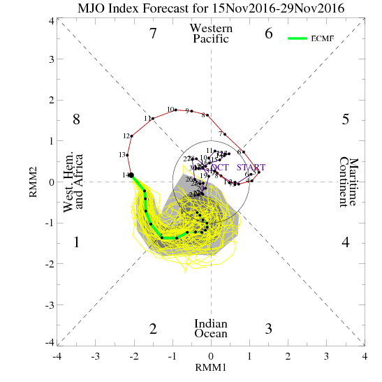
Currently the MJO is in phase 8 and heading shortly into 1. After this week’s and weekend’s more mobile and unsettled conditions, it looks like the upper pattern will become more blocked as we head through late November, perhaps a result of the MJO impacting the upper flow upstream. But also, the weak PV may be playing a part in allowing more blocked upper patterns to readily form too.
Also, in the near term since the beginning of October, there has been a rapid and above normal advance in snow cover across Siberia, which has extended further west into eastern Europe at times since early November too, though this part of Europe shows signs of warming up next week. The advanced and above normal snow extent across Eurasia combined with warmer than normal arctic with low sea ice extent is favouring a strong Siberian high and weakened Polar Vortex, which may ultimately have larger scale impacts on the upper circulations of the atmosphere as we head into winter. A strong siberian high can trigger atmopheric waves to propagate upwards that can cause a Sudden Stratospheric Warming (SSW) which can trigger the Polar Vortex to self-destruct or at least be displaced and lead to cold outbreaks for the UK.
Conclusion for early winter prospects
So concluding. There is a weakened polar vortex so far this autumn, which may be attributed to record warmth over the arctic this autumn linked to low arctic sea ice extent. The warm arctic, I think, could be the biggest factors that's producing a weak PV, against the background of QBO which would suggest otherwise. The high Eurasian snow extent, weak to neutral ENSO, favourable north Atlantic SST profiles are other longer term points to weaker PV and jet stream that may lead to a blocked and cold start to winter too. However, there are more short-term drivers such as the occasional favourable phases of the MJO which maybe more active this year thanks to a weak/neutral ENSO and high Eurasian snow extent that may favour periods of more blocked and colder weather as we start winter too.
December 2015, which was the warmest on record for the UK as a whole, since records began in 1910, with daffodils coming into flower and animals delaying their hibernations. Last Decemeber will probably be remembered more for the rain across northern and western areas, with record December totals following a succession of named storms. Storm Desmond brought unprecedented flooding to the Lake District, followed by Storm Eva then Storm Frank – which brought more gales and heavy rain leading to mayhem. But, this December, the start at least, looks to have a higher chance of more blocked, colder and less stormy weather – thanks to the weak Polar Vortex and weaker more wavy jet stream across the N Atlantic and Europe.
But, in the near term, it is turning unsettled, colder and windier, it may even be stormy on Sunday for some, as GFS persistently models a deep low crossing southern England. Before the weather calms down next week, with hints that blocking high pressure will form over or north of the UK.