The latest weekly synoptic guidance update - Pretty typical late September weather, with spells of wind and rain at times.
Issued at 1000BST on Monday 26th Sept based on 26th Sept 00Z Model Runs
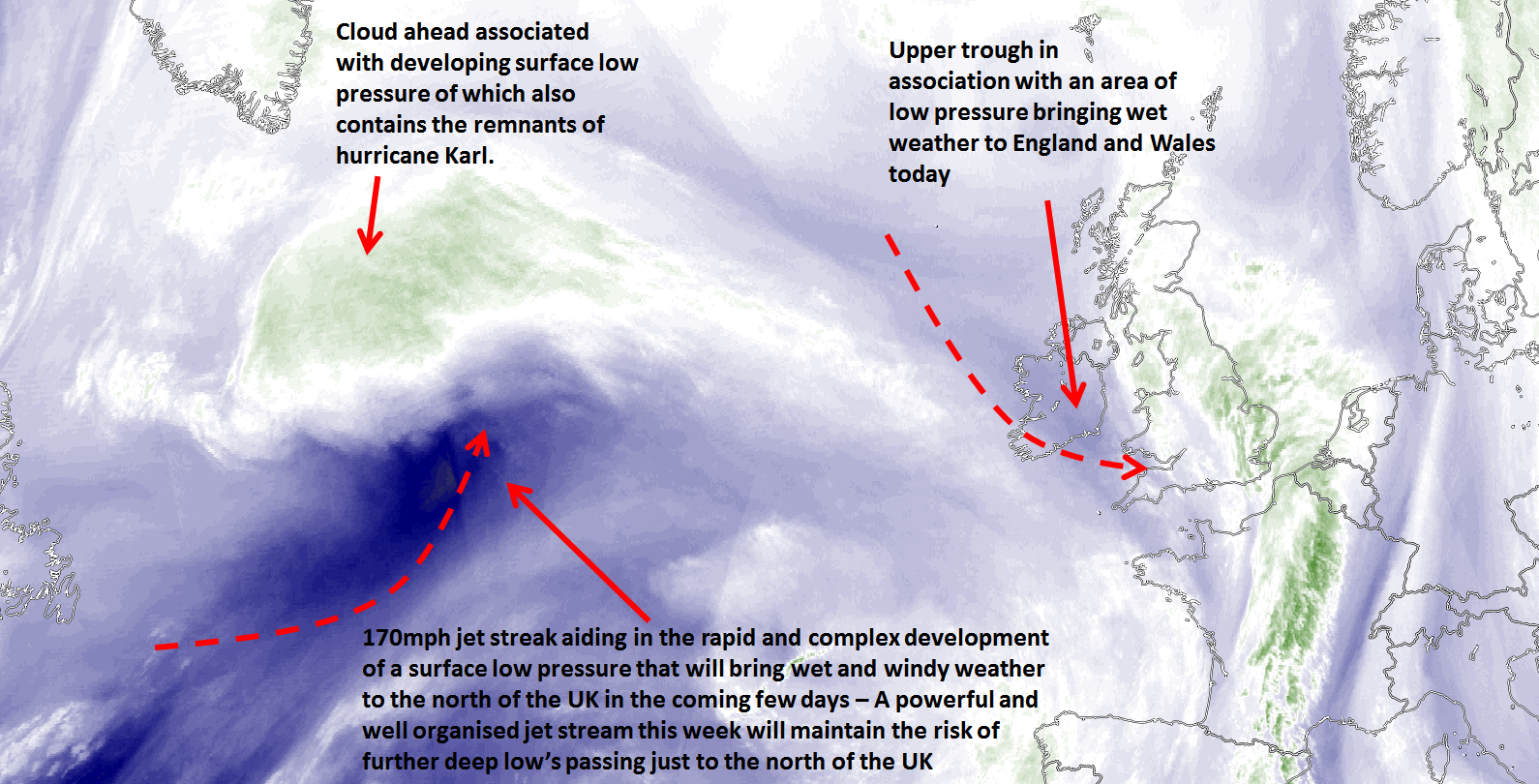
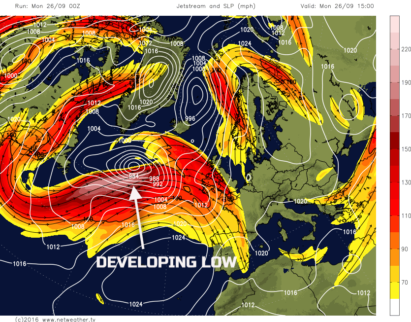
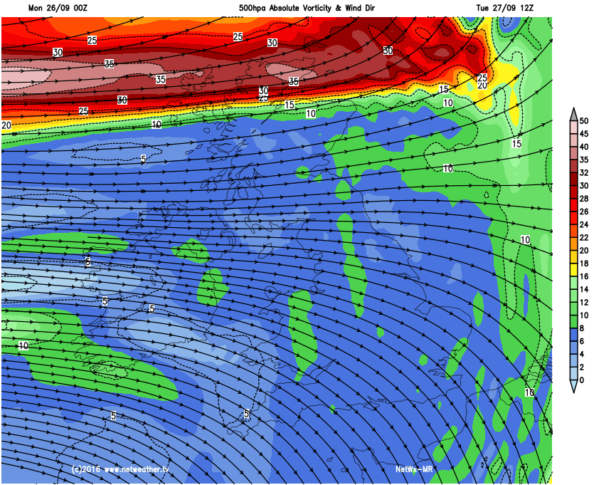
Mon 26th: Forecast model agreement is good regarding the synoptic developments through the remainder of Monday with the main GM’s (UKMO, GEM, GFS and ECMWF) all highlighting a relatively shallow area of low pressure moving into the UK from the south-west through the day. There is a certain amount of upper-level forcing in evidence with this low pressure and when combined with some warm air advection is likely to lead to some moderate or heavy rain at times, especially across parts of Wales. High-resolution models are in good agreement too for some central and southern areas of Wales to perhaps see up to 30mm to 40mm of rain before the end of the day. A zone of overcast and wet weather is expected across N England, parts of the Midlands, Wales and SW England throughout most of the day, whilst across the south-east it is generally drier, whilst brighter but showery conditions are expected further north. Developments upstream, over the N Atlantic, are being modelled relatively well as a powerful jet stream interacts with a surface low pressure and the remnants of Hurricane Karl to produce a deep low pressure that will bring wet and windy weather into the north and west of the UK late today onwards.
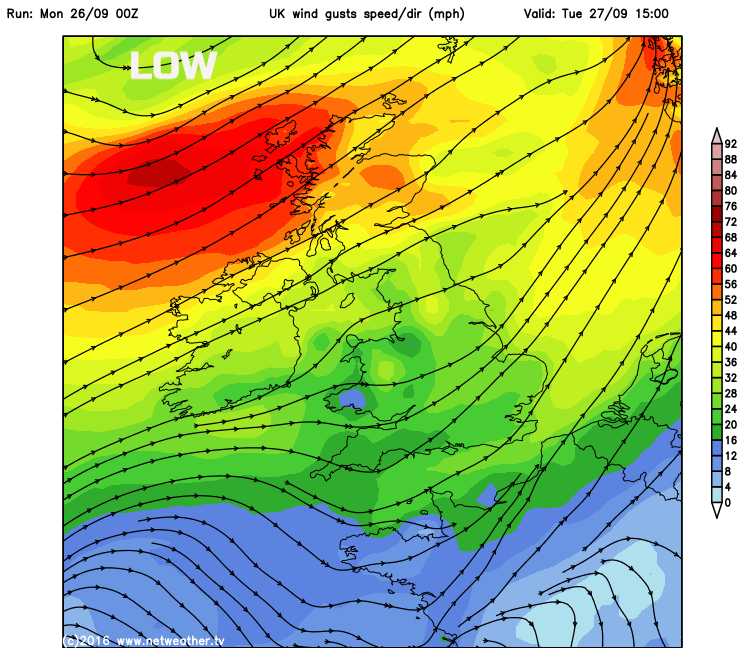
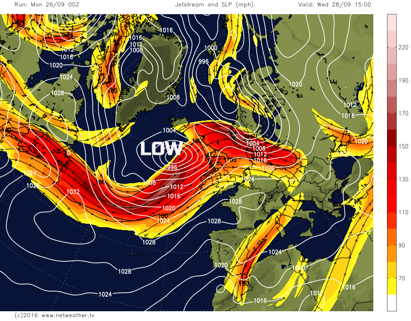
Tue 27th: Into Tuesday and the main jet stream is expected to move across the northern half of the UK, the surface low pressure developing upstream remains on the ‘cold side’ of the jet and hence allowing upper-level divergence to continue to take place and allowing the surface low pressure to deepen further. Most of the deterministic models track a low pressure to the north of Scotland through the day and this bringing a swathe of very strong winds on its southern flank to central and northern Scotland with gusts up to 50mph to 60mph certainly possible. Frontal systems associated with the low pressure will also move across the UK, but these are relatively weak features with little forcing and will bring mainly light rain or drizzle eastwards through the day, but with then a clearance following from the west as GPH rises in association with up-stream warm air advection. The swathe of strong winds can be seen in the graphic below, but note the lack of any real forcing associated with the fronts across most of the UK and hence the signal for relatively light precipitation.
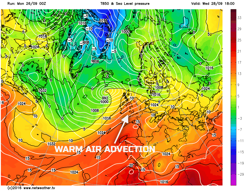
Wed 28th: By Wednesday and the UKMO, GFS, GEM, ARPEGE, JMA and ECMWF are all in broad agreement for another developing area of low pressure to be in evidence to the west of the UK. This feature is again likely to interact with the jet stream to allow for some significant developments and deepening as it tracks towards the north-west of Scotland through the course of the day. The weather across most of England and Wales though looks reasonable during the day as a build of pressure ahead of the developing low is likely to allow pressure to rise to 1020mb or more and with some significant WAA taking place. 850mb temperatures are set to peak on Wednesday at around +13C or +14C across England and Wales, and this will mean quite a warm day for late September.
However, attention is indeed drawn towards the developing low pressure of which will signal a renewed development of strong or gale force W or SW’ly winds across Scotland and perhaps N Ireland too. Some moderate and heavy rain will also develop across the north and west of the UK through the day. The developing low pressure can be seen on the below chart and also note the significant plume of warm air, as in evidence on 850mb temperatures across most areas of the UK, but noticeably so across England and Wales.
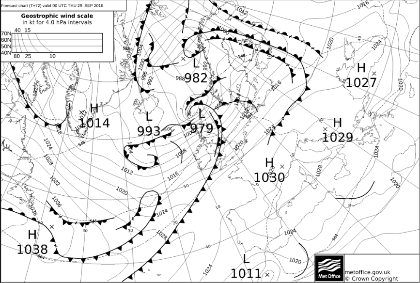
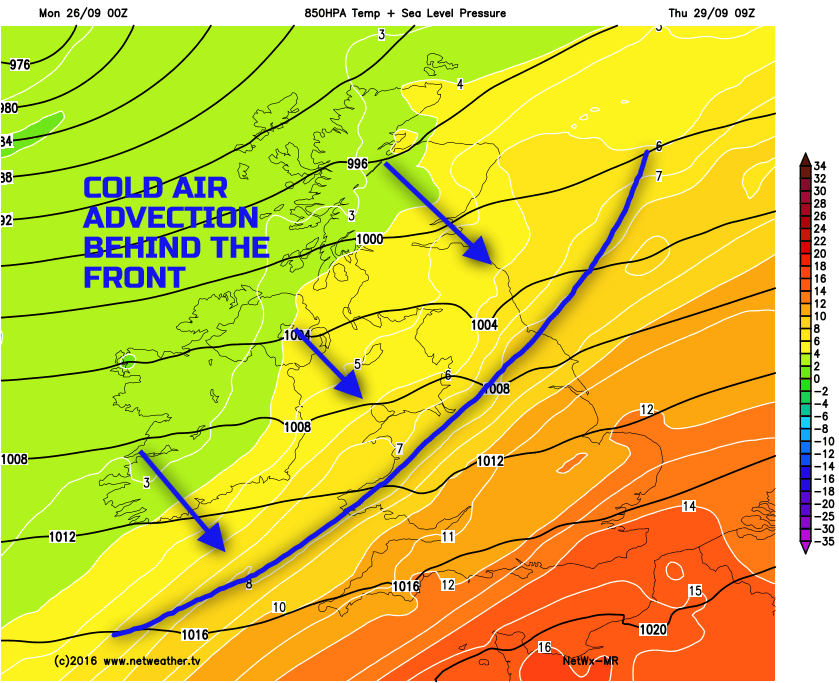
Thu 29th and Fri 30th: Overall the model agreement continues to be good, but the handling of the developing low pressure passing to the north of Scotland does have some uncertainties, primarily regarding the strength of the winds on the southern flank. However, confidence is high to suggest that Thursday will be a very windy day across Scotland with a tight PGF (pressure gradient force) in evidence across the north of the UK. With a likelihood of gales and perhaps severe gales, especially for N Scotland, nothing too unusual mind for late September, but still noteworthy. The low pressure will also have an associated cold front which will be moving south-eastwards through the day. This front may well be subject to frontal wave development and the timing of this frontal zone, as a result, is somewhat uncertain. However, the consensus is for a zone of mostly cloudy conditions, with some outbreaks of rain and showers moving SE through the day but perhaps not clearing SE England until later on in the day. Behind this frontal zone is a marked drop in 850mb temperatures and theta-e/w. 850mb temperatures drop nearly 10 degrees, and this will signal the arrival of more seasonal conditions, in terms of temperatures, to end the working week. At the moment Friday is likely to produce a mixture of sunshine and showers in a polar maritime air mass. The cold front moving SE on Thursday is in evidence on the overnight UKMO FAX chart for Thursday and clearly note the marked air mass boundary behind the frontal zone so that any warmth mid-week will be short-lived and confidence is high regarding this change to much cooler, fresher weather to end the week.
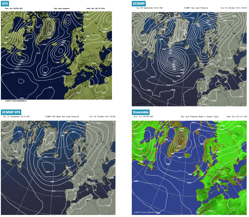
Sat 1st and Sun 2nd Oct: Into the opening week of October and, overall, there is reasonable model agreement for the broader synoptic pattern to be dominated by lower pressure to the north and north-west of the UK with a cool W’ly air mass over most areas. Details aside, a generally showery weekend is likely at the moment, but perhaps with some longer spells of rain to the north and west of the UK depending on any frontal development. Large-scale trough extension is signalled by the ECMWF and the GEM models, for example, into Sunday over the N Atlantic and this may allow the flow to back and with a build of GPH as Sunday progresses, so perhaps some improvement. But this development isn’t supported by the GFS and the UKMO models for example which maintain a more zonal and cyclonic pattern over the UK. At the moment the GFS and UKMO solutions are preferred and, as a result, a seasonal period of weather is expected for the opening weekend of October with cool/chilly temperatures and with some rain and showers possible.