


Atlantic Hurricane season has had a strange start this year, here's a guide to cyclones, post-tropical, extratropical, baroclinic and sub-tropical. With a glance at Alex and Bonnie.
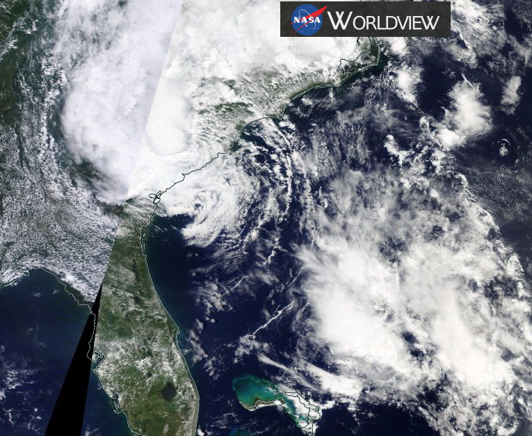
The Atlantic Hurricane season has seen 2 cyclones already this year, Tropical Storm TS Bonnie is now a post-tropical low and is currently bringing heavy rain to the Carolinas with the risk of flooding. Also super-early Hurricane Alex, which surprised everyone with his antics mid Atlantic in January. So as June starts, here's a reminder of the various names you'll see in the NHC (National Hurricane Centre) advisories and discussions.:
Cyclone:
An atmospheric closed circulation rotating counter-clockwise in the Northern Hemisphere and clockwise in the Southern Hemisphere.
Hurricane / Typhoon:
A tropical cyclone in which the maximum sustained surface wind (using the U.S. 1-minute average) is 64 kt (74 mph) or more. The term hurricane is used for Northern Hemisphere tropical cyclones east of the International Dateline to the Greenwich Meridian. The term typhoon is used for Pacific tropical cyclones north of the Equator west of the International Dateline. Indian ocean and Australasia use Cyclone only.
Tropical Cyclone:
A warm-core non-frontal synoptic-scale cyclone, originating over tropical or subtropical waters, with organized deep convection and a closed surface wind circulation about a well-defined centre. Once formed, a tropical cyclone is maintained by the extraction of heat energy from the ocean at high temperature and heat export at the low temperatures of the upper troposphere. In this they differ from extratropical cyclones, which derive their energy from horizontal temperature contrasts in the atmosphere (baroclinic effects).
Subtropical Cyclone:
A non-frontal low-pressure system that has characteristics of both tropical and extratropical cyclones. Like tropical cyclones, they are non-frontal, synoptic-scale cyclones that originate over tropical or subtropical waters, and have a closed surface wind circulation about a well-defined centre. In addition, they have organized moderate to deep convection, but lack a central dense overcast. Unlike tropical cyclones, subtropical cyclones derive a significant proportion of their energy from baroclinic sources, and are generally cold-core in the upper troposphere, often being associated with an upper-level low or trough. In comparison to tropical cyclones, these systems generally have a radius of maximum winds occurring relatively far from the centre (usually greater than 60 n mi), and generally have a less symmetric wind field and distribution of convection. Central Dense Overcast -A dense mass of clouds that covers and eyewall or the most tightly curved inner bands of a tropical cyclone.
Extratropical:
A term used in advisories and tropical summaries to indicate that a cyclone has lost its "tropical" characteristics. The term implies both poleward displacement of the cyclone and the conversion of the cyclone's primary energy source from the release of latent heat of condensation to baroclinic (the temperature contrast between warm and cold air masses) processes. It is important to note that cyclones can become extratropical and still retain winds of hurricane or tropical storm force.
Post-tropical Cyclone:
A former tropical cyclone. This generic term describes a cyclone that no longer possesses sufficient tropical characteristics to be considered a tropical cyclone. Post-tropical cyclones can continue carrying heavy rains and high winds. Note that former tropical cyclones that have become fully extratropical.as well as remnant lows.are two classes of post-tropical cyclones.
Extratropical Cyclone:
A cyclone of any intensity for which the primary energy source is baroclinic, that is, results from the temperature contrast between warm and cold air masses.
Remnant Low:
A post-tropical cyclone that no longer possesses the convective organization required of a tropical cyclone...and has maximum sustained winds of less than 34 knots. The term is most commonly applied to the nearly deep-convection-free swirls of stratocumulus in the eastern North Pacific.
This season started “remarkably” early with Hurricane Alex in mid January, Mid Atlantic. Moving out of the warm tropical or sub-tropical waters, energy was provided by baroclinic processes, which is how Alex was sustained for so long this winter.
Discussion about Hurricane Alex Jan 2016 NHC
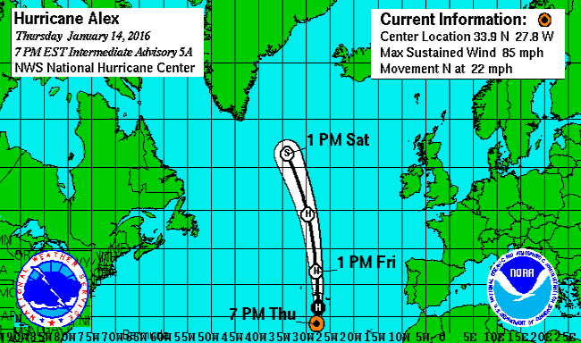
Alex is the first tropical or subtropical storm to form in January since an unnamed system did so in 1978, and is only the fourthknown to form in this month in the historical record that begins in 1851.
1100 AM AST THU JAN 14 2016Remarkably, Alex has undergone the transformation into a hurricane. A distinct eye is present,embedded within a fairly symmetric mass of deep convection. It is very unusual to have a hurricane over waters that are near20 deg C, but the upper-tropospheric temperatures are estimated to be around -60 deg C, which is significantly colder thanthe tropical mean. The resulting instability is likely the main factor contributing to the tropical transition andintensification of Alex. With these changes, the government of the Azores has issued warnings for most of the Azores islands.
Alex is the first hurricane to form in the month of January since 1938, and the first hurricane to occur in thismonth since Alice of 1955.
The hurricane is moving over colder sea surface temperatures of less than 20C. However, the cyclone should beginextratropical transition in the next few hours, and the global models suggest there will be enough baroclinic forcing to maintain hurricane-force winds through and after the transition despite the cold water.
500 AM AST FRI JAN 15 2016With Alex now moving over 16C sea-surface temperatures, and with colder water still aheadof the cyclone, transition to an extratropical cyclone should be complete within the next 12 hours. However, global models suggest that there will be enough baroclinic forcing to maintain hurricane-force winds after transition occurs despite the cold waters of the north Atlantic.
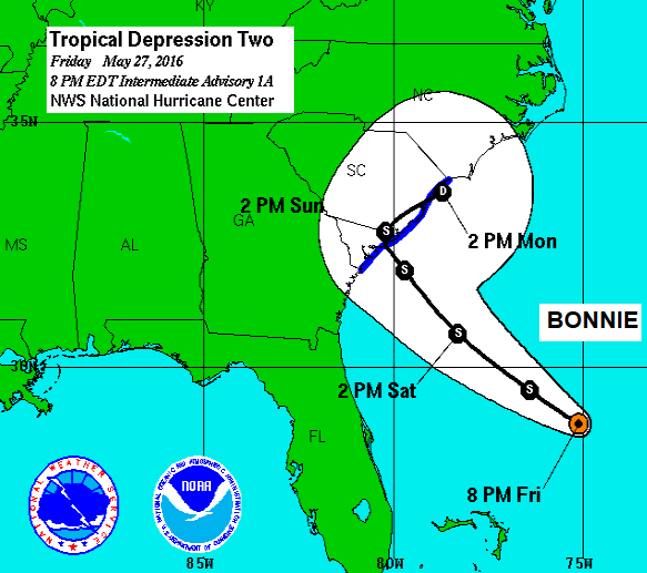
TS BONNIE
Second named storm Bonnie has followed a more traditional path starting as a Tropical disturbance to Depression to Storm (to Hurricane/Major Hurricane), now post-tropical/remnant low. Colin will be next List of names from NHC
The 2016 seasonal forecast from NOAA doesn't show anything extreme, with a near normal hurricane season expected. However, there have been difficulties with the hurricane season outlook, whether there will be reinforcing or competing climate influences on tropical storm development. More info here.
Last Year
For the 2015 season, 11 named storms formed in the Atlantic basin. Four of the storms became hurricanes, and 2 reached major hurricane status Joaquin and Danny. There was also one unnamed tropical depression.
The number of named storms, hurricanes, and major hurricanes was only a little below the long-term average activity levels of 12, 6, and 3 (storms/H/MH) respectively. Many of the named storms were relatively weak and short-lived and 2015 was a below-average season.


