After a late reminder of winter over the past week, this blog looks at the prospects of early summer temperatures by the end of next week, with temperatures hopefully reaching reach 20C in the south.
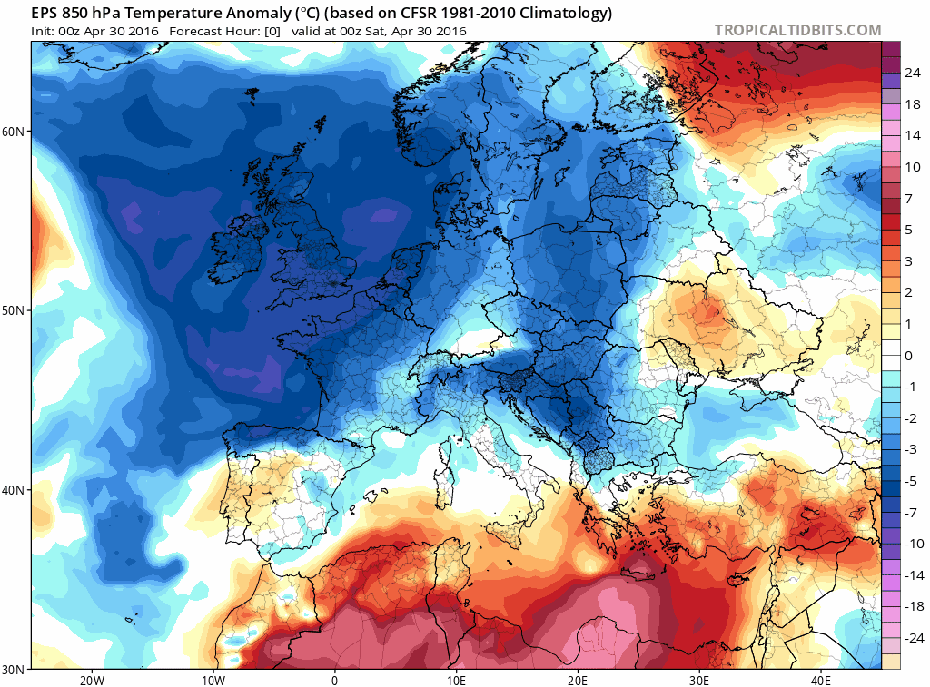
This April has seen some unseasonably cold weather in the last few weeks, with snow falling even in the south in the last few days.Though it may end up being just a degree or so below average at the most across the UK as a whole, UK Met Office provisional figures for April 2016 (1st-27th) have a mean temperature of 0.7C below average, though with still three days to go after that. The Netweather Temperature Tracker - based on the Central England Temperature series, is -0.16C departure from the CET average.
As we head through the Bank Holiday Weekend, it remains unsettled, with sunshine and showers on Saturday, then bands of rain accompanied by windier conditions spread across the UK on Sunday and Bank Holiday Monday. But after another cool day on Saturday and another cold night to come Saturday night, we do see an uptick in temperatures for the second half of the long weekend, with afternoon highs reaching 13-16C in the south, 10-12C in the north on Sunday.
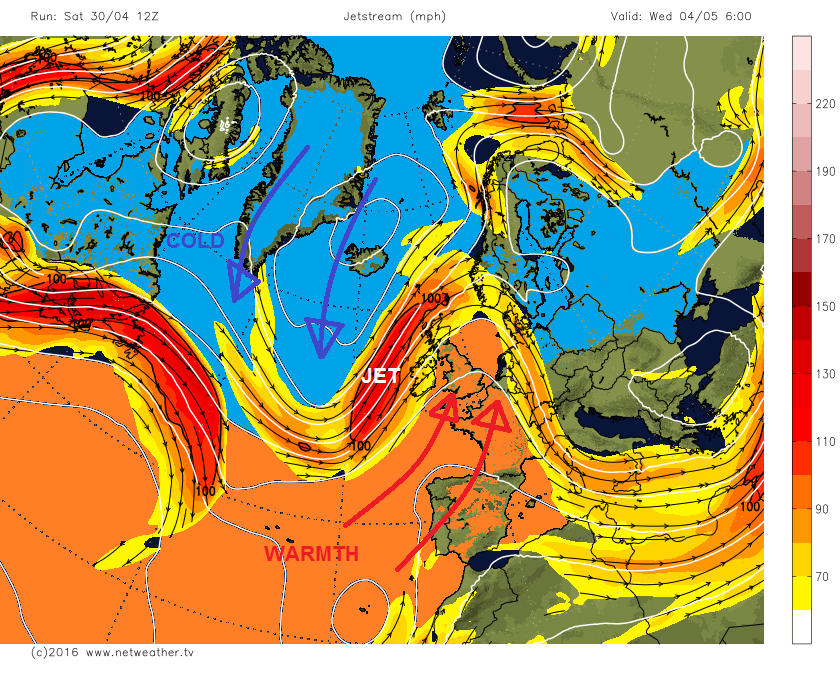
However, it looks like turning warmer still by the end of next week, particularly in the south. This is thanks to the jet stream finally lifting north through next week, to allow high pressure to build in from the southwest with the UK finally on the warmer south side of the jet stream rather than the cold north side of the jet as the past week.
Jet stream moves north of the UK, allowing warmer air to flood in from the southwest
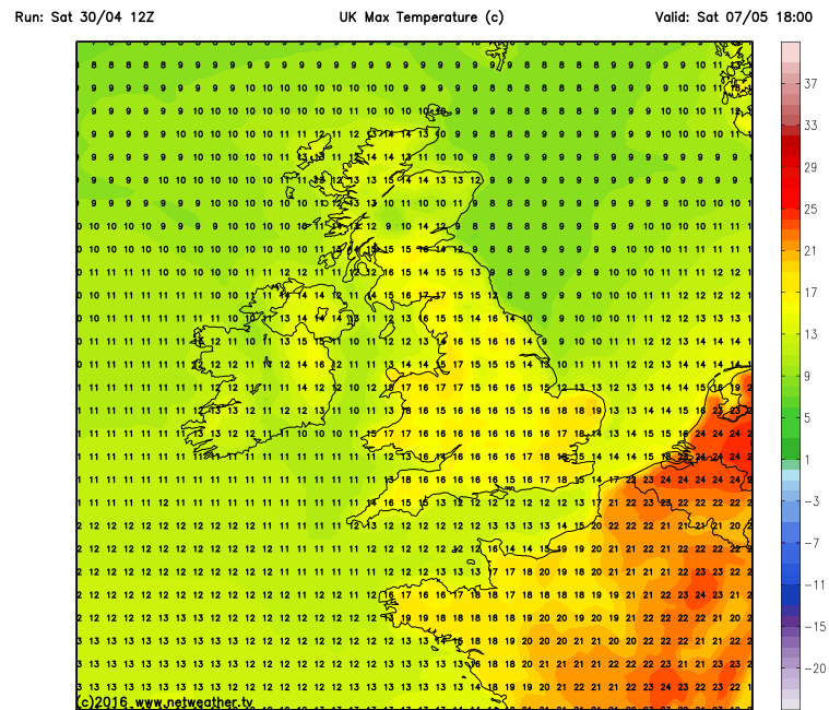
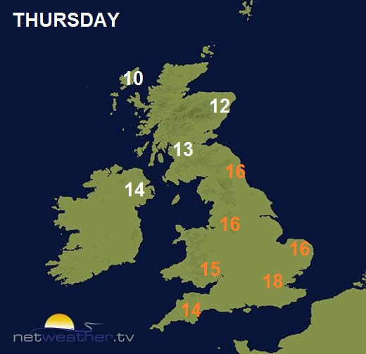
High pressure builds in from the Atlantic across southern Britain and France by mid-week, with rain confined to the far north of Britain and dry elsewhere. Towards the end of the week, the area of high pressure drifts east to be over Germany and Poland, while pressure falls to the west and southwest towards western Iberia. This allows winds to start to come up from the south, a much warmer direction than we have been used to recently. So temperatures on Thursday perhaps reaching 16-18C across England and Wales, then warmer still Friday – when they could reach 20C in the southeast, 16-18C elsewhere as far north as the central belt of Scotland.

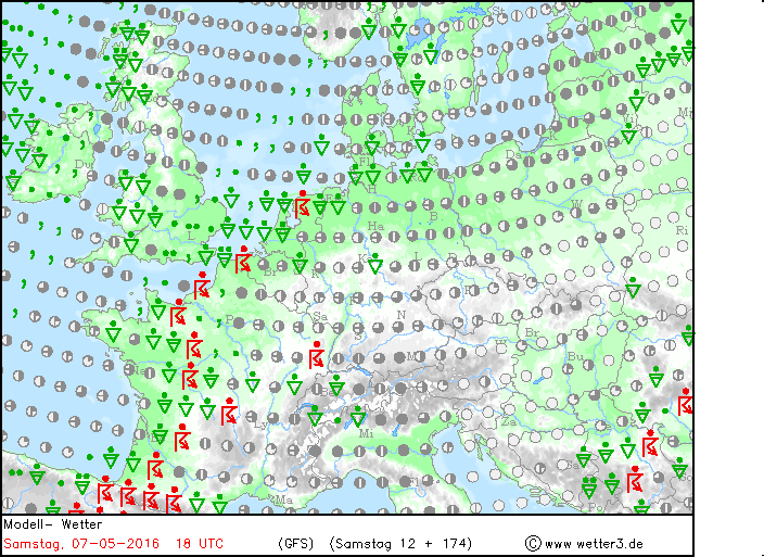
Some uncertainty for next weekend, though it is at least looking warmer than this one, as a deep trough becomes slow-moving close to the west, while pressure is high to the east, which will continue to drag in a warmer south or southeasterly flow off mainland Europe. The uncertainty between weather models lies with how settled it will be. 12z GFS still fairly warm over England and Wales, with temps in the high teens, though breaks out showers for the weekend, perhaps thundery towards the SE on Saturday. The model run before, the 06z GFS, was keen to bring an area of low pressure N/NE from the Bay of Biscay for Saturday bringing rain and wind north with it across most parts, followed by drier and brighter conditions from the south on Sunday with rain confined to the far north. 00z GFS had an area of low pressure moving northeast on Saturday, bringing with it showers on Saturday followed by drier conditions, fairly warm in the south. 00z ECM, on the other hand, sends rain north from the Bay of Biscay further west across Ireland and the western side of mainland Britain, dry, bright or sunny and warm further east - probably the warmest and driest of the two models for next weekend.
12z GFS breaks out showers on Saturday 7th May, but still fairly warm