


A look at how the weather is likely to shape up as we see out the last week of meteorological autumn and head into early winter.

Provisional figures from the UK Met Office suggest the first half of November (1-15) had maximum daily temperatures 3.8C above the UK average. With the start of the month the second warmest in Central England Temperature (CET) data set which began in 1772.
But after the unseasonably warm first half to November, we were reminded over the weekend that winter is nearly upon us, with a dramatic change as strong and bitter arctic winds with snow spread down from the north.
Temperatures fell to -6C again Sunday night in Oxfordshire, with temperatures widely below freezing across many areas bringing a widespread frost. However, it will turn gradually less cold through this week, as we lose the cold arctic feed and pick up a milder flow from the west. Over the weekend, average daytime temperatures around 5C, but this week temperatures will recover during by day. with temperatures averaging at around 8-10C. Wednesday will briefly see a return to cooler conditions, especially in the north, as winds turn northwesterly for a time. But it turns milder again from Thursday, as winds turn southwesterly, with some spots in the west on Thursday and Friday perhaps reaching 11-13C, as a ‘dome’ of milder Tropical maritime (Tm) air spreads in from the west with a ridge of high pressure.
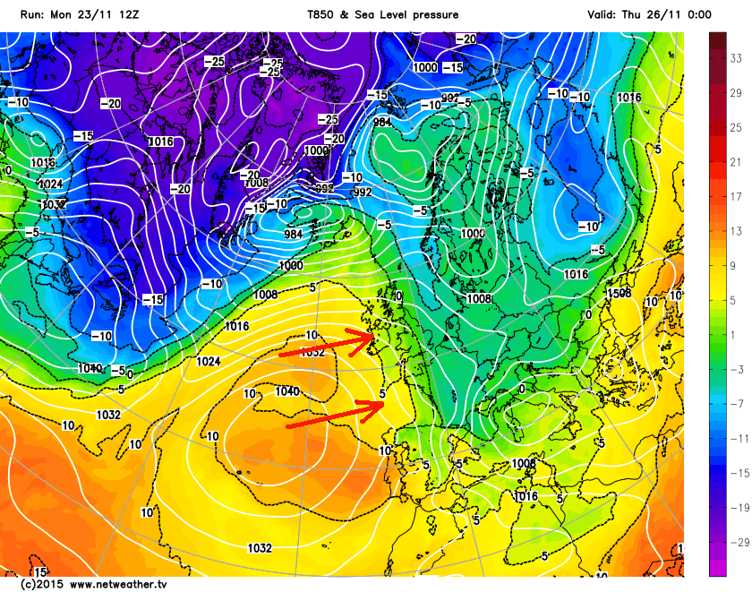
So turning less cold and there will be some spells of rain and some showers too this week. But unlike last week, where parts of NW England saw flooding, rain amounts don’t look too concerning this week, with a band of rain moving through later today/overnight followed by showers Tuesday and Wednesday. Drier on Thursday and Friday, as a ridge of high pressure slips by, before another band of rain arrives from the west for the end of Friday.
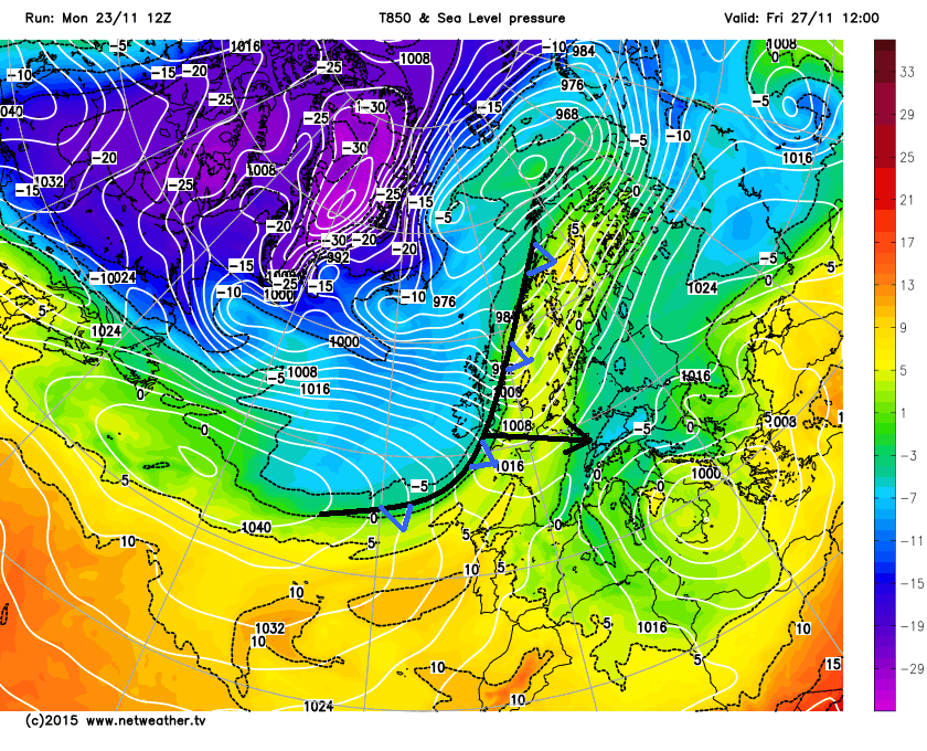
This band of rain forecast by models to arrive later on Friday marks a sharp cold front moving east, with a wedge of a cold Polar maritime (Pm) air (850mb temperatures below -5C) sweeping across most parts behind the cold front Friday night into Saturday, so another cold Saturday possibly on the way. Though as the air is Pm with a long sea track rather than Arctic maritime (Am) straught from the arctic, it may be more of a struggle to get snow falling to lower levels across central and southern areas as, unlike last Saturday, the cold air trails the cold front bringing precipitation. Wintry showers following the cold front in the north likely to bring snow here though, particularly over the hills.
The same rinse and repeat pattern of colder Pm incursions, with milder Tm spells in between, looks to play out as we head into early December too. This is thanks to a strong and progressive westerly upper flow pattern over the Atlantic and back across N America and the north Pacific, typical of strong El Nino response for early winter, which looks to show no signs of relenting at the moment. Though the progressive flow will have some transient troughs and ridges pushing east - which will allow brief cold shots across the UK in between milder interludes. But unless we see a dramatic change in the 500mb pattern, e.g. the strengthening tropospheric vortex (which drives storminess across the Atlantic towards the UK) gets nudged from its position over Greenland, then assume this pattern will continue.
Deep 500mb trough/low heights over the Greenland & Iceland vicinity still at day 10 on the ECMWF EPS mean a strong zonal (west to east) flow across northern Europe, with little opportunity for any sustained cold and wintry weather.
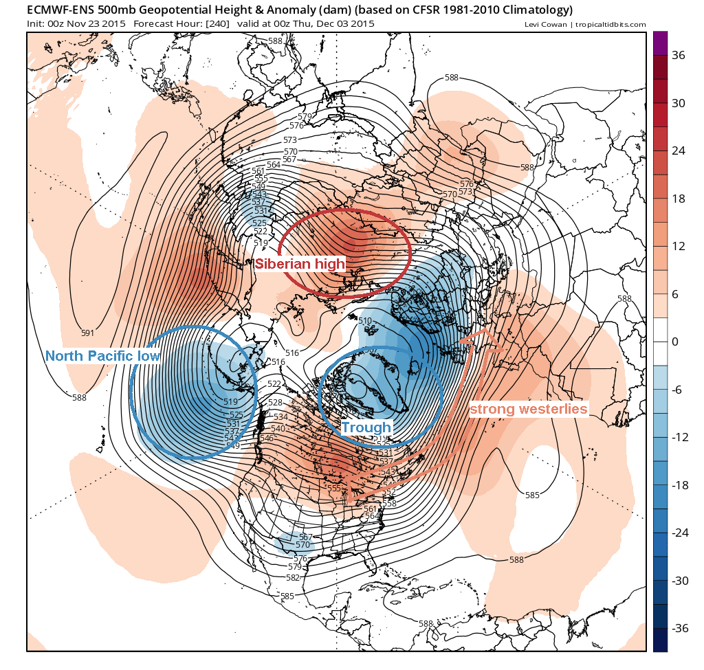
Looking for hints of what could change this pattern as we head into early Winter, there are a few straws to clutch, though which come with the usual caveats. These potential drivers for change are the Siberian High anomaly and El Nino.
With regards to the Siberian High (see chart above), the American GFS weather model and it ensemble system (GEFS) along with the European ECMWF weather model and its ensembles prediction system (EPS) have been signalling a persistent positive 500mb height anomaly or ridge of high pressure over Siberia.
This blocking area of high pressure is likely driven by above average snow extent across Eurasia since October creating a cold surface high. Also, the strong El Nino this autumn has favoured a strong north Pacific low (see chart above). Both of these help enhance poleward heat flux or vertical wave propagation – which weakens the Polar Vortex (PV) that would otherwise keep cold arctic air bottled up at high latitudes. This gradual and persistent assault on the PV, eventually creates a weaker and wavier upper flow configuration. The wave activity propagating upwards from the Siberian High and El Nino forcing also increases the chances of a sudden stratospheric warming (SSW) which weakens Polar Vortex in winter.
At the moment, the tropospheric polar vortex is modelled to strengthen and shows no signs of weakening for now. This is partly down to the westerly phase of the Quasi Biennial Oscillation (QBO) helping to strengthen the stratospheric polar vortex. But the impacts of El Nino and Siberian snow cover may eventually have an effect on the upper flow and perhaps disturb the polar vortex enough to favour a greater chance of colder patterns developing over northern Europe including the UK, as cold air dives south. But this may not occur until later in the winter. A wild card is the Madden Julian Oscillation (MJO), which is an area of convection that circumnavigates the equator and creates Rossby wave trains which can induce blocking in mid to higher latitudes of the northern hemisphere. But, The MJO varies signficantly based on the ENSO signal. It is most active during an ENSO neutral year and when the la nina or el nino is weak. When either is strong, the ENSO signal often overwhelms the MJO convection. Not surprisingly, the current MJO signal is weak and like to remain at low amplitude for the foreseeable. So not likely to override other drivers for now, unless El Nino weakens in the New Year.
Analog years with a previous strong El Nino running into winter suggest that the majority of prolonged cold and wintry spells that happened in those years occurred from later December or the New Year through January and February. Add this to the fact that QBO is an unfavourable westerly phase, I think the likelihood, for now, is near-to-slightly above average temperatures in December, with only a few short-lived wintry events – due to the strong Polar Vortex and subsequent northerly storm track keeping cold air bottled up to the north of the UK.


