


Latest In-depth Analysis looking at the heatwave developing by mid-week which looks to last until Sunday. Temperatures reaching the low 30s and a risk of thunderstorms.
Monday starts the week feeling like a fairly normal warm and sunny summer's day for many with fairly comfortable temperatures this afternoon, with temperatures reaching 20-23C inland across England and Wales, nudging towards 24-26C in London and southeast England, cooler along southern facing coasts where we have an onshore southerly breeze. Scotland and Northern Ireland are somewhat cooler and fresher with more in the way of cloud and some patchy rain.
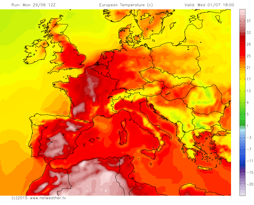
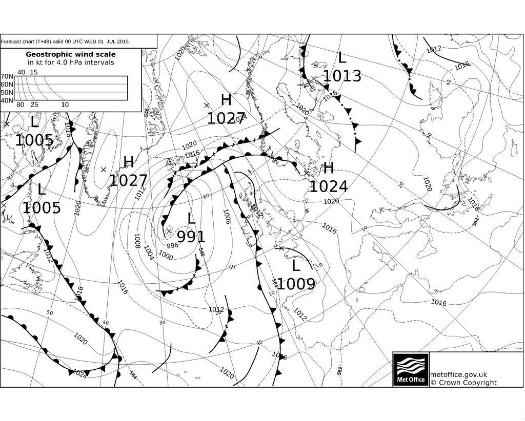
However, on Tuesday, slow-moving low pressure system extending south over the Atlantic to the west and SW of the UK will drag in an increasingly warm/hot southerly flow from France and Spain, temperatures look set to reach 40C (104F) in the afternoon across the Bordeaux area and other parts of SW France. So with this warmth pumping north across southern and central Britain on Tuesday, we will see temperatures climb to around 30C in London, 26-27C in Manchester, Leeds and Newcastle, 25C in Cardiff - cooler and fresher still across Scotland and N. Ireland - where highs of 18-21C are more likely.The increasing surface heat and slight cooler air aloft/increasingly cyclonic flow from the west could trigger some isolated heavy showers or perhaps thunderstorms across northern England, southern and eastern Scotland by early evening, rumbling through into the first half of the night, before clearing off the east coast of Scotland early Wednesday morning.
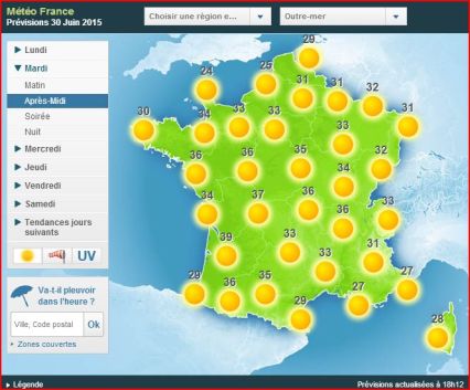
Heat across France Tuesday afternoon:
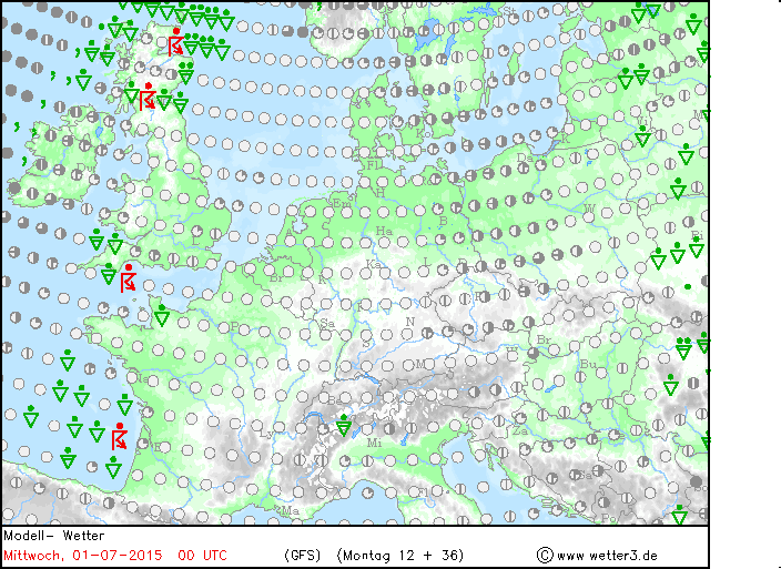
Storms developing across northern parts Tuesday evening and later across the SW as thundery low/trough moves north:
Tuesday night looks like being oppressive and uncomfortable for many, with temperatures falling no lower than 20C in London, 17-19C in other towns and cities across England, Wales and southern Scotland. We may see a few elevated heavy showers or thunderstorms drift north across SW England and south Wales during the night too, as a thundery low/trough moves north from the Bay of Biscay.
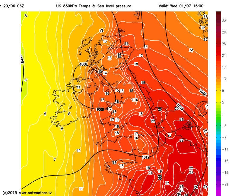
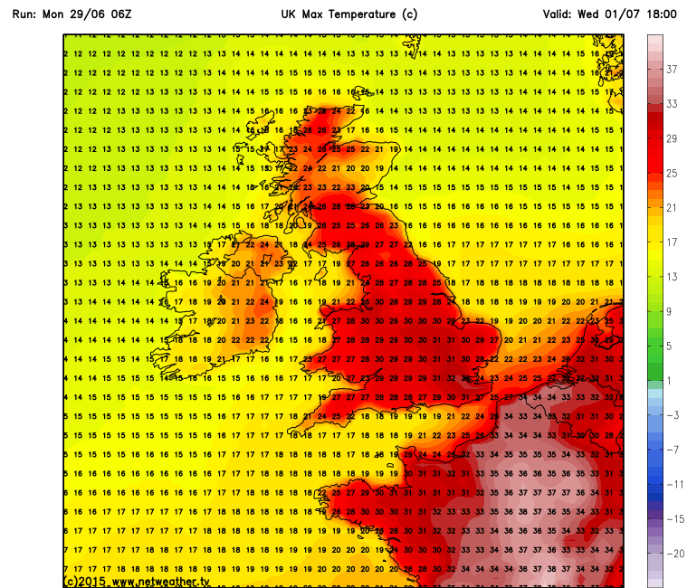
Then Wednesday looks like being the hottest day of the week, as the hot southerly plume continues to feed across the UK. 850mb temperatures (about 1500m/4900ft above sea-level) look to reach 20C for a time across southeast England Wednesday afternoon, which doesn't happen often in summer. On the ground, we are looking at maximum temperatures reaching 33C in London and The Home Counties, even 1 or 2 degrees higher in a few spots. Elsewhere, we are looking at highs of 29-30C in Manchester and Birmingham, 26-27C in Cardiff and Glasgow, a cooler 22C in Belfast. Many places will remain dry, sunny and hot, but there will be risk of some isolated thunderstorms drifting north across Wales, The West Country and The Midlands before perhaps developing a little more widely later across northern England along with parts of Scotland Wednesday evening and Wednesday night. These storm triggered by isentropic lift of warm moist plume into cooling air aloft as heights/pressure fall from the southwest helped by one or two shortwave troughs moving north in the strengthening southerly flow aloft. If you catch a thunderstorm it maybe accompanied torrential rain, hail, gusty winds and frequent cloud-to-ground lightning.
Very warm air at 850mb and surface temps Weds afternoon:
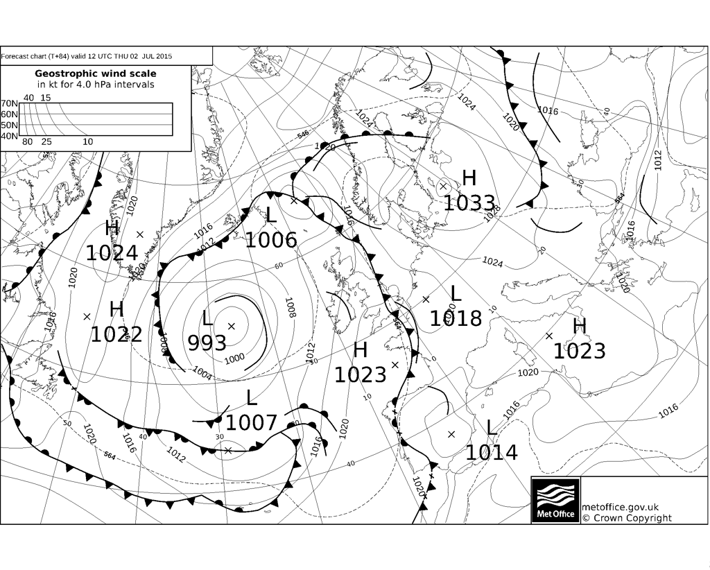
A cold front marking the western edge of the plume will clear slowly east across the UK Wednesday night and Thursday morning to lie somewhere over eastern England by Thursday lunchtime. So overnight thunderstorms across Scotland and northern England will clear away east into the North Sea early Thursday morning, followed by fresher conditions and mostly dry and sunny day, though still a risk of one or two heavy showers or thunderstorms developing in the afternoon over Scotland. Further south, any isolated storms drifting up from the south overnight generally clearing first thing as the cold front clears east, though we could hang on to some storms in the morning across SE England and East Anglia before the cold front clears here in the afternoon, though some uncertainty over how quickly the front clears east. Generally feeling a little fresher and less hot, though we could still see highs of 27-29C across East Anglia and SE England, a fresher 22-25C across the rest of England and Wales. 18-21C across Scotland and Northern Ireland.
Cold front clearing eastern England Thursday afternoon to fresher conditions from the west:
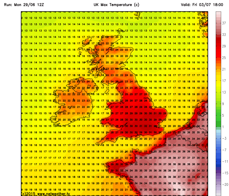
However, the heat and humidity looks set to return across southern parts again on Friday and Saturday, as warm and unstable plume tries to push up from the south again across southern England. Temperatures up to around 30-32C across S and SE England Friday afternoon according to 12z GFS and a risk of thunderstorms moving up from the south in the evening and overnight here. Some storms also perhaps developing across northern and western parts of England and Wales on the NW edge of the new plume, all these storms developing more widely and moving north into Scotland into Saturday - which looks, for now, to be a very warm or hot day across England and Wales, with a risk of further storms in places - temperatures in the low 30s across SE England and E Anglia on 12z GFS. Mid to high 20s northern and western England, low 20s Wales, Scotland and Ireland/N Ireland.
Friday max temps:
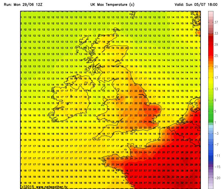
For now, looks like turning cooler and fresher from the west everywhere on Sunday, with temperatures back into the low to mid 20s across SE England to the high teens across the north and west. It's looking mostly dry though on Sunday. Temperature back to normal next week under a more cyclonic southwesterly flow, with outbreaks of rain or showers spreading east at times with sunny spells in between.
Sunday's cooler and fresher everywhere:
I may update with further blogs over the next few days with regards to the heatwave and also look out for storm forecasts from Netweather as we see an increasing risk of thundestorms http://www.netweather.tv/index.cgi?action=convective;sess=


