


El Nino has intensified from weak to weak-to-moderate with potential of a strong El Nino that could persist throughout 2015 - but how will this impact the weather?
El Niño intensified from “weak” in April to “weak-to-moderate” in May, the National Oceanic and Atmospheric Administration’s Climate Prediction Center said. Officials said there is now an 80% or greater chance that El Niño conditions will persist through the latter part of the year — up from more than 60% in April’s forecast. There is an approximately 90% chance that El Niño will continue through Northern Hemisphere summer 2015, and a greater than 80% chance it will last through 2015.
What is El Nino?
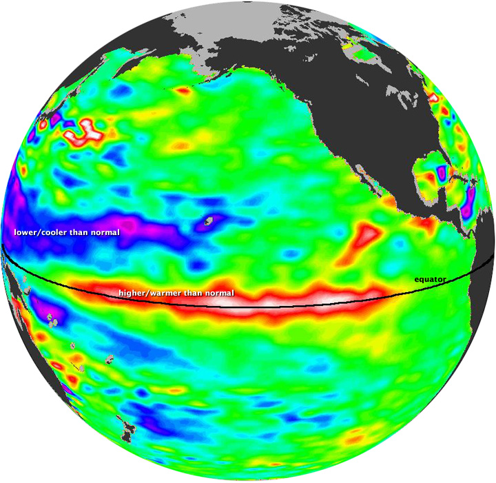
El Niño is the warm phase of the El Nino Southern Oscillation (commonly called ENSO) and is associated with a band of unusually warm ocean water that develops in the central and east-central equatorial Pacific. Whereas El Niño’s opposite, La Niña, is characterised by unusually cool ocean water in the equatorial Pacific.
El Niño is a periodic ocean-atmosphere coupled oscillation that leads to parts of the central and eastern tropical Pacific becoming warmer than normal every two to seven years, on average, leading to large-scale changes in sea level pressure, sea-surface temperatures, precipitation and winds, not just in the tropics but in many other regions of the world.
El Niño is officially considered when the sea surface temperatures in a key region of the central and eastern tropical Pacific ocean reaches at least 0.5°C, or about 1°F, warmer than average.
What’s in the name?
El Niño means ‘The Little Boy’ or ‘Christ child’ in Spanish. This name was used for the tendency of the phenomenon to arrive around Christmas. It was originally recognized by fisherman off the coast of South America as the appearance of unusually warm water in the Pacific ocean, occurring near the beginning of the year. La Niña means ‘The Little Girl’. La Niña is sometimes called El Viejo, anti-El Niño, or simply "a cold event" or "a cold episode"
What causes it?
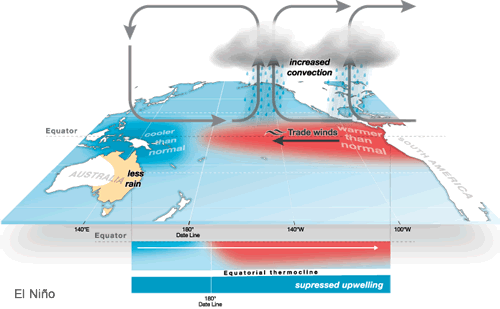
Typically, easterly ‘Trade Winds’ winds blow along the equator in the Pacific, this normally piles up warm water in the western Pacific – while in the eastern Pacific, cooler water from deeper in the ocean gets pulled up to replace the warm water pushed west.
However, during an El Niño, these trade winds weaken, so the warm waters slide back towards the central and eastern Pacific, in what is known as an equatorial Kelvin Wave, so the central and eastern tropical Pacific waters get warmer, a hallmark of an El Niño. These warm waters have a positive feedback in weakening the trade winds further, and even reversing the winds, so strengthening El Niño.
Climate scientists use buoys floating in the Pacific amongst other data, such as from satellites, to record changes in sea surface temperatures, sea currents, wind direction, etc – which are fed into complex computer models that can predict El Niño. Though these computer models, at the moment, are not able to accurately predict the intensity or duration of El Niño more than a few months ahead.
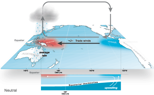
The 3 phases of ENSO: El Niño, Neutral and La Niña, Images courtesy of Australian Bureau of Meterology (BOM):
El Niño
La Niña
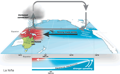
Neutral
When did it start, how long will it last and how strong will it be?
The warming of the eastern equatorial Pacific waters is quite a slow process, indeed there were signs way back in summer 2014 that a weak El Niño maybe developing. Indeed the UK Met office were heralding the onset of El Niño last July:
http://www.metoffice.gov.uk/research/news/2014/el-nino-2014-15
But it wasn’t until early March this year that the American NOAA’s Climate Precidiction Center (CPC) and Australian Bureau of Meteorology (BOM) officially declared the early stages of an El Niño evolving, much later than expected.
Now CPC and BOM scientests suggest that El Nino is increasingly likely to persist through the summer, autumn and possbily winter, and may be one of the strongest ones in almost two decades.
Historically speaking, El Niño events tend to develop during the period Apr-Jun and they tend to reach their maximum strength during Dec-Feb, typically persist for 9-12 months, though occasionally persisting for up to 2 years. These events occurring every 2 to 7 years on average.
Eight El Nino events which have been reported since 1980. The events occured in the following years: 1982-1983, 1986-1987, 1991-1992, 1994-1995, 1997-1998, 2002-2003, 2006-2007, 2009-2010.
The strongest El Niño event that has ever been recorded occurred in 1997- 1998. Its impact was felt in many parts of the world. Droughts hit Indonesia and other islands in the western Pacific, triggering uncontrollable forest fires. Peru suffered deadly flooding. Record-breaking rainfall hit the US state of California, causing mudslides and flooding. Kenya too, was hit by severe flooding.
Impacts of El Niño on global weather:
El Niño creates a ‘sea change’ in atmospheric circulation. Wherever there is a warm pool of water in the tropical Pacific, thunderstorms are most numerous, as they require warm and humid air at the surface to fuel them. Normally, the warmest waters are in the western Pacific, so this is where thunderstorms are most persistent. But during an El Niño, the most persistent area of thunderstorms will shift from the western to eastern tropical Pacific with the warmer water. The change in trade winds and shift in area of most numerous thunderstorms can force changes to atmospheric circulations not just over the tropical Pacific but also more globally too.
El Niño’s impact on northern hemisphere climate tends to be most felt during late autumn and the winter, but it must be emphasised that, El Niño is not the sole driver of the atmosphere and other atmospheric variables such as blocking patterns, sun spots, stratospheric warming, climate change and many other factors can all work in tandem with El Niño to bring our weather. So no two El Niños will be exactly alike. But El Niño Southern Oscillation (ENSO) is by far the most dominant feature of climate variability over on inter-annual timescales.
A strong El Niño is often associated with reduced monsoon rainfall (25% reduction on average) in the Indian sub-contintent, drought and wildfires in Indonesia, drought, wildfires and excessive heat in Australia. While further east it leads to above average rainfall and risk of flooding across South American countries bordering the Pacific, Argentina, southern US states from California through the Gulf States to the Carolinas, Kenya and southern China. Also El Niño has been implicated in increased typhoon activity in the NW Pacific and a slightly weaker than average cyclone activity over the Atlantic, including a reduction in hurricanes, due to increased wind shear aloft from more energy in the sub-tropical jet stream. These impacts are what is typically expected, but are not the rule.
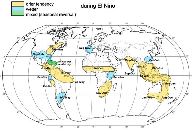
Precipitation impact during El Niño (image courtesy of the UK Met Office)
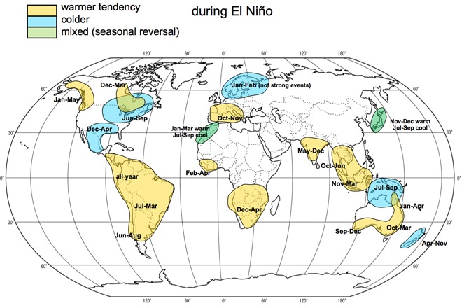
Temperature impact from El Niño (image courtesy of the UK Met Office)
Impacts of El Niño on European weather:
The impacts of El Niño on European weather patterns, including the UK, are not quite as clear-cut as in other parts of the world. Research suggests that El Niño has more of an impact during late Autumn and through winter. Historically, El Niño episodes have sometimes lead to colder, drier conditions over northern Europe (particularly later in the winter) and wetter, milder winters in southern Europe. Though there is some evidence that El Niño can lead to a more southerly storm track later in the summer and into autumn, with SW Europe wetter than average August to November.
During the last El Niño event in 2009/10, northern Europe, including the UK, experienced an exceptionally cold winter. However, that winter also coincided with a solar-minimum – which is know to increase the likelihood of cold winters. Europe had a mild winter during the El Niño of 2006/07, despite low sun spot activity at the time.
So, it should be stressed that El Niño does not automatically mean a cold winter for the UK, because history bears evidence that this has not always been the case during past events. So we can perhaps dismiss the attention-grabbing headlines from the tabloids recently, suggesting Britain will be sent into a deep freeze and will get battered by fierce snow storms in winter 2015/16. Obviously time will tell!
But globally, we may well see impacts from El Niño making news over the coming months. This could be, for example, flooding in Peru or exceptional heat, drought and wildfires in Australia. Globally, we could see an increase in global temperatures too, as has been the case in the past during El Niño events. So another warm year coming after last year, which was globally the hottest year on record. The 2014 average temperature was 1.1°F above the 20th century average according to the Japan Meteorlogocal Agency’s data. That edges 1998, the previous warmest year, by about 0.1°F.


