


Met. Office weather warnings now include likelihood and impacts. Jo's been finding out more about what that means and the challenge of communicating uncertainty of the forecast alongside the potential impacts.
February 2015
The Met. Office have just issued Yellow warnings for Snow across Scotland, N.Ireland and parts of N.England, no yellow snow jokes please we've heard them all before. What do these warnings mean and how are they put together.
Winter can be a busy time for weather forecasters. Snow, ice, heavy rain and gales all interrupting everyday life. Even when a high pressure bringing a settled spell to the UK, there are still issues with fog and low temperatures. In summer, heat can cause problems and intense rain fall from thunderstorms can throw up the need for warnings and alerts. At Netweather, the Alerts system automatically highlights heavy rain, strong winds etc. on the Home page. This is simply related to certain thresholds
Wind is currently set to 60mph, Rain is set to 10mm / hr
Snow is if any sleet/snow is detected, Lightning is if a single strike is detected over UK/Ireland/Channel Islands.
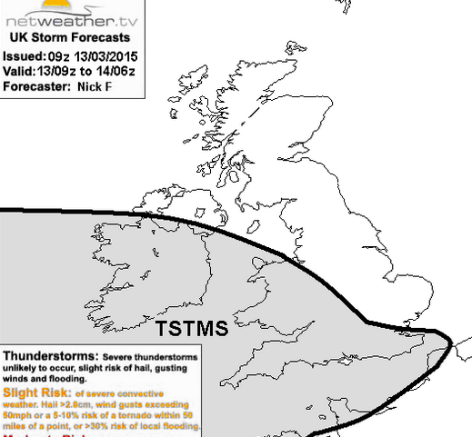
![]() There are the convective warnings done by Nick Finnis
There are the convective warnings done by Nick Finnis
Warning about UK thunderstorms
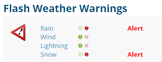
You may have seen the yellow or red banner across the top of the Home page which links to the Netweather warnings across the UK. You can sign up to receive any warnings for your region/nation by email.
There are many different types of weather warnings, a personal favourite is the Jersey Met service’s wind warning  How that man in the bowler hat struggles.
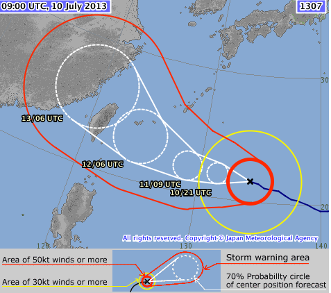
Typhoon and hurricane warnings can include a spread of possible tracks, rather then just one deterministic solution. This introduces the element of likelihood to a forecast chart.
Flagging up severe weather is a key part of the weather forecasters’ job. My other job is to cover the weather on STV (Scottish ITV) when their main presenter is off. The usual broadcast has time limits and a perceived audience with Today and tonight at mid-morning and Tonight and tomorrow for the evening bulletin. What I always have to keep an eye out for warnings and adapting the broadcasts. STV take data from the Met Office and as the National Met Service with the business of providing the NSWWS (National Severe Weather Warning Service), they have a duty to issue public weather warnings.
So at STV, I am a messenger of the Met Office weather warnings. Recently, I attended a Royal Met. Soc. talk at Edinburgh University about the whole Met Office warning system. And I am very glad I did because actually I didn’t understand them properly. As a result, I thought it would be worth looking at a few things: how they are created, who they are aimed at and all the processes behind them. With more explaination, that could then make them more useful and relevant.
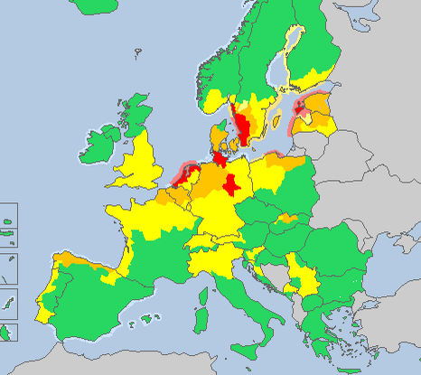
Historically, warnings related to strict meteorological thresholds. So, say the wind strength was forecast to reach 70mph, and then you might reach one level. If it reached 85mph, then the next level. This does still occur across Europe. If you look at the Meteo alarm page, (which is supported by the WMO World Met Organisation) there are warnings from different countries flagging up familiar rain/snow etc. and also avalanche, coastal waves, extreme low temperature/heat. Some of these are threshold based, fall below -15C in Slovenia and an amber warning pops up.
The M.O.warnings were adapted and given the familiar red/amber /yellow status (green for all clear) back in 2007, based mainly on Met. thresholds and likelihoods. Then in 2011, impacts were included. This was the bit I wasn’t clear on.
It isn’t just the public that use these warnings. They are very important to emergency services, local authorities, health, transport and energy sectors and over recent years the relationships between these agencies and the M.O. has grown. The Met Office decided that the most important aspect of a warning service is not how much snow will fall or how strong the wind will be, but what impacts will be caused by the weather.
Instead of just being ‘ THERE WILL BE HEAVY RAIN in Surrey’, ‘THERE WILL BE 70mph winds in Stirling’, it is the impacts of the heavy rain and the impacts of the gales that needed to be considered. Would the weather disrupt people’s day to day activities and that often depends on the area affected.
Why take this new approach?
Consider a forecast for 70mph winds. 70mph for the Northern Isles (more resilient to strong winds) or 70mph for central London (an urban environment). The actual impacts would be very different. Looking at 2cms of snow, either in the middle of the night or Friday evening rush hour. Again the impacts would be hugely different. These factors go in the warnings pot.
Another factor is likelihood, which can be influenced by lead time. Is this weather expected in 4 days’ time or tonight? Do all the models agree that a deep low pressure is heading for the UK or is the spread from Iceland to France? For snow, is it really cold or borderline, and the same for Ice where 1 degree can make a huge difference. Is this a rapidly deepening storm with a possible Sting jet feature, or just a deep low? Forecasting is never easy when just looking at the actual weather. Communicating the uncertainty of the forecast and the potential impacts is quite a challenge.
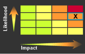
Showing this new process is quite tricky and is still being developed, especially for public understanding. The 3 colours have been kept, but they no longer reflect a worsening forecast. The colours now reflect a combination of impact and the likelihood of those impacts occurring. They are clearly linked to 5 types of weather, although lightning can be added onto a rain or snow warning. Ice and fog only go up to Amber

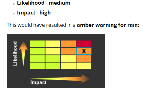
You may have seen the risk matrix on the MO warnings pages
This example was for a heavy rain event
So there is weather data being input, with the varying confidences we see all the time about forecasting the weather. And there is the impacts side. The Met Office works closely with partners across the emergency response community to understand how impacts affect their work and communities . And these discussions happen all the time, especially for the Amber and red warnings
A guide to the impacts for all 5 types of weather is available here http://www.metoffice.gov.uk/guide/weather/severe-weather-advice
It’s quite a long page, keep scrolling down to find snow and rain. This explains in detail, what kind of things would be happening if there was an Amber for Snow, or a red for Wind.
It is a guide and needs some understanding, so saying “our schools were shut and 3 tiles flew off my roof and we never had a red” is all very well with hind sight. When these warnings are issued, the resilience of the community area is key. N.England can cope with 1” of snow and clear the M62, but it might be that a lorry jacknifes. Then there are cars stuck overnight because the gritters can't get through. The resulting jam and media headlines don’t actually mean it needed a red. Also if an amber is issued for snow and all the roads are cleared, gritted, snow falls but everything runs smoothly, does that then mean it was over warne?. Pre-empting the impacts makes these warnings very hard to verify because hopefully, trouble is avoided.
Perhaps, what does need to be addressed is that some people still view that until there is a M.O. red warning, the weather isn’t going to be that bad. Also, that a yellow isn’t much to worry about or can just be ignored. Yellows can be used to give a heads up early on of possible severe weather. Amber does mean severe weather is on the way. The red level combines exceptional weather and widespread impacts, which the area’s resilience will be heavily strained
So, when one of the symbols changes from green for your area, make sure you have a look at the matrix too. It should answer the questions:
How likely is it that impacts will occur? What kind of impact is it going to have?
Stay in touch with the forecast, updates are issued all the time because these things change, that’s why we turn up every day.
The Met Office is currently the only Weather service in the world that uses an Impact based weather warning service.
Head to the Netweather forum, to discuss further. https://forum.netweather.tv/topic/82567-met-office-weather-warnings-yellow-amber-red/
In Weather discussion and Chat -- Netweather Homepage COMMUNITY tab
Royal Meteorological Society events


