Latest synoptic analysis looking at what's in store for Christmas week and beyond towards the New Year, including a potential winter storm this weekend.
A deep area of low pressure just SE of Iceland today will move slowly SE towards the northern and eastern North Sea over the next few days, before merging with low pressure complex over Sweden and Baltic by the end of Christmas Eve. To the south of the this low is a slow-moving cold frontal zone – separating mild and cloudy weather to the south over England and Wales and colder, clearer conditions across northern Scotland. Pulses of persistent and locally heavy rain look to continue near the cold front over the next few days, as it slowly slips south across England and Wales, before clearer and colder conditions finally push down to the south coast by Christmas Eve afternoon. To the south of the rain it will remain mild, cloud and windy, with patchy drizzle today and tomorrow. To the north of the rain, clearer and colder conditions will slowly move south across Scotland today and during Tuesday.
So by the afternoon of Christmas Eve, colder and brighter conditions should have pushed all the way to the south coast as the cold front clears here, with many areas seeing some sunshine to end the day, but we will also see some scattered squally wintry showers across northern and western Scotland, some of these accompanied by thunder and lightning and falling as snow over higher ground.
Christmas Day looks like starting off on a cold and frosty note, with many areas looking like waking up with at least a ground frost. The day itself is looking chilly, bright and breezy with winds from the north or northwest. Dry for most, as high pressure builds in from the west, but with low pressure just over the North Sea across Scandinavia – we could see some wintry showers affecting eastern Scotland and NE England, falling as snow over the hills and perhaps to lower levels too. So potential for a white Christmas here.
An even colder Christmas night will lead to a widespread hard frost to start Boxing Day, with temperatures perhaps falling as low as -4C to -6C widely in rural areas of the UK. Boxing Day itself is looking mostly dry, bright and chilly for all in the morning and remaining so across the east through the afternoon. But, a deepening area of low pressure looks to arrive to the northwest of the UK by the evening, with cloudy, wet and windy conditions spreading across western areas through the afternoon and evening.
Quite a lot of uncertainty with regards to the timing of the deepening and track of this low thereafter. The low, which moves NE from the mid-N Atlantic on Thursday engages with a sharpening shortwave trough dropping SE from Greenland/Iceland area Friday into Saturday. 00z ECM deterministic runs had the low dropping SSE across mainland UK, 12z across EIRE. Whereas 06 and 12z GFS tracks the low SE across down the North Sea towards Denmark. 12z UKMO further west with track than GFS down eastern UK coastline. The uncertainty in track probably stems from the timing of the low phasing with the shortwave trough moving SE from Iceland. 00z ECM ensemble postage stamps had a wide range of positions of the low by t+120 (00z Sat 27th), most were deep with the low but varied with position – most had the low NW of the UK, some in the North Sea and some west of Ireland.
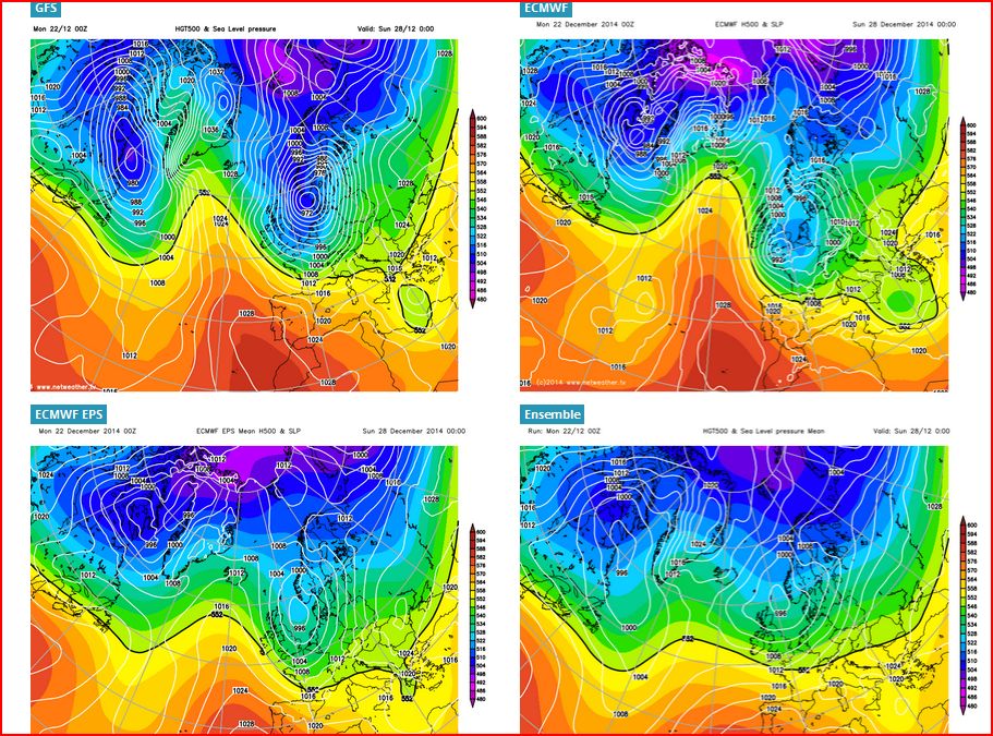
With the 12z GFS op and UKMO op tracks, there’s potential for northerly gales or severe gales around UK coasts Sat/Sun, with the potential for a storm surge towards the Netherlands and affecting the UK North Seas coasts. Not to mention the cold air being pulled south, which could bring the risk of snow to northern and eastern areas next weekend, though this risk dependent on track of the low. But potential we are keeping a close eye on.
Beyond this weekend in the run up to New Year, there has been a lot of chopping and changing from model guidance and divergence between models over recent days, well, more than is usual. So confidence is quite low, even as early as next weekend, given uncertainty of the deep low track near/over the UK. 00/12z ECMWF deterministic and EPS mean showing amplification of the flow upstream over the N Atlantic this weekend, so once it’s weekend low clears SE into NW France, high pressure builds in from the west on Sunday. UKMO also clears the low SE into the near continent but further east then shows a cold NEly flow on Sunday as the low clears SE at t+144. GFS has a weaker more transient ridge following the low clear SE into Denmark. Early next week, with 12z GFS and ECM start the new week with high pressure towards southern UK, but flatten out the ridge by mid-week as Atlantic cyclonic conditions try to return, but high pressure returns to the south later in the week
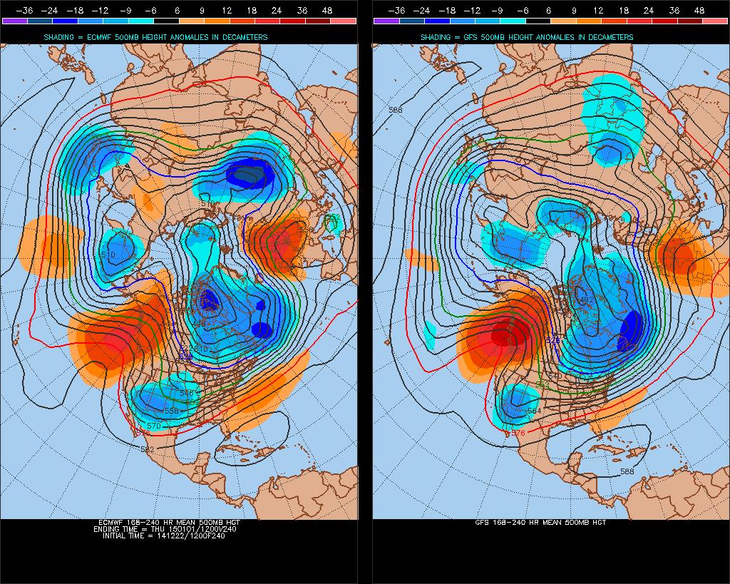
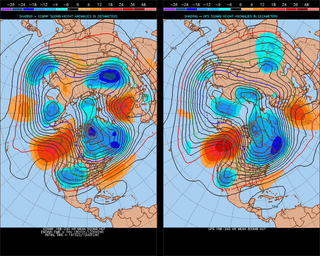
However – the GFS and ECM operational guidance has been chopping and changing in the medium range, and the pattern through next week hinges on whether the potential strengthening of the arctic vortex over Greenland/Baffin/northern Canada next week actually lowers heights again towards the NW the UK, or whether the vortex can dig deep enough upstream over NW Atlantic/NE Canada to maintain the ridging across northern Europe – perhaps even leading to height rises over Scandinavia, as the 00z EPS H500/anomaly and also the 12z ECM 8-10 day H500 chart below suggests. So we could head towards a more settled outlook next week next – than the ECM and GFS operational runs indicate, with perhaps a dry New Year’s Eve with a frost overnight leading into a dry and bright New Years Day.