


Latest synoptic outlook, looking at the likely weather patterns affecting the UK and Europe over the coming 14 days. A blocked pattern across much of Europe, with high pressure dominating across eastern Europe and low pressure close to western Europe over the North Atlantic.

Looking at the upper pattern over the northern Hemisphere for the next 10 days, 500mb flow looks to remain highly amplified across NE Pacific, N America, N Atlantic and Europe over the next 2-3 days, with a ridge across US/Canada west and a deep trough across eastern two thirds of US/Canada, bringing unseasonably cold air here. Downstream, a trough extends increasingly south across the N Atlantic from Greenland towards Canary Islands, with associated cut-off upper low over France today drifting east into central Europe Wednesday. An upper ridge sits over Scandinavia. An easterly flow covers the UK, but not a particularly cold flow
Later this week and over the weekend, we start to see the upper flow begin flatten out upstream over N America, as Pacific trough moves in over Alaska and close to Canadian Pacific coast, collapsing the ridge that has dominated over NW Canada/ E Alaska, with a relaxation north of the cold currently over central and eastern USA. Downstream, upper flow remains highly convoluted over NE Atlantic and Europe, with a trough digging deep towards Canary Islands and moving slowly east in across Iberia, Bay of Biscay, Ireland and far west of the UK by day 5 (Sat 22nd). Temperatures warm up from the south Friday into Saturday, as winds turn southerly for a time. The deep and highly amplified trough is running up against a blocking ridge of high pressure extending north across much of central Europe and Scandinavia. By day 6 (Sunday 23rd) the trough is indicated by major NWP centres to disrupt into a small cut-off low over Morocco and southern Spain vicinity, which will probably allow a ridge of high pressure to build from the SW across the UK.
Early next week on days 7-8 (Mon 24th & Tues 25th), some uncertainty starts to develop with regards to how the N Atlantic upper trough close to NW behaves as it continues to slowly advance east up against the block to the east and northeast. A surface ridge of high pressure looks to be present Monday across the UK, however, ECM and GFS start to weaken heights and pressure from the northwest into Tuesday, this weakness more advanced across Scandinavia too on 18z GFS by Tuesday compared by to the previous run which still had high pressure in charge here.
Days 9 to 10 (Weds 25th to Thurs 26th) – 12z ECM and 18z GFS ops and 12z EPS + GEFS mean broadly agree on slow advance of troughing/lower heights spreading in across NW Europe, with a low pressure system moving in from the NW to the SW of the UK, high pressure by then centred somewhere over western Russia.
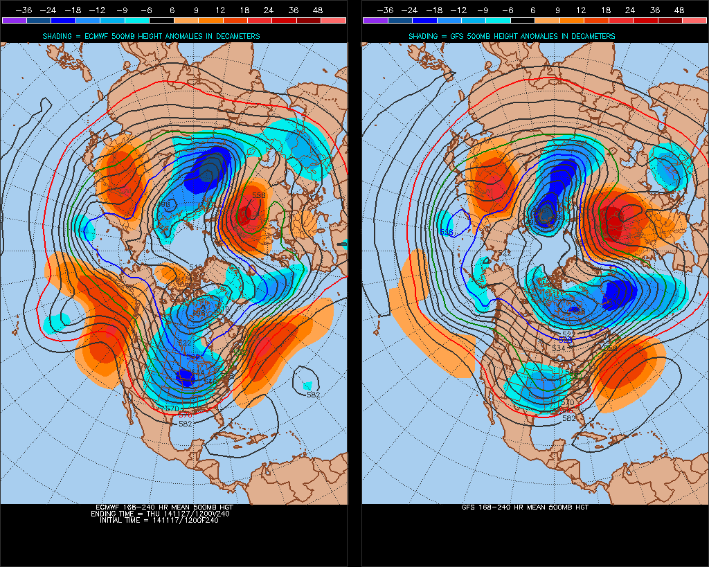
ECM and GFS 8-10 day H500 comparison - courtesy of Dept of Meteorology at Pennsylvania State University
Days 10-14, reverting to model data available after day 10, 18z GFS operational keeps UK right on the edge of Atlantic trough with a cyclonic SWly flow but the trough not really advancing east due to blocking still holding on across eastern Europe and western Russia. Looking at 12z GEFS postage stamps, only a few really going for a return of flatter/zonal Atlantic dominated flow past day 10, most members keep a highly amplified Atlantic trough to the west of the UK and block to just the east pretty much to the end of the run.
So it looks like the stalemate between Atlantic upper trough trying to advance east against stubborn block over eastern Europe and W Russia could continue right until the end of the month.


