


Latest forecast discussion for the UK, covering the next 14 days. Very mild in the south for a time, high confidence for staying generally unsettled, perhaps turning cold enough for northern hill snow next week for a time, but low confidence for now.
General synopsis over next 14 days
Low geopotential heights/upper troughing dominate to the north and west of the UK for the rest of this week, with a strong SWly polar front jet stream running way north in track across northern Scotland. A surface ridge builds across the UK from Wednesday ahead of next trough amplifying W of the UK by end of the week, drawing in a increasingly warm Sly flow. Flow then turns more SWly with cooler conditions following cold front moving E/SE over the weekend. Upper trough moves across UK from the west early next week, amplifying south deep into western Europe towards the Mediterranean. Upstream, a ridge of high pressure tries to build north across the N Atlantic, ahead of next trough coming out of NE Canada. There is some model operational run uncertainty this morning with regards to this ridge. 00z GFS, with good support form GEFS members, shows a transient ridge working downstream across the UK by mid-week once early week trough clears east, with a strong/cold N or NWly flow ahead of the ridge on Tuesday into Wednesday. While 00z ECM quickly flattens out the ridge upstream over the Atlantic, with troughing/cyclonic westerly flow maintained across the UK. Both models show a cyclonic Wly or SWly flow across the UK by the end of the week, with depressions crossing the UK. Then for the 10-14 day period, 00z GFS and GEFS appear to point towards upper trough and surface low pressure close to the NW and high pressure towards the SE, with an unsettled mild W or SWly flow most likely.
Short Term (5 day outlook)
Slow-moving cold front which brought over 200mm of rain to parts of NW Scotland over the last few days finally moves south today into N England and Wales, as a shortwave upper trough pushes SE. Colder polar air follows front from the NW across northern Britain. This front and its rain reaching southern Britain on Wednesday where it will stall before drifting north again as a warm front as flow turns more Sly ahead of next upper trough arriving to west of the UK, as a strong shortwave in the jet coming out of NE Canada digs SE across the Atlantic. This warm southerly flow across the UK deep from SW Europe/Morocco on Friday, with 850mb temperatures of 10C+. A warm front will move north towards Scotland Thursday, taking cloud and light rain/drizzle north with drier and brighter conditions following across central and southern areas Thursday into Friday. Warm Sly flow will lift afternoon temperatures into the mid to high teens on Thursday and Friday, perhaps somewhere in the SE reaching 20C.
Longer Term (6-14 day outlook)
By the weekend, a cold front with rain moving in from the west will introduce slightly cooler SWly returning polar maritime flow across all areas, as upper trough and surface low pressure system move in close to the NW of the UK. Cold front and its rain clears SE England Saturday, followed by brighter, cooler conditions with showers around southern and western coasts Saturday and Sunday.
Increasingly amplified upper trough then moves across the UK/western Europe early next week, bringing further showers or longer spells of rain. Then, model operational runs this morning diverge on Tuesday. GFS develops a cold N or NWly flow as ridge builds to the west behind trough clearing east, with risk of first significant snowfall for higher ground in the north. ECMWF and GEM have no N/NWly incursion, rather low pressure close to/over UK merges with low pressure moving east across the Atlantic with a mobile cyclonic westerly type. Some support for the northerly from GEFS members, so this solution can’t be ruled out, but all depends on phasing of the next trough moving out of NE Canada and whether a ridge can build ahead of it to bring the Nly. Will update on the northerly potential over the next few days.

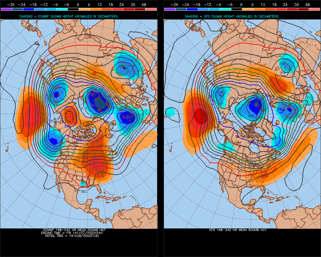
Then fairly good agreement by day 10 (t+240) from ECM, GFS and GEM, that upper trough will be present aloft with pressure low towards the north of the UK bringing a mobile cyclonic W or SWly flow across the UK, though this is about as much detail as can be confident of for now. Days 10-14, ensembles and teleconnections, to an extent, favour a continuation of cyclonic westerly or southwesterly flow with vortex likely close to the NW centred near Iceland or Sern Greenland, with spells of rain or showers continuing for all areas, windy at times – particularly in the north and west with risk of gales, temperatures about normal for northern areas, perhaps slightly above in the south.


