Lastest forecast discussion for the UK, covering the next 14 days. Unsettled conditions continuing until at least early next week. 50% chance of high pressure building across the south from mid-week next week.

General synopsis over next 14 days
The long stretch of unsettled westerlies now looks to continue into early next week and less confidence that pressure will build from the SW as per previous forecasts, though some 50% of GEFS members and ECMWF esemble mean going for some build of pressure from the S or SW from mid-week next week. Once a deep depression (ex-Hurricane Gonzalo) passes NE to north of Scotland tomorrow, the UK looks likely to remain under the influence of persistent low pressure complex to the north near Iceland for rest of this week, over the w/e and into early next week, bringing unsettled conditions and generally mild or very mild conditions with little scope for hill snow. From mid-week, potential for pressure to build from the south, but equally a balance in favour for unsettled westerlies to prevail towards end of the month too.
Short Term (5 day outlook)
Strong westerly jet streak arrives across UK Monday night, with it a deep depression (remnants of ex-Hurricane Gonzalo) which will track NE to the north of Scotland Tuesday, the low around 975mb close to Northern Isles at noon Tuesday. Active cold front bringing heavy rain sweeps east early Tuesday morning, clearing east coast by mid-morning. Strong/gale force SWly ahead of cold front veering strong/gale/severe gale force NWly colder flow following front. Transient ridge of high pressure quickly builds in from the west by early Wednesday before pressure falls from the NW during Wednesday, with arrival of new Atlantic frontal system across northern Britain, bringing cloud and rain. Then persistent low pressure system remains close to Iceland for rest of the week, driving an unsettled/cyclonic SWly flow across the UK. A cold front, bringing rain, erratically moves SE across the UK on Thursday and Friday, probably clearing SE England Friday afternoon.
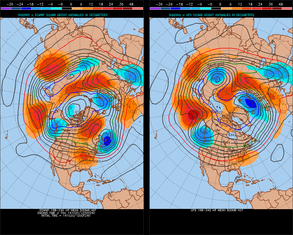
Longer term (6-14 day outlook)
Perhaps drier for southern Britain over the weekend, but closer to low pressure system near Iceland - northern Britain will experience Atlantic fronts and strong SWly flow which will bring cloud and rain at times. Rain persistent and heavy across western Scotland – especially windward slopes.
Pressure falling from the NW across all parts early next week, with Atlantic frontal systems making inroads further south and east – bringing threat of some rain to all areas. Not a great deal of confidence mid-week onwards, but 50% chance that pressure will start to build from the south just to the W or SW of UK mid/late week as trough amplifies upstream over Atlantic, which may bring in drier weather to southern parts and/or bring a cooler northwesterly flow by end of the week. The north/south split (drier south/unsettled north) could persist into following weekend (Sat 1st Nov and Sun 2nd Nov), increasing risk of frost/fog in south under high pressure while north sees risk of cloud, rain and windy conditions at times.
ECMWF/GFS 8-10 day mean 500mb heights (orange = ridging, blue = troughing):