
Latest synoptic discussion for the UK, covering the next 14 days. Remaining unsettled, a northwest-southeast split likely later.

General synopsis for next 14 days
Models are in fairly good agreement over the 500mb pattern for the next 6-10 days. Mean upper trough axis will lie NE to SW across northern and western UK for the rest of this week – tending to become more amplified by the weekend, with a deeply cyclonic southwesterly flow across much of the UK ahead of main surface low pressure low pressure system moving NE across Ireland and Scotland over next few days. Upper troughing will persist over the UK and much of the North Atlantic area over the weekend, with the polar front jet stream forced way south across the Atlantic toward Morocco before returning NNE across Spain, France and the Low Countries, the UK under a cyclonic southwesterly or westerly flow.
GFS, ECMWF and UKMO have Atlantic upper troughing amplifying deep across western Europe early next week with cyclonic southwesterly flow persisting, while upper ridge persists across SE and E Europe.
There are then subtle differences after mid-week (days 8-14) from the morning medium range output, GFS has a shortwave moving out across the N Atlantic, which deepens/amplifies a trough mid-Atlantic more than ECM with a corresponding build in heights/pressure across Europe – so a more amplified flow, while ECM keeps the flow flatter with less ridging across Europe . Though both models maintain a cyclonic southwesterly flow across the British Isles early in the week, with pressure lower towards the NW, higher towards the SE, after mid-week next week differences arise between 00z ECM and 00z/06z GFS – with GFS building a ridge across the UK by end of next week. An area of high pressure features on GFS across the UK the weekend of 18th/19th
Short term (until the end of this week)
A deep area of low pressure sits west of Ireland today, with deeply cyclonic southwesterly flow across the UK which is bringing an unstable and showery regime across many areas, though showers mostly confined to coastal areas. A shallow low and associated fronts moving north across Scotland is bringing more general rain here. Low to the west moves NE across Ireland on Wednesday, slowly filling, with another day of sunshine and showers (locally heavy and thundery) for many areas, though less showers over northern Scotland once early rain clears. Low pressure slowly fills over northern Britain on Thursday and Friday, so further showers are likely – particularly near coastal areas, where they maybe thundery.
Longer term (this weekend through to Monday 20th October)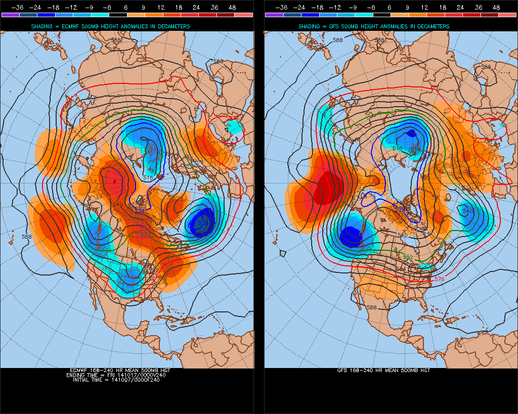
Models suggest shallow low pressure to remain in control across the UK early next week, though exact centre of low pressure and circulation remains uncertain. So the weather looks to remain unsettled, with further showers or longer spells of rain, though winds will be generally light and variable away from the far west where they may strengthen later on Tuesday. From mid-week, there are hints that a deep depression will develop mid-Atlantic, as a shortwave trough sharpens as moves east out of NE Canada. As this deep low approaches the far west, southwesterly wind strengthening across all areas, though strongest towards the NW, with wet and windy weather possible across Ireland and NW Britian. However, it maybe drier towards SE Britain, as pressure slowly rises here. There are some uncertainties towards the end of next week on how far deeper low pressure to the west moves east and whether pressure will build from the south as per GFS operationals. On balance, taking in a blend of ECMWF and GFS ensembles, it looks like 10-14 day period will be more unsettled towards the north and west, drier and more settled across the south and east.


