


The latest synoptic discussion of the UK weather for the next 14 days. More unsettled, cooler and windier conditons to prevail as we head through early October.
General synopsis for next 14 days
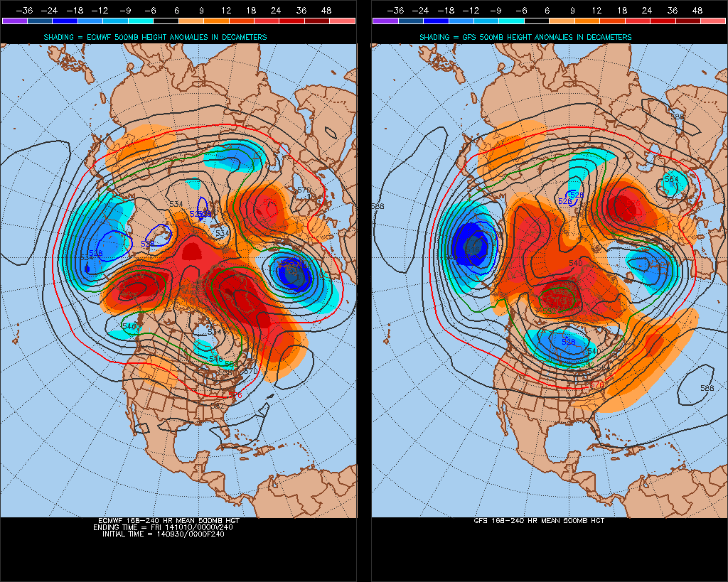
Models are in generally good agreement over the 500mb pattern for the next 14 days. Mean upper trough will persist to the NW of the UK for the rest of this week, the trough axis beginning to transfer southeast towards the UK by the end of the week, with a corresponding fall in heights and surface pressure over UK and an increase in wind and rainfall from the northwest. Upper trough axis will then be just west of the UK this weekend, before shifting over the UK next week, with strong signal for an upper low to become slow-moving close to northern Britain, with deeply cyclonic/unsettled conditions prevailing. So a more seasonal first half to October is likely.
Short term (until the end of this week)
Upper level troughing and surface low pressure systems to the NW of the UK will increasingly influence the weather over the UK for the rest of this week. Ahead of a deepening low pressure system arriving across western Iceland in next 24 hours, a cold front arrives across western areas of the UK this afternoon, bringing thicker cloud and outbreaks of rain. This front will move east across the UK overnight, weakening as it encounters high pressure over the near continent, the front clearing southeast England and East Anglia Wednesday morning. Another cold front follows closely from the west across northern and western areas Wednesday morning, bringing more cloud and patchy rain to England and Wales on Wednesday as it slips south and east, followed by brighter, clearer and cooler conditions across Scotland, N. Ireland and northern England by the evening.
Despite generally high pressure across southern areas on Thursday, weak remnant front that moved in from the west on Wednesday looks to linger here, perhaps bringing a cloudy start with patchy drizzle. Clearer and fresher condtions across the north, slowly spreading south to all areas.
Isobars tighten from the northwest later on Thursday and into Friday across the northern half of the UK, as a deep area of low pressure moves across Iceland and an active cold front pushes southeast across the UK. So a band of heavy rain and strong winds look to arrive across the northwest in the early hours of Friday, before spreading southeast across Scotland, EIRE, N Ireland, far north of England and northwest Wales during Friday. 25-30mm look likely from the frontal system in these areas, perhaps 50-60mm locally over higher ground - particularly if a wave develops along the cold front and moves NE, as some models indicate. Winds gusts of up to 55-65mph are indicated around northern and western coast and over hills.
Longer term (this weekend through to Monday 13th October)
Friday's active frontal system across the north looks to clear east from eastern England early Saturday afternoon, with winds generally easing away from the far northwest. Drier and clearer conditions then look to follow across central, southern and eastern parts for the rest of the weekend, but for northern and western areas, blustery showers look likely, perhaps merging into longer spells of rain on Sunday and winds reaching gale force in the northwest, as another Atlantic frontal system arrives.
It looks to remain unsettled into next week, as mean upper trough axis settles over or just west of the UK and slow-moving 'parent' low becomes established close to northern Scotland, with secondary features circulation around it further south. This means spells of heavy rain or showers (perhaps thundery) spreading east or northeast across the UK, with drier and brighter interludes as well, especially towards the southeast. Highest rainfall totals likely towards the north and west. Windiest in the north and west too, with a risk of gales at times, perhaps severe gales around coasts and over hills here. Generally breezy or windier than of late and cooler too. These conditions probably lasting right through the second weekend of October.


