The annual ESOTC is a key evidence report about European climate and past weather. High temperatures, heatwaves, wildfires, torrential rain and flooding, data and insight from 2023,
The 2023 European State of the Climate (ESOTC) report was issued this April with the headline “Europe experiences widespread flooding and severe heatwaves in 2023”
ESOTC looks at climate conditions and anomalies, key weather events and their impacts as well as climate action and policies. We need to understand climate trends and consequences to plan for more impacts and to adapt.
“In 2023, Europe witnessed the largest wildfire ever recorded, one of the wettest years, severe marine heatwaves and widespread devastating flooding. Temperatures continue to increase, making our data ever more vital in preparing for the impacts of climate change.” Carlo Buontempo Director, C3S
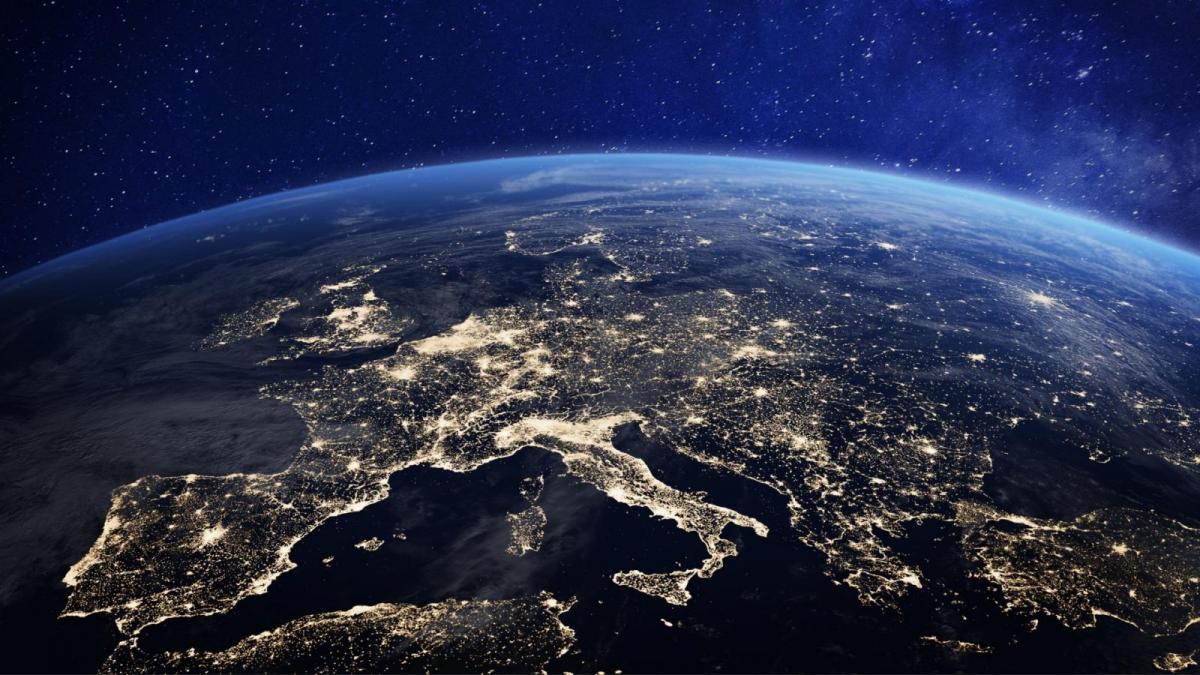
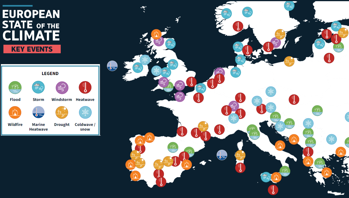
It covered record-breaking temperatures, heatwaves, flooding, rapidly shrinking glaciers, marine heatwaves and the largest wildfire ever recorded in the European Union. It is published by Copernicus Climate Change Service (C3S) and the World Meteorological Organisation (WMO). Europe was the fastest-warming continent, with temperatures rising at around twice the global average rate. The three warmest years on record for Europe have all occurred since 2020.
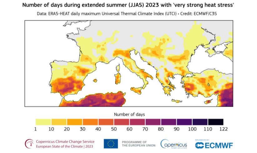
2023 was the joint warmest or second warmest year on record depending on the dataset. • Temperatures in Europe were above average for 11 months of the year, including the warmest September on record. • 2023 was the sixth warmest on record for the Arctic as a whole. 2023 saw a record number of days with ‘extreme heat stress’. More people are dying from heat-related deaths and more people suffering adverse health impacts from extreme weather or climate events.
“Evidence from the last decade shows generally good awareness but a low-risk perception of heat by the public, vulnerable groups and some health care providers.”
In the UK we now have extreme heat warnings from the Met Office as part of the suite of warnings in the National Severe Weather Warning Service but it is hard work getting across the health concerns for sustained ‘heat stress’ when sunny and hot has been portrayed as “good weather” for so long. That, there isn’t anything to worry about with summer heat so do as you please. Also, heat and sun almost become a mythical quest, what will our summer be like this year? Never mind the strain that heat can quietly bring.
There is a heat-health forecast for England now, giving early warning to providers. Health risks and adaptation differ between countries across Europe north to south, and around the world. A heatwave in the UK has different thresholds than a heatwave in Italy.
“Heat stress is a measure of how the human body responds to the impact of high temperatures combined with other factors such as humidity and wind speed, amongst others [such as timespan & tropical nights]. Prolonged exposure to heat stress can exacerbate existing health conditions and increase the risk of heat-related illnesses such as heat exhaustion and heatstroke, particularly among vulnerable populations. “
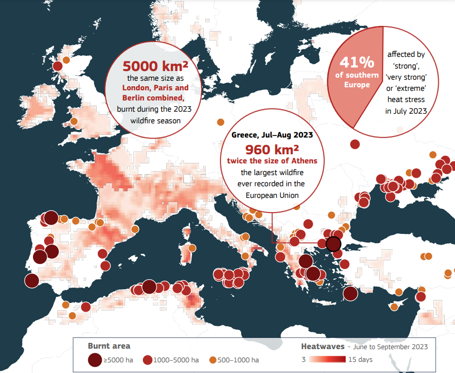
36,000 people were affected by wildfires and 44 lost their lives. An area around twice the size of Luxembourg was burnt in the EU and produced 20 megatonnes (Mt) of CO2 emissions – as estimated by EFFIS – equivalent to nearly a third of all emissions from international aviation in the EU in one year. The season had started early with large fires in Spain in spring. However, the wildfire activity peaked in the summer months, when fire danger conditions became critical in the Mediterranean region and mainland Greece. Conditions of dry soil, low humidity and high winds facilitate the ignition of wildfires and their propagation. Very high/extreme wildfire danger conditions are more likely with climate change.
Researching and gathering data can allow governments and organisations to act, looking at vegetation management, fire fighting practices and improving early warning systems.
There have been high sea surface temperatures. “ In June, the Atlantic Ocean west of Ireland and around the United Kingdom was impacted by a marine heatwave …with sea surface temperatures as much as 5°C above average.” This was far higher than anything seen in historical records with another marine heatwave in the Med by mid-summer.
Met Eireann “A category 4 ‘extreme’ heatwave in parts of the north Atlantic off the coast of Ireland occurred in June 2023, with some hotspots hitting category 5, ‘beyond extreme’. Climatologist Paul Moore states: “We are seeing sea surface temperatures around what we would get in August rather than June…The current marine heatwave around Ireland is likely caused by a combination of natural variability and background warming due to climate change.” The natural variability is related to nearby high pressure with light winds but high solar radiation.
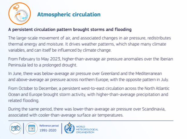
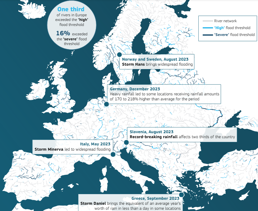
During 2023, Europe as a whole saw around 7% more precipitation than average. In December, river flows were the highest on record. One third of the European river network saw river flows exceeding the ‘high’ flood threshold, and 16% exceeding the ‘severe’ flood threshold. This led to tens of thousands of people being displaced and also loss of life. Extreme rainfall led to devastating events with widespread flooding in several European countries, as southern Europe experienced widespread drought.
Flooding affected 1.6 million people in 2023 in Europe and over half a million people by storms. This included the hundreds affected by Storm Babet in the UK. This was the most impactful storm for the UK in 2023 focusing on eastern Scotland with two red rain warnings as England and Wales saw the third-wettest independent 3-day period in a series from 1891 and the Midlands provisionally recorded its wettest 3-day period on record.
“With the changing climate, we face more frequent and severe floods, rising sea levels and faster rates of coastal erosion. We must be prepared to deal with longer, heavier bouts of rain regularly. Events like Storms Babet and Ciarán are becoming less ‘exceptional’ and more ‘routine’.” Welsh Government
The report also looks at renewable energy resources with more positive news. electricity generation increased, although that was sometimes linked to increased storm activity. River hydro power generation was helped by the fast-running rivers and Solar photovoltaic power generation increased. It also covered snow and glaciers in Europe with fewer days of snow than average recorded, particularly for central Europe and the Alps.
The frequency and severity of extreme weather events are on the rise. None of this is a surprise. It is happening now. The ESOTC annual report highlights how extreme temperatures and severe weather events impact societies, the land, the oceans and human health. This is a document of evidence for Europe.
Celeste Saulo, Secretary-General, WMO: “The climate crisis is the biggest challenge of our generation. The cost of climate action may seem high, but the cost of inaction is much higher. As this report shows, we need to leverage science to provide solutions for the good of society.”