The Jetstream and The Weather in the UK
In order to understand the jet stream you need to have some idea of what is
occurring in the atmosphere nearest the ground; known as the troposphere. It
is also helpful to understand the formation of Hadley, Ferrel and Polar cells and
how The Coriolis Effect influences these tropospheric cells. The jet stream flows
in both hemispheres around the earth, but for ease this article will consider the
Northern Hemisphere only.
The jet stream is a strong flowing ribbon of air that flows around our planet high
up in the atmosphere, at around the level of the tropopause. Situated between the
troposphere and the stratosphere, the Jet Stream is approximately 11 kilometres
above the surface of the Earth at the poles and around 17 kilometres above the
surface of the Earth at the equator. The jet stream flows at around 160kmph
(100mph). We often hear that the jet stream is responsible for influencing the
weather in the UK, so it is natural to wonder what causes the jet stream and why
it has such an influence on the weather we experience on the ground.
Jet streams form and are strongest where variable air temperature gradients are
steepest. This is normally seen in two zones:
-
The boundary between the polar and mid latitude air . The Polar Front
Jet or Polar jet
- The boundary between the mid latitude air and tropical air . The
Subtropical Jet.
Both these jets are separate entities but they can join up from time to time across
an area of the earth. The polar jet is the strongest as the temperature gradient
across Polar and mid latitude regions is greatest. This is increased again in the
Northern Hemisphere during winter. Both the subtropical jet and the polar jet
travel from west to east and both would travel uniformly and evenly around the
earth if it wasn.t for other influencing factors.
See
Fig 1. below for an example of a typical jet stream chart across the earth.
Typical JetStream
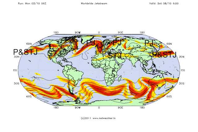
Click to enlarge
The STJ is the area where the subtropical jet is flowing, the PJ
is an area where the polar jet flows and the P&STJ shows where the jet streams
have combined.
Influencing factors on the Jet Stream flow
The factors that influence the flow of the jet stream are the landmasses and the
Coriolis effect. Landmasses interrupt the flow of the jet stream through friction
and temperature differences, whilst the spinning nature of the earth accentuates
these changes. So the jet stream meanders across the earth, like a river meanders
before it reaches the sea. The meandering sections of the jet stream continue to
change as they interact with landmasses once again, creating an ever-changing
state of flux and subsequent temperature differences.
In winter the temperature of the stratosphere can also have an effect on the
strength and position of the jet stream. The cooler the polar stratosphere, the
stronger the polar/ tropical differential becomes; encouraging the jet stream to
gain in strength. The warmth of the landmasses and oceans (such as the El Nino
Southern Oscillation) can also have a bearing on the strength and amplitude of
the jet stream.
Jet Stream Variables
The strongest areas of the jet stream are known as jet streaks. These are areas
where the jet stream has increased in speed by as much as 100kmph. A typical
jet streak is 160km wide, 2-3 km thick and lasting several hundred km in length.
The strongest jet streams are seen where the upper air temperature differentials
are greatest, the weakest jet streams appear when the opposite is true. Strong jet streams tend to have very little meandering associated with them whereas weaker jet streams have a considerable amount of meandering associated with them.
A Summary of the Jet Stream
- Jet streams are strong upper air currents circumnavigating the globe.
- There are two main jets: the polar jet and the subtropical jet.
- Jet streams can fluctuate in strength between 100-200mph.
- The jet stream meanders in waves.
How does the jet stream affect the weather in the UK?
To try explain how the jet stream affects the weather in the UK, it is worth going
back to the jet stream chart seen in
Fig 1, now zoom in to the jet stream analysis
over the Atlantic as seen in
Fig 2.
Jet Analysis
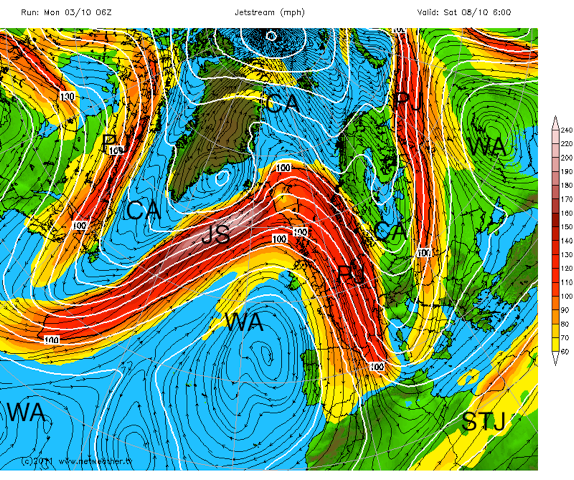
Click to enlarge
The jet stream is shown in pink at its strongest point fading to yellow at its
weakest.
CA=cold polar air,
WA=warmer air,
PJ=polar jet,
STJ=subtropical jet,
JS=jet streak.
From
Fig 2. you can see that the polar front jet meanders across the country in a
wave like pattern. These waves introduce pockets of colder air southwards and
warmer northwards. The temperature change is demonstrated by looking at the
air temperature at a high enough altitude in the atmosphere, where ground and
sea temperatures do not affect it .around 1500 metres in altitude where the air
pressure is around 850 hPa.
Fig 3. shows how these temperatures match the fluctuations in the jet stream.
Jet + 850hpa Temps
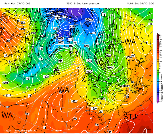
Click to enlarge
From looking at
Fig 3 and the 850-hPA temperatures you can see the clear
boundaries between the cold and warm air masses, which is being divided by
the polar jet. You can also see the demarcation between warm and hot air that
the sub tropical jet is demarcating. This demonstrates the pattern of the jet
stream, showing how it is linked to and by the difference in warmer and cooler
air masses.
Furthermore, looking back at
FIG 2, the wave pattern associated with the polar
jet has distinct peaks (ridges) and troughs. It is no surprise to find that when we
overlay the jet stream with a chart showing sea level pressure, that the ridges
occur where sea level pressure is highest and the troughs occur where sea level
pressure is lowest (as
FIG 4 demonstrates). This is because air rises where troughs are situated and sinks where ridges are occur. Rising and sinking parcels
of air will therefore determine the type of weather that a region experiences.
Ridges and Troughs
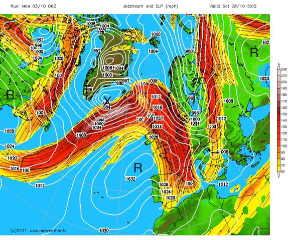
Click to enlarge
ridge,
T=trough,
X=deep sea level depression or low.
Look at the area
X on
Fig 4. which is situated towards the west of Iceland. This
is a common cyclonic or baroclinic depression that is caused by the difference
in pressure and temperature over a region. This is feeding strength to the jet
stream, which is then invigorating the depression.
In contrast,
Fig 5 shows the same chart from
FIG 2. However, note the following
points:
- The circled area is where the jet stream is strongest . the jet streak.
- The purple box marks the winds entering the jet streak.
- The winds leaving the jet streak are marked by the black box.
The winds leaving the jet streak are rapidly diverging, creating a lower pressure
at the upper level (tropopause) in the atmosphere. The air below rapidly
replaces the upper outflowing winds. This in turn creates the low pressure at
the surface (marked
X on
fig 4). This surface low pressure creates conditions
where the surrounding surface winds rush inwards. The Coriolis effect creates
the cyclonic rotation that is associated with depressions. The strongest surface
winds in any developing depression are normally seen at the left exit point of the
jet streak, where the jet streak is strongest.
Jetstreak
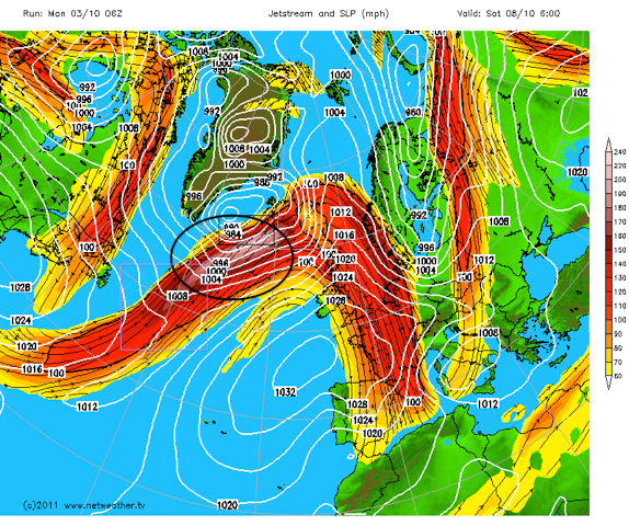
Click to enlarge
The black oval indicates a jet streak, the purple square indicates entry
winds into the jet streak and black box indicates rapidly diverging exit winds.
The positioning and strength of the jet stream determines where ridges and
troughs are associated and this in turn influences the surface weather.
Zonality and Meridional flow.
During periods when the jet stream is flat and strong with little amplification or
meandering, the UK is likely to experience weather that is driven straight in from
the Atlantic. This is characterized by wet and windy weather with temperatures
near to average. This condition is often termed .zonality. as the warm and cold
air masses are clearly defined by a straight fast flowing jet.
During periods when the jet stream is amplified (such as
Fig2) the pattern will
be different. This is often termed meridional with polar air travelling further
south than usual and warmer sub tropical air travelling further north. The exact
positioning of the amplification of the jet stream will determine whether or not
the UK is in cold polar air or warmer air from lower latitudes. If a meridional
pattern becomes stagnant then the UK may experience either of these conditions
for a period of time and the pattern may be known as .blocked..
Summary of the Jet Stream and the weather it creates:
- The position of the jet stream over the UK determines the type of weather
we experience.
- If the polar front jet is situated significantly to the south of the UK we will
experience colder than average weather.
- If the polar front jet is situated to the north of the UK we will experience
warmer than average weather.
- If the polar front jet is situated over the UK we will experience wetter and
windier than average weather.
- If the polar front jet has a large amplification then cold air will travel
further south than average and warm air will travel further north than
average.
- The direction and angle of the jet stream arriving at the UK will determine
what source of air (i.e. cold, dry, warm, wet, from maritime or continental
sources) the UK experiences.
Article written by
Ed O'Toole
View The Jetstream Forecast Here


