Updated 16th April - Covering 22nd April - 14th May 2024
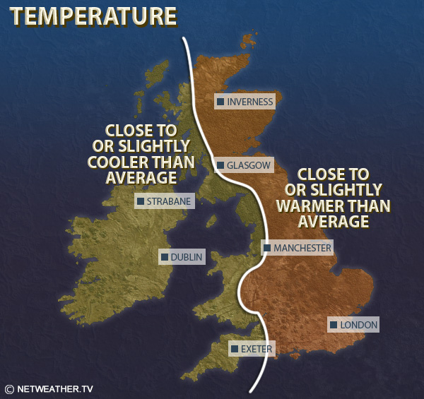
Temperatures will probably not be far from the long-term normal, but despite frequent north-easterly winds, the record high global temperatures and high sea surface temperatures around the UK should prevent it from being substantially colder than average. It will probably be 0.5 to 1.0C warmer than average in most western parts of the UK, and within 0.5C of the average in most eastern areas, with eastern England most likely to be slightly cooler than average.
Rainfall looks set to be below average in most regions, though in parts of southern and eastern England, particularly East Anglia, it may come out near normal.
Sunshine totals are forecast to be well above normal in western Scotland, Northern Ireland and north-west England, and moderately above normal in most other western regions. They are likely to be below normal in parts of eastern England, especially East Anglia and near North Sea coasts.
This week looks set to be predominantly dry and settled, with high pressure often centred over the west of Britain, or just out to the west of the British Isles, perhaps becoming centred more to the north-west late in the week. As a result, winds will often be northerly early in the week, and turning north-easterly towards the end of the week. They will not bring in especially cold air masses because they will not be pulling air in from very far north, but they are likely to bring a fair amount of cloud in off the North Sea. Thus, the weather will often be cool and cloudy in eastern England, especially in East Anglia and near North Sea coasts, and some bands of light rain are likely to affect mainly eastern parts of Britain at times as well, though not generally amounting to much. In western parts of Britain, particularly in Northern Ireland, north-west England and most of Scotland, the weather is likely to be predominantly sunny and dry, with temperatures often above average by day, but with cool nights due to the clear skies and light winds.
Mean temperatures are forecast to be about 1C above the 1991-2020 long-term average in most western parts of the UK, but up to 1C below average in eastern England, particularly in East Anglia.
It is forecast to be drier than average everywhere, probably only moderately so in eastern England but much drier than average in western parts of the country. Sunshine totals are expected to be below normal in parts of eastern England, particularly near North Sea coasts and in Norfolk, but above average in most western areas, especially north-west England, Northern Ireland and western Scotland.
It looks probable that north-easterly winds will again feature frequently during this week, which is not particularly unusual at this time of year, but it means that there is potential for temperatures to drop below normal at times, particularly in eastern parts of England. It is likely to again be drier than average for most, if not all, especially in north-western Britain, where pressure will often be highest. Rain is most likely to affect eastern areas at times, particularly East Anglia and south-east England, also with potential for some outbreaks of rain or showers and potential for thunder to affect the south of England generally at times, particularly near the English Channel coast. It is expected that there will be plenty of sunshine in north-western Britain, but eastern England may again be rather cloudy at times.
Mean temperatures are likely to be close to normal for most, but potentially 1 to 2C below normal in parts of eastern England. Rainfall totals may reach close to normal amounts in parts of southern and eastern England, but again for most of the country it is expected to be dry. Sunshine is forecast to be well above normal in western Scotland and in Northern Ireland, but probably below normal in south-east England and East Anglia.
The weather is likely to turn rather more unsettled from the south-west towards mid-May, with high pressure moving further away to the north-west and allowing low pressure to develop to the west of Britain, potentially bringing a not dissimilar setup to what we've often been used to recently. There is some uncertainty over whether this transition will happen during the first half of May or not until after midmonth, and the weather early in the period is most likely to remain dry and settled, though with potential for it to remain rather cloudy at times in the east.
Temperatures are most likely to be near to slightly above normal overall, with a tendency towards north-easterly winds again early in the period perhaps becoming more southerly towards the end of the period, which would allow warmer temperatures at times. It will probably again be drier than normal for most, particularly in north-western Britain, but with potential for the southern half of England to have near or above average rainfall if the more unsettled regime kicks in before mid-May. Sunshine is likely to be above normal in northern and western Scotland but below normal in eastern and southern England.
Monthly weather forecast
The month ahead forecast is written by Ian Simpson and is updated every Monday.